more stats
2,073 ft
Distance
-362 ft
Descent
00:06:27
Avg time
-363 ft
Altitude change
2,172 ft
Altitude min
2,535 ft
Altitude max
2,535 ft
Altitude start
2,172 ft
Altitude end
-17.5%
Grade
-39.4%
Grade max
1.9%
Grade min
56 ft
Distance climb
1,804 ft
Distance down
213 ft
Distance flat
00:06:27
Avg time

Otesanek Details

  • Activities
    • Mountain Bike
    • E-Bike
  • Riding Area
  • AKA
    Nostromo
  • Difficulty Rating
  • Voted Difficulty
    Black (4 votes)
  • Local Popularity
    50 in Mountain Biking [+]
    • 20 in E-Biking
  • Global Ranking
    #94086 in Mountain Biking [+]
    • #101258 in E-Biking
  • Trail Type
    Singletrack
  • Bike Type
    DH, AM
  • Direction
    Downhill Only
    Popular Direction Shown
  • Climb Difficulty
    Blue
  • Physical Rating
    Moderate
  • eBike Allowed
    Yes up to Class 1
  • TTFs on Trail
    Berm, Drop, Jump, Gap Jump, Rock Garden, Other

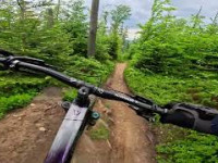
Jest to krótka, ale soczysta odnoga dolnej części Otika, zaczyna się zaraz po przejeździe drogi w okolicach Polany Suche a kończy w Solisku. Trasa posiada parę hopek z dziurami, dropów oraz dwie strome ścianki na samym końcu.

Trail Supporters

Bike Park

Recent Activity on Trail

Past Week
  • 0 rides
  •  
6 Months
  • 3 rides
  • 24 miles avg distance
All
  • 55 rides
  • Last: Jun 7, 2026
c1c2c3c4
January
February
March
April
May
June
July
August
September
October
November
December
update trails status or condition

Otesanek Trail Reports

statusdatedescription
Jun 6, 2026 @ 12:52pm (Europe/Warsaw)
Jun 6, 2026
Dużo luźnych kamieni ostrych pod stopem przy wjeździe na trasę narciarska ,moja opinia tego nie wytrzymała
Sep 21, 2025 @ 1:13pm (Europe/Warsaw)
Sep 21, 2025
Aug 23, 2025 @ 9:54am
Aug 23, 2025
Jul 6, 2025 @ 12:26pm
Jul 6, 2025
Aug 11, 2024 @ 2:48am
Aug 11, 2024
more »
Status:
on Jun 6, 2026
Ideal
Avg: 4.26 (5 votes)
Your vote: 0

view (723)
close
3D
Trail Conditions
  • Unknown
  • Snow Groomed
  • Snow Packed
  • Snow Covered
  • Snow Cover Partial
  • Freeze/thaw Cycle
  • Icy
  • Prevalent Mud
  • Wet
  • Variable
  • Ideal
  • Dry
  • Very Dry
Trail Flow (Ridden Direction)
Trailforks scans users ridelogs to determine the most popular direction each trail is ridden. A good flowing trail network will have most trails flowing in a single direction according to their intension.
The colour categories are based on what percentage of riders are riding a trail in its intended direction.
  • > 96%
  • > 90%
  • > 80%
  • > 70%
  • > 50%
  • < 50%
  • bi-directional trail
  • no data
Trail Last Ridden
Trailforks scans ridelogs to determine the last time a trail was ridden.
  • < 2 days
  • < 1 week
  • < 2 weeks
  • < 1 month
  • < 6 months
  • > 6 months
Trail Ridden Direction
The intended direction a trail should be ridden.
  • Downhill Only
  • Downhill Primary
  • Both Directions
  • Uphill Primary
  • Uphill Only
  • One Direction
Contribute Details
Colors indicate trail is missing specified detail.
  • Description
  • Photos
  • Description & Photos
  • Videos
Trail Popularity ?
Trailforks scans ridelogs to determine which trails are ridden the most in the last 9 months. Trails are compared with nearby trails in the same city region with a possible 25 colour shades. Think of this as a heatmap, more rides = more kinetic energy = warmer colors.
  • most popular
  • popular
  • less popular
  • not popular
ATV/ORV/OHV Filter
Max Vehicle Width
inches
US Cell Coverage
Legend
cell carrier legend

Radar Time
Activity Recordings
Trailforks uses anonymized public activity data. ?
Activity Recordings
Trailforks uses anonymized public activity data. ?
Personal Heatmap
Activity Types
all / none
Options
2
Date range month
Winter Trails
Warning A routing network for winter maps does not exist. Selecting trails using the winter trails layer has been disabled.
Missing Trails
Most Popular
Least Popular
Trails are colored based on popularity. The more popular a trail is, the more red. Less popular trails trend towards green.
Jump Magnitude Heatmap
Heatmap of where riders jump on trails. Zoom in to see individual jumps, click circles to view jump details.
BC Backroad Status

Service Road Atlas is a free to use, community-driven service for viewing and creating reports on the numerous back-country service roads around B.C. and Alberta.

map legend
Slope Aspect
Direction the slope faces
Flat N NE E SE S SW W NW
Trails Deemphasized
Trails are shown in grey.
disable
Only show trails with no bike usage.
Enable
Suggested Layers
Based on selected activity type

    Save the current map location and zoom level as your default home location whenever this page is loaded.

    Save
        Directions to otesanek trailhead (49.682220, 18.981860)

        Photos

        1 more »
        347 |
        Jan 31, 2021 @ 2:20am
        Jan 31, 2021
        26 |
        Sep 25, 2025 @ 5:30am
        Sep 25, 2025

        Videos

        2 more »
        SZCZYRK - Otik + Otesanek
        47 | Jun 13, 2025 , Szczyrk
        TrailDIRECTOR - OTESANEK -  SZCZYRK!
        6:39 | 223 | Nov 22, 2022 , Szczyrk

        3 Reviews & Comments


        We hope you've been enjoying Trailforks!

        Create a FREE account to view trail comments and much more.

        Frequently Asked Questions About Otesanek

        Where is Otesanek located?
        Otesanek is located in Enduro Trails Szczyrk, Szczyrk, Poland. It is part of the Enduro Trails Szczyrk trail network. The trailhead is located at coordinates 49.68222, 18.98186.
        How hard is Otesanek?
        Otesanek is rated as Black difficulty. The physical rating is Moderate. The average grade is 17.5%. The climb difficulty is rated Blue.
        What is the elevation gain for Otesanek?
        The trail has 110 m of elevation descent. The elevation ranges from 662 m to 773 m.
        Is Otesanek a point to point trail?
        Yes, Otesanek is a point to point trail. The direction is Downhill Only. The trail type is singletrack.

        Hit the Trail

        Open in App

        Get this trail on your phone instantly.
        open trail in app

        Download Trail

        Save to wishlist, Garmin & download.
        save the trail

        Find Related Routes

        Find routes and users activities that include this trail.
        find routes for this trail

        You must enter a description before submitting.