more stats
1.1 miles
Distance
52 ft
Climb
-546 ft
Descent
00:09:45
Avg time
-494 ft
Altitude change
3,133 ft
Altitude min
3,650 ft
Altitude max
3,627 ft
Altitude start
3,133 ft
Altitude end
-8.7%
Grade
-49.6%
Grade max
15.5%
Grade min
883 ft
Distance climb
4,377 ft
Distance down
390 ft
Distance flat
00:09:45
Avg time

Otter Pop Details

  • Activities
    • Mountain Bike
  • Riding Area
    Spencer Mountain
    Whitefish, Montana
  • Difficulty Rating
  • Voted Difficulty
    Blue (3 votes)
  • Local Popularity
    100 in Mountain Biking
  • Global Ranking
    #21060 in Mountain Biking
  • Trail Type
    Singletrack
  • Bike Type
    DH, AM, XC
  • Direction
    Downhill Only
    Popular Direction Shown
  • Climb Difficulty
    Green
  • Physical Rating
    Easy
  • Trail Visibility
    Always easy to follow
  • Dogs Allowed
    Yes
  • TTFs on Trail
    Berm, Bridge, Drop, Jump, Gap Jump, Ladder Bridge
  • Year Opened
    2014

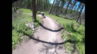
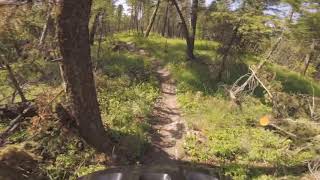
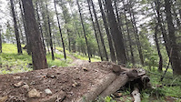
A fast and flowy trail with recently rebuilt large berms and optional features and gaps. This is the best place to start at Spencer, nothing is too technical or mandatory, just fun and fast.

Access Info

Head West of Whitefish on Highway 93, Spencer Lake will be on the left, take the next left on Twin Bridges Road. The trailhead is on your left. Follow the access road up to a flat spot where the road plateaus. The Otter Pop trailhead is on your right.

Local Trail Association
Traditionally Indigenous Territory

Recent Activity on Trail

Past Week
  • 12 rides
  • 15.1 km average
6 Months
  • 65 rides
  • 13.5 km avg distance
All
  • 861 rides
  • Last: Jun 19, 2026
c1c2c3c4
January
February
March
April
May
June
July
August
September
October
November
December
update trails status or condition

Otter Pop Trail Reports

statusdatedescription
Feb 11, 2026 @ 4:18pm (America/Denver)
Feb 11, 2026
Mostly clear of snow. All logs are cut out. There's still 3 root balls that need attention. One root ball right before the step up took the...
Oct 10, 2025 @ 3:03pm (America/Denver)
Oct 10, 2025
reporter
FAMB Trail Crew buffed the tread from the summit to the bottom! Removed brake bumps, smoothed berms, improved drainage, and did a general tidying...
Aug 30, 2025 @ 4:31pm
Aug 30, 2025
A bit dusty and beat up from the season but still riding pretty good. Such a well made trail. Never gets old.
May 9, 2025 @ 1:12pm
May 9, 2025
reporter Trail is riding great!
Oct 2, 2024 @ 6:15pm
Oct 2, 2024
Dusty, dry, and bumped out...solid end of season riding conditions.
more »
Status:
on Feb 11, 2026
Variable
Avg: 4.46 (43 votes)
Your vote: 0

view (5,208)
close
3D
Trail Conditions
  • Unknown
  • Snow Groomed
  • Snow Packed
  • Snow Covered
  • Snow Cover Partial
  • Freeze/thaw Cycle
  • Icy
  • Prevalent Mud
  • Wet
  • Variable
  • Ideal
  • Dry
  • Very Dry
Trail Flow (Ridden Direction)
Trailforks scans users ridelogs to determine the most popular direction each trail is ridden. A good flowing trail network will have most trails flowing in a single direction according to their intension.
The colour categories are based on what percentage of riders are riding a trail in its intended direction.
  • > 96%
  • > 90%
  • > 80%
  • > 70%
  • > 50%
  • < 50%
  • bi-directional trail
  • no data
Trail Last Ridden
Trailforks scans ridelogs to determine the last time a trail was ridden.
  • < 2 days
  • < 1 week
  • < 2 weeks
  • < 1 month
  • < 6 months
  • > 6 months
Trail Ridden Direction
The intended direction a trail should be ridden.
  • Downhill Only
  • Downhill Primary
  • Both Directions
  • Uphill Primary
  • Uphill Only
  • One Direction
Contribute Details
Colors indicate trail is missing specified detail.
  • Description
  • Photos
  • Description & Photos
  • Videos
Trail Popularity ?
Trailforks scans ridelogs to determine which trails are ridden the most in the last 9 months. Trails are compared with nearby trails in the same city region with a possible 25 colour shades. Think of this as a heatmap, more rides = more kinetic energy = warmer colors.
  • most popular
  • popular
  • less popular
  • not popular
ATV/ORV/OHV Filter
Max Vehicle Width
inches
US Cell Coverage
Legend
cell carrier legend

Radar Time
Activity Recordings
Trailforks uses anonymized public activity data. ?
Activity Recordings
Trailforks uses anonymized public activity data. ?
Personal Heatmap
Activity Types
all / none
Options
2
Date range month
Winter Trails
Warning A routing network for winter maps does not exist. Selecting trails using the winter trails layer has been disabled.
Missing Trails
Most Popular
Least Popular
Trails are colored based on popularity. The more popular a trail is, the more red. Less popular trails trend towards green.
Jump Magnitude Heatmap
Heatmap of where riders jump on trails. Zoom in to see individual jumps, click circles to view jump details.
BC Backroad Status

Service Road Atlas is a free to use, community-driven service for viewing and creating reports on the numerous back-country service roads around B.C. and Alberta.

map legend
Slope Aspect
Direction the slope faces
Flat N NE E SE S SW W NW
Trails Deemphasized
Trails are shown in grey.
disable
Only show trails with no bike usage.
Enable
Suggested Layers
Based on selected activity type

    Save the current map location and zoom level as your default home location whenever this page is loaded.

    Save
        Directions to otter-pop trailhead (48.386220, -114.416100)

        Photos

        33 more »
        251 |
        Dec 13, 2019 @ 6:24pm
        Dec 13, 2019
        2,781 |
        Nov 26, 2012 @ 3:38pm
        Nov 26, 2012
        207 |
        May 11, 2022 @ 9:20am
        May 11, 2022
        229 |
        May 11, 2022 @ 9:20am
        May 11, 2022

        Videos

        7 more »
        Otter Pop - Spencer Mountain
        2:51 | 1041 | Jul 1, 2021 , Whitefish
        Spencer Trails - Whitefish Montana - Otter...
        2:29 | 657 | Jun 1, 2020 , Whitefish
        Otter Pop, Spencer Mtn, MT
        2:47 | 1026 | Jun 4, 2019 , Whitefish
        0:12 | 149 | Feb 21, 2021 , Whitefish

        9 Reviews & Comments


        We hope you've been enjoying Trailforks!

        Create a FREE account to view trail comments and much more.

        • By FAMBTF Pro FAMB & contributors
        • #8458 - 8,737 views

        Frequently Asked Questions About Otter Pop

        Where is Otter Pop located?
        Otter Pop is located in Spencer Mountain, Whitefish, Montana, United States. It is part of the Spencer Mountain trail network. The trailhead is located at coordinates 48.38622, -114.4161.
        How hard is Otter Pop?
        Otter Pop is rated as Blue difficulty. The physical rating is Easy. The average grade is 8.7%. The climb difficulty is rated Green.
        What is the elevation gain for Otter Pop?
        Otter Pop has 52 ft of elevation gain. The trail has 546 ft of elevation descent. The elevation ranges from 3,133 ft to 3,650 ft.
        Is Otter Pop a point to point trail?
        Yes, Otter Pop is a point to point trail. The direction is Downhill Only. The trail type is singletrack.

        Hit the Trail

        Open in App

        Get this trail on your phone instantly.
        open trail in app

        Download Trail

        Save to wishlist, Garmin & download.
        save the trail

        Find Related Routes

        Find routes and users activities that include this trail.
        find routes for this trail

        You must enter a description before submitting.