more stats
725 ft
Distance
-99 ft
Descent
00:02:47
Avg time
-99 ft
Altitude change
133 ft
Altitude min
232 ft
Altitude max
232 ft
Altitude start
135 ft
Altitude end
-13.7%
Grade
-24.1%
Grade max
-3.9%
Grade min
725 ft
Distance down
00:02:47
Avg time

Overwatch Details

  • Activities
    • Mountain Bike
    • E-Bike
    • Hike
    • Trail Running
  • Riding Area
    Änggårdsbergen
    Göteborg
  • Difficulty Rating
  • Voted Difficulty
    Red (3 votes)
  • Local Popularity
    85 in Mountain Biking [+]
    • 70 in E-Biking
    • 45 in Trail Running
    • 5 in Hiking
  • Global Ranking
    #41064 in Mountain Biking [+]
    • #68918 in E-Biking
    • #125567 in Trail Running
    • #125130 in Hiking
  • Trail Type
    Singletrack
  • Bike Type
    AM
  • Direction
    Downhill Only
    Popular Direction Shown
  • Physical Rating
    Moderate
  • Dogs Allowed
    Yes
  • eBike Allowed
  • TTFs on Trail
    Berm, Drop
  • Year Opened
    2017

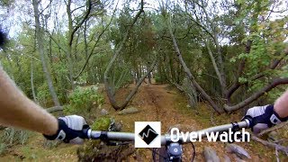
Accessed by Fornminnet and starts at the top of hill by the cairn. Contains some optional drops and a steeper section but nothing crazy. Ends by Eklanda transport that will get you back to Eklanda parking lot.

Local Trail Association

Recent Activity on Trail

Past Week
  • 2 rides
  • 12 miles average
6 Months
  • 18 rides
  • 10 miles avg distance
All
  • 228 rides
  • Last: Jun 16, 2026
c1c2c3c4
January
February
March
April
May
June
July
August
September
October
November
December
update trails status or condition

Overwatch Trail Reports

statusdatedescription
Sep 29, 2024 @ 12:06pm
Sep 29, 2024
Mar 23, 2024 @ 1:56am
Mar 23, 2024
Någon hade lagt en del från en byggställning i sista hällen nedför. Bortplockat men se upp om den kommer tillbaka. Trädet efter är kvar.
Mar 3, 2024 @ 3:38am
Mar 3, 2024
Stora trädet ligger kvar i nedre delen men går nu att ta sig förbi genom att leda cykeln.
Feb 17, 2024 @ 4:10am
Feb 17, 2024
Dec 26, 2023 @ 6:24am
Dec 26, 2023
Large tree down across trail, blocking trail
more »
Status:
on Sep 29, 2024
Ideal
Avg: 3.99 (6 votes)
Your vote: 0

view (2,569)
close
3D
Trail Conditions
  • Unknown
  • Snow Groomed
  • Snow Packed
  • Snow Covered
  • Snow Cover Partial
  • Freeze/thaw Cycle
  • Icy
  • Prevalent Mud
  • Wet
  • Variable
  • Ideal
  • Dry
  • Very Dry
Trail Flow (Ridden Direction)
Trailforks scans users ridelogs to determine the most popular direction each trail is ridden. A good flowing trail network will have most trails flowing in a single direction according to their intension.
The colour categories are based on what percentage of riders are riding a trail in its intended direction.
  • > 96%
  • > 90%
  • > 80%
  • > 70%
  • > 50%
  • < 50%
  • bi-directional trail
  • no data
Trail Last Ridden
Trailforks scans ridelogs to determine the last time a trail was ridden.
  • < 2 days
  • < 1 week
  • < 2 weeks
  • < 1 month
  • < 6 months
  • > 6 months
Trail Ridden Direction
The intended direction a trail should be ridden.
  • Downhill Only
  • Downhill Primary
  • Both Directions
  • Uphill Primary
  • Uphill Only
  • One Direction
Contribute Details
Colors indicate trail is missing specified detail.
  • Description
  • Photos
  • Description & Photos
  • Videos
Trail Popularity ?
Trailforks scans ridelogs to determine which trails are ridden the most in the last 9 months. Trails are compared with nearby trails in the same city region with a possible 25 colour shades. Think of this as a heatmap, more rides = more kinetic energy = warmer colors.
  • most popular
  • popular
  • less popular
  • not popular
ATV/ORV/OHV Filter
Max Vehicle Width
inches
US Cell Coverage
Legend
cell carrier legend

Radar Time
Activity Recordings
Trailforks uses anonymized public activity data. ?
Activity Recordings
Trailforks uses anonymized public activity data. ?
Personal Heatmap
Activity Types
all / none
Options
2
Date range month
Winter Trails
Warning A routing network for winter maps does not exist. Selecting trails using the winter trails layer has been disabled.
Missing Trails
Most Popular
Least Popular
Trails are colored based on popularity. The more popular a trail is, the more red. Less popular trails trend towards green.
Jump Magnitude Heatmap
Heatmap of where riders jump on trails. Zoom in to see individual jumps, click circles to view jump details.
BC Backroad Status

Service Road Atlas is a free to use, community-driven service for viewing and creating reports on the numerous back-country service roads around B.C. and Alberta.

map legend
Slope Aspect
Direction the slope faces
Flat N NE E SE S SW W NW
Trails Deemphasized
Trails are shown in grey.
disable
Only show trails with no bike usage.
Enable
Suggested Layers
Based on selected activity type

    Save the current map location and zoom level as your default home location whenever this page is loaded.

    Save
        Directions to overwatch trailhead (57.655300, 11.973850)

        Photos

        2 more »
        50 |
        Mar 23, 2024 @ 5:17am
        Mar 23, 2024
        39 |
        Dec 26, 2023 @ 6:24am
        Dec 26, 2023

        Videos

        2 more »
        Änggårdsbergen - Overwatch
        0:06 | 750 | Sep 11, 2018 , Göteborg
        'Overwatch'
        0:27 | 178 | Jun 1, 2020 , Göteborg

        Routes with this trail

        5 miles 698 ft 16
        Det här är den svåraste av de markerade, officiella mtb-lederna. Den går mesta dels på röda och...
        3.0 15 miles 1,683 ft 13 Loop
        Göteborgsendurot 2018 Cykeltävling i Änggårdsbergen 14-15 april Detta är en mountainbiketävling som...

        1 Review & Comments


        We hope you've been enjoying Trailforks!

        Create a FREE account to view trail comments and much more.

        • By DoppioTF Pro & contributors
        • #81042 - 1,947 views

        Frequently Asked Questions About Overwatch

        Where is Overwatch located?
        Overwatch is located in Änggårdsbergen, Göteborg, Sweden. It is part of the Änggårdsbergen trail network. The trailhead is located at coordinates 57.6553, 11.97385.
        How hard is Overwatch?
        Overwatch is rated as Black difficulty. The physical rating is Moderate. The average grade is 13.7%.
        What is the elevation gain for Overwatch?
        The trail has 99 ft of elevation descent. The elevation ranges from 133 ft to 232 ft.
        Is Overwatch a point to point trail?
        Yes, Overwatch is a point to point trail. The direction is Downhill Only. The trail type is singletrack.

        Hit the Trail

        Open in App

        Get this trail on your phone instantly.
        open trail in app

        Download Trail

        Save to wishlist, Garmin & download.
        save the trail

        Find Related Routes

        Find routes and users activities that include this trail.
        find routes for this trail

        You must enter a description before submitting.