more stats
1.6 miles
Distance
338 ft
Climb
-40 ft
Descent
00:15:16
Avg time
300 ft
Altitude change
998 ft
Altitude min
1,298 ft
Altitude max
998 ft
Altitude start
1,299 ft
Altitude end
3.6%
Grade
-8%
Grade max
19%
Grade min
1 mile
Distance climb
1,214 ft
Distance down
1,614 ft
Distance flat
00:15:16
Avg time

Owens Run Details

  • Activities
    • Mountain Bike
    • E-Bike
    • Gravel Bike
    • Winter Fat Bike
    • Horse
    • Hike
    • Trail Running
  • Riding Area
  • Difficulty Rating
  • Voted Difficulty
    Blue (1 vote)
  • Local Popularity
    90 in Mountain Biking [+]
    • 90 in E-Biking
    • 70 in Trail Running
    • 60 in Hiking
    • 5 in Horseback
  • Global Ranking
    #56843 in Mountain Biking [+]
    • #15150 in E-Biking
    • #71924 in Trail Running
    • #107004 in Hiking
    • #1215 in Horseback
  • Trail Type
    Singletrack
  • Bike Type
    AM, XC, DJ, Fat, CX, Gravel
  • Direction
    Uphill Primary
    Popular Direction Shown
  • Climb Difficulty
    Green
  • Physical Rating
    Easy
  • Trail Visibility
    Always easy to follow
  • Family Friendly
    Yes
  • Dogs Allowed
    Yes
  • eBike Allowed
    Yes up to Class 1
  • TTFs on Trail
    Berm
  • Year Opened
    2019
  • Land Owner
    BLM

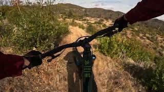
The newest trail in the Swasey Recreation area.
This is a return trail for the Enticer Jump trail, it takes you from the bottom of Enticer back to the top and links in to the Wintu trail just west of the Enticer.
All hand cut singletrack that makes for a nice mellow climb.

Access Info

The bottom of Enticer for going up. Wintu loop a few hundred yards west of the top of Enticer for going down.

Disclaimer

This trail is brand new as of 4/30/19. it is still dry and loose.

Local Trail Association
Traditionally Indigenous Territory

Recent Activity on Trail

Past Week
  • 1 rides
  • 5 miles average
6 Months
  • 101 rides
  • 16 miles avg distance
All
  • 1,028 rides
  • Last: Jun 17, 2026
c1c2c3c4
January
February
March
April
May
June
July
August
September
October
November
December
update trails status or condition

Owens Run Trail Reports

Status:
on Mar 30, 2026
Ideal
Avg: 4.09 (4 votes)
Your vote: 0

view (6,408)
close
3D
Trail Conditions
  • Unknown
  • Snow Groomed
  • Snow Packed
  • Snow Covered
  • Snow Cover Partial
  • Freeze/thaw Cycle
  • Icy
  • Prevalent Mud
  • Wet
  • Variable
  • Ideal
  • Dry
  • Very Dry
Trail Flow (Ridden Direction)
Trailforks scans users ridelogs to determine the most popular direction each trail is ridden. A good flowing trail network will have most trails flowing in a single direction according to their intension.
The colour categories are based on what percentage of riders are riding a trail in its intended direction.
  • > 96%
  • > 90%
  • > 80%
  • > 70%
  • > 50%
  • < 50%
  • bi-directional trail
  • no data
Trail Last Ridden
Trailforks scans ridelogs to determine the last time a trail was ridden.
  • < 2 days
  • < 1 week
  • < 2 weeks
  • < 1 month
  • < 6 months
  • > 6 months
Trail Ridden Direction
The intended direction a trail should be ridden.
  • Downhill Only
  • Downhill Primary
  • Both Directions
  • Uphill Primary
  • Uphill Only
  • One Direction
Contribute Details
Colors indicate trail is missing specified detail.
  • Description
  • Photos
  • Description & Photos
  • Videos
Trail Popularity ?
Trailforks scans ridelogs to determine which trails are ridden the most in the last 9 months. Trails are compared with nearby trails in the same city region with a possible 25 colour shades. Think of this as a heatmap, more rides = more kinetic energy = warmer colors.
  • most popular
  • popular
  • less popular
  • not popular
ATV/ORV/OHV Filter
Max Vehicle Width
inches
US Cell Coverage
Legend
cell carrier legend

Radar Time
Activity Recordings
Trailforks uses anonymized public activity data. ?
Activity Recordings
Trailforks uses anonymized public activity data. ?
Personal Heatmap
Activity Types
all / none
Options
2
Date range month
Winter Trails
Warning A routing network for winter maps does not exist. Selecting trails using the winter trails layer has been disabled.
Missing Trails
Most Popular
Least Popular
Trails are colored based on popularity. The more popular a trail is, the more red. Less popular trails trend towards green.
Jump Magnitude Heatmap
Heatmap of where riders jump on trails. Zoom in to see individual jumps, click circles to view jump details.
BC Backroad Status

Service Road Atlas is a free to use, community-driven service for viewing and creating reports on the numerous back-country service roads around B.C. and Alberta.

map legend
Slope Aspect
Direction the slope faces
Flat N NE E SE S SW W NW
Trails Deemphasized
Trails are shown in grey.
disable
Only show trails with no bike usage.
Enable
Suggested Layers
Based on selected activity type

    Save the current map location and zoom level as your default home location whenever this page is loaded.

    Save
        Directions to owens-run trailhead (40.554710, -122.480030)

        Photos

        1 more »
        60 |
        Mar 30, 2021 @ 6:13pm
        Mar 30, 2021

        Videos

        1 more »
        Owens Run MTB Redding California
        11:53 | 178 | Nov 13, 2024 , Redding

        Routes with this trail

        5.0 34 miles 4,319 ft 14 Race
        The 2026 Lemurian Classic Expert & Pro course. We have eliminated the second time up , but instead...
        3.0 11 miles 1,527 ft 7 Loop
        This Bigfoot Adventure Challenge route is a Bigfoot classic in the BLM managed Swasey Recreation Area near...
        10 miles 1,394 ft 6 Loop
        This intermediate level route from the Swasey Recreation Area Upper Parking Lot is designed to highlight...

        2 Reviews & Comments


        We hope you've been enjoying Trailforks!

        Create a FREE account to view trail comments and much more.

        • By cannonballTF Pro RR & contributors
        • #180925 - 2,478 views

        Frequently Asked Questions About Owens Run

        Where is Owens Run located?
        Owens Run is located in Mule Ridge and Swasey Recreation Area, Redding, California, United States. It is part of the Mule Ridge and Swasey Recreation Area trail network. The trailhead is located at coordinates 40.55471, -122.48003.
        How hard is Owens Run?
        Owens Run is rated as Blue difficulty. The physical rating is Easy. The average grade is 3.6%. The climb difficulty is rated Green.
        What is the elevation gain for Owens Run?
        Owens Run has 103 m of elevation gain. The trail has 12 m of elevation descent. The elevation ranges from 304 m to 396 m.
        Is Owens Run a point to point trail?
        Owens Run is not a point to point trail. The direction is Uphill Primary. The trail type is singletrack.

        Hit the Trail

        Open in App

        Get this trail on your phone instantly.
        open trail in app

        Download Trail

        Save to wishlist, Garmin & download.
        save the trail

        Find Related Routes

        Find routes and users activities that include this trail.
        find routes for this trail

        You must enter a description before submitting.