more stats
1,411 ft
Distance
61 ft
Climb
-168 ft
Descent
00:01:30
Avg time
-107 ft
Altitude change
781 ft
Altitude min
927 ft
Altitude max
902 ft
Altitude start
797 ft
Altitude end
-7.6%
Grade
-47.3%
Grade max
18.3%
Grade min
531 ft
Distance climb
761 ft
Distance down
118 ft
Distance flat
00:01:30
Avg time

Pōhatu (Lower Section) Details

  • Activities
    • Mountain Bike
    • E-Bike
    • Hike
    • Trail Running
  • Riding Area
  • AKA
    North Face Extension
  • Difficulty Rating
  • Voted Difficulty
    Black Diamond (11 votes)
  • Local Popularity
    95 in Mountain Biking [+]
    • 90 in E-Biking
    • 30 in Trail Running
    • 5 in Hiking
  • Global Ranking
    #750 in Mountain Biking [+]
    • #2093 in E-Biking
    • #110915 in Trail Running
    • #121967 in Hiking
  • Hiking SAC Scale
    T1 Hiking
  • Trail Type
    Singletrack
  • Bike Type
    AM, XC
  • Direction
    Downhill Only
    Popular Direction Shown
  • Climb Difficulty
    Blue
  • Physical Rating
    Moderate
  • Trail Visibility
    Always easy to follow
  • Dogs Allowed
    Yes
  • eBike Allowed
    Yes up to Class 1
  • TTFs on Trail
    Berm, Drop, Jump, Rock Face, Rock Garden
  • Year Opened
    2020
  • Land Owner
    Wellington City Council

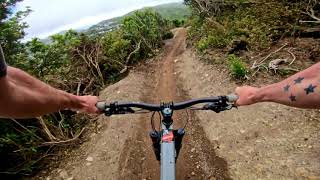
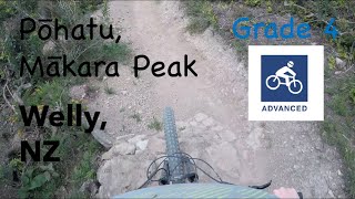
Pōhatu - Te Reo for rocky or stony, due to the massive amount of rock work that went into creating the trail, including armouring the surface, edging the track, creating drops and rock garden features.

This volunteer, hand built singletrack is the last section of the Pōhatu trail ending at Snake Charmer and creating a full Grade 4 descent from the summit to the carpark by continuing into Starfish . It was built by Mākara Peak Supporters and volunteers during 2020, beginning before the first COVID-19 lockdown.

It's starts off in a similar style as Starfish, with some small drops, catch berms and a bit of enduro-flow. After exiting the native bush onto an exposed ridge, things start getting steeper, the drops bigger and the fun factor ramps up. An enormous amount of rock was sourced from the surrounding hillside and used to armour the track, build the berms, edge the track, and create a series of rock garden features in the final 100m of track.

Disclaimer

Some parts still under construction. Ride with caution. Look out for trail builders.

Local Trail Association

Recent Activity on Trail

Past Week
  • 6 rides
  • 17.8 km average
6 Months
  • 180 rides
  • 20.2 km avg distance
All
  • 1,839 rides
  • Last: Jun 17, 2026
c1c2c3c4
January
February
March
April
May
June
July
August
September
October
November
December
update trails status or condition

Pōhatu (Lower... Trail Reports

statusdatedescription
Apr 7, 2026 @ 8:16am (Pacific/Auckland)
Apr 6, 2026
reporter
Low points filled and drains cleared to help water get off trail surface quickly. A bit soft in places. Gorse & barberry cut back down open...
Apr 1, 2026 @ 6:23am (Pacific/Auckland)
Mar 31, 2026
reporter
Vegetation cut back to improve sight lines, drains cleared of silt, puddles filled with local soil. Surface raked. Got as far as RH switchback.
Mar 8, 2026 @ 8:26am (Pacific/Auckland)
Mar 7, 2026
Mar 1, 2026 @ 10:51am (Pacific/Auckland)
Feb 28, 2026
Jan 21, 2026 @ 4:30pm (Pacific/Auckland)
Jan 20, 2026
more »
Status:
on Apr 7, 2026
Dry
Avg: 4.65 (20 votes)
Your vote: 0

view (18,314)
close
3D
Trail Conditions
  • Unknown
  • Snow Groomed
  • Snow Packed
  • Snow Covered
  • Snow Cover Partial
  • Freeze/thaw Cycle
  • Icy
  • Prevalent Mud
  • Wet
  • Variable
  • Ideal
  • Dry
  • Very Dry
Trail Flow (Ridden Direction)
Trailforks scans users ridelogs to determine the most popular direction each trail is ridden. A good flowing trail network will have most trails flowing in a single direction according to their intension.
The colour categories are based on what percentage of riders are riding a trail in its intended direction.
  • > 96%
  • > 90%
  • > 80%
  • > 70%
  • > 50%
  • < 50%
  • bi-directional trail
  • no data
Trail Last Ridden
Trailforks scans ridelogs to determine the last time a trail was ridden.
  • < 2 days
  • < 1 week
  • < 2 weeks
  • < 1 month
  • < 6 months
  • > 6 months
Trail Ridden Direction
The intended direction a trail should be ridden.
  • Downhill Only
  • Downhill Primary
  • Both Directions
  • Uphill Primary
  • Uphill Only
  • One Direction
Contribute Details
Colors indicate trail is missing specified detail.
  • Description
  • Photos
  • Description & Photos
  • Videos
Trail Popularity ?
Trailforks scans ridelogs to determine which trails are ridden the most in the last 9 months. Trails are compared with nearby trails in the same city region with a possible 25 colour shades. Think of this as a heatmap, more rides = more kinetic energy = warmer colors.
  • most popular
  • popular
  • less popular
  • not popular
ATV/ORV/OHV Filter
Max Vehicle Width
inches
US Cell Coverage
Legend
cell carrier legend

Radar Time
Activity Recordings
Trailforks uses anonymized public activity data. ?
Activity Recordings
Trailforks uses anonymized public activity data. ?
Personal Heatmap
Activity Types
all / none
Options
2
Date range month
Winter Trails
Warning A routing network for winter maps does not exist. Selecting trails using the winter trails layer has been disabled.
Missing Trails
Most Popular
Least Popular
Trails are colored based on popularity. The more popular a trail is, the more red. Less popular trails trend towards green.
Jump Magnitude Heatmap
Heatmap of where riders jump on trails. Zoom in to see individual jumps, click circles to view jump details.
BC Backroad Status

Service Road Atlas is a free to use, community-driven service for viewing and creating reports on the numerous back-country service roads around B.C. and Alberta.

map legend
Slope Aspect
Direction the slope faces
Flat N NE E SE S SW W NW
Trails Deemphasized
Trails are shown in grey.
disable
Only show trails with no bike usage.
Enable
Suggested Layers
Based on selected activity type

    Save the current map location and zoom level as your default home location whenever this page is loaded.

    Save
        Directions to p-hatu-lower-section trailhead (-41.292180, 174.715370)

        Photos

        14 more »
        25 |
        Apr 6, 2026 @ 1:13pm
        Apr 6, 2026
        27 |
        Apr 6, 2026 @ 1:13pm
        Apr 6, 2026
        64 |
        Jul 22, 2022 @ 8:04pm
        Jul 22, 2022
        82 |
        Nov 6, 2020 @ 11:36am
        Nov 6, 2020

        Videos

        6 more »
        youtuber NEW ROCKY FLOW - Pōhatu Mountain Bike Trail...
        0:36 | 738 | Feb 21, 2021 , Wellington
        youtuber Pohatu(NEW!!!) @ Makara Peak MTB Park
        0:33 | 826 | Dec 24, 2020 , Wellington
        Pōhatu | Mākara Peak Mountain bike Park |...
        2:01 | 154 | Nov 20, 2021 , Wellington
        Pōhatu - Mākara Peak
        2:18 | 214 | Sep 19, 2021 , Wellington

        Routes with this trail

        35 miles 7,069 ft 32 Loop
        From Johnsonville train station to Underworld Tavern the long way around. This route connects the main...
        43 miles 9,985 ft 32 Loop
        An intermediate - advanced 70 kilometre mission around a majority of the trails in Makara. Good training...

        6 Reviews & Comments


        We hope you've been enjoying Trailforks!

        Create a FREE account to view trail comments and much more.

        Frequently Asked Questions About Pōhatu (Lower Section)

        Where is Pōhatu (Lower Section) located?
        Pōhatu (Lower Section) is located in Mākara Peak Mountain Bike Park, Wellington, New Zealand. It is part of the Mākara Peak Mountain Bike Park trail network. The trailhead is located at coordinates -41.29218, 174.71537.
        How hard is Pōhatu (Lower Section)?
        Pōhatu (Lower Section) is rated as Advanced difficulty. The physical rating is Moderate. The average grade is 7.6%. The climb difficulty is rated Blue.
        What is the elevation gain for Pōhatu (Lower Section)?
        Pōhatu (Lower Section) has 61 ft of elevation gain. The trail has 168 ft of elevation descent. The elevation ranges from 781 ft to 927 ft.
        Is Pōhatu (Lower Section) a point to point trail?
        Yes, Pōhatu (Lower Section) is a point to point trail. The direction is Downhill Only. The trail type is singletrack.

        Hit the Trail

        Open in App

        Get this trail on your phone instantly.
        open trail in app

        Download Trail

        Save to wishlist, Garmin & download.
        save the trail

        Find Related Routes

        Find routes and users activities that include this trail.
        find routes for this trail

        You must enter a description before submitting.