more stats
1,795 ft
Distance
72 ft
Climb
-239 ft
Descent
00:01:45
Avg time
-166 ft
Altitude change
957 ft
Altitude min
1,132 ft
Altitude max
1,132 ft
Altitude start
965 ft
Altitude end
-9.3%
Grade
-45.5%
Grade max
37.7%
Grade min
564 ft
Distance climb
971 ft
Distance down
256 ft
Distance flat
00:01:45
Avg time

Pōhatu (Middle Section) Details

  • Activities
    • Mountain Bike
    • E-Bike
    • Hike
    • Trail Running
  • Riding Area
  • Difficulty Rating
  • Voted Difficulty
    Black Diamond (7 votes)
  • Local Popularity
    95 in Mountain Biking [+]
    • 95 in E-Biking
    • 30 in Trail Running
    • 50 in Hiking
  • Global Ranking
    #247 in Mountain Biking [+]
    • #2500 in E-Biking
    • #116249 in Trail Running
    • #96196 in Hiking
  • Trail Type
    Singletrack
  • Bike Type
    AM
  • Direction
    Downhill Only
    Popular Direction Shown
  • Climb Difficulty
    Blue
  • Physical Rating
    Hard
  • Trail Visibility
    Always easy to follow
  • eBike Allowed
    Yes up to Class 1
  • TTFs on Trail
    Berm, Drop, Jump, Rock Face, Rock Garden
  • Year Opened
    2022
  • Land Owner
    Wellington City Council

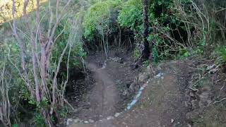
The "middle section" of Pōhatu continues the fun from "upper" Pōhatu after crossing North Face. It becomes a bit steeper and more techy than the upper section.

Planned and managed by Mākara Peak Supporters, crafted by TGL Contracting and funded by Trails Wellington.

It connects back in near the bottom of North Face before heading into the lower Pōhatu section.

Trail Supporters
Local Trail Association

Recent Activity on Trail

Past Week
  • 3 rides
  • 13 miles average
6 Months
  • 192 rides
  • 13 miles avg distance
All
  • 1,509 rides
  • Last: Jun 6, 2026
c1c2c3c4
January
February
March
April
May
June
July
August
September
October
November
December
update trails status or condition

Pōhatu (Middle... Trail Reports

Status:
on May 30, 2026
Variable
Avg: 4.52 (12 votes)
Your vote: 0

view (12,505)
close
3D
Trail Conditions
  • Unknown
  • Snow Groomed
  • Snow Packed
  • Snow Covered
  • Snow Cover Partial
  • Freeze/thaw Cycle
  • Icy
  • Prevalent Mud
  • Wet
  • Variable
  • Ideal
  • Dry
  • Very Dry
Trail Flow (Ridden Direction)
Trailforks scans users ridelogs to determine the most popular direction each trail is ridden. A good flowing trail network will have most trails flowing in a single direction according to their intension.
The colour categories are based on what percentage of riders are riding a trail in its intended direction.
  • > 96%
  • > 90%
  • > 80%
  • > 70%
  • > 50%
  • < 50%
  • bi-directional trail
  • no data
Trail Last Ridden
Trailforks scans ridelogs to determine the last time a trail was ridden.
  • < 2 days
  • < 1 week
  • < 2 weeks
  • < 1 month
  • < 6 months
  • > 6 months
Trail Ridden Direction
The intended direction a trail should be ridden.
  • Downhill Only
  • Downhill Primary
  • Both Directions
  • Uphill Primary
  • Uphill Only
  • One Direction
Contribute Details
Colors indicate trail is missing specified detail.
  • Description
  • Photos
  • Description & Photos
  • Videos
Trail Popularity ?
Trailforks scans ridelogs to determine which trails are ridden the most in the last 9 months. Trails are compared with nearby trails in the same city region with a possible 25 colour shades. Think of this as a heatmap, more rides = more kinetic energy = warmer colors.
  • most popular
  • popular
  • less popular
  • not popular
ATV/ORV/OHV Filter
Max Vehicle Width
inches
US Cell Coverage
Legend
cell carrier legend

Radar Time
Activity Recordings
Trailforks uses anonymized public activity data. ?
Activity Recordings
Trailforks uses anonymized public activity data. ?
Personal Heatmap
Activity Types
all / none
Options
2
Date range month
Winter Trails
Warning A routing network for winter maps does not exist. Selecting trails using the winter trails layer has been disabled.
Missing Trails
Most Popular
Least Popular
Trails are colored based on popularity. The more popular a trail is, the more red. Less popular trails trend towards green.
Jump Magnitude Heatmap
Heatmap of where riders jump on trails. Zoom in to see individual jumps, click circles to view jump details.
BC Backroad Status

Service Road Atlas is a free to use, community-driven service for viewing and creating reports on the numerous back-country service roads around B.C. and Alberta.

map legend
Slope Aspect
Direction the slope faces
Flat N NE E SE S SW W NW
Trails Deemphasized
Trails are shown in grey.
disable
Only show trails with no bike usage.
Enable
Suggested Layers
Based on selected activity type

    Save the current map location and zoom level as your default home location whenever this page is loaded.
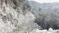
    Save
        Directions to p-hatu-middle-section trailhead (-41.290270, 174.710770)

        Photos

        2 more »
        87 |
        Apr 16, 2023 @ 7:46pm
        Apr 16, 2023
        87 |
        Apr 16, 2023 @ 7:46pm
        Apr 16, 2023
        79 |
        Mar 2, 2022 @ 2:45pm
        Mar 2, 2022
        69 |
        Mar 2, 2022 @ 2:45pm
        Mar 2, 2022

        Videos

        6 more »
        August 2022 First ride on Middle Pohatu,...
        5:01 | 370 | Aug 14, 2022 , Wellington
        youtuber Middle Pohatu | Makara's PERFECT mix of...
        0:45 | 335 | Jul 23, 2022 , Wellington
        youtuber !!!BRAND NEW!!! Middle of Pōhatu @ Makara...
        0:46 | 343 | May 7, 2022 , Wellington
        Huge FRONTFLIP after pedal clip.
        0:06 | 322 | May 24, 2022 , Wellington

        Routes with this trail

        35 miles 7,069 ft 32 Loop
        From Johnsonville train station to Underworld Tavern the long way around. This route connects the main...
        7 miles 1,873 ft 9 Loop
        An intermediate loop to the summit and back down

        6 Reviews & Comments


        We hope you've been enjoying Trailforks!

        Create a FREE account to view trail comments and much more.

        Frequently Asked Questions About Pōhatu (Middle Section)

        Where is Pōhatu (Middle Section) located?
        Pōhatu (Middle Section) is located in Mākara Peak Mountain Bike Park, Wellington, New Zealand. It is part of the Mākara Peak Mountain Bike Park trail network. The trailhead is located at coordinates -41.29027, 174.71077.
        How hard is Pōhatu (Middle Section)?
        Pōhatu (Middle Section) is rated as Advanced difficulty. The physical rating is Hard. The average grade is 9.3%. The climb difficulty is rated Blue.
        What is the elevation gain for Pōhatu (Middle Section)?
        Pōhatu (Middle Section) has 72 ft of elevation gain. The trail has 239 ft of elevation descent. The elevation ranges from 957 ft to 1,132 ft.
        Is Pōhatu (Middle Section) a point to point trail?
        Yes, Pōhatu (Middle Section) is a point to point trail. The direction is Downhill Only. The trail type is singletrack.

        Hit the Trail

        Open in App

        Get this trail on your phone instantly.
        open trail in app

        Download Trail

        Save to wishlist, Garmin & download.
        save the trail

        Find Related Routes

        Find routes and users activities that include this trail.
        find routes for this trail

        You must enter a description before submitting.