more stats
2,303 ft
Distance
22 ft
Climb
-163 ft
Descent
00:02:31
Avg time
-141 ft
Altitude change
1,149 ft
Altitude min
1,302 ft
Altitude max
1,302 ft
Altitude start
1,161 ft
Altitude end
-6.1%
Grade
-27%
Grade max
22.9%
Grade min
190 ft
Distance climb
1,841 ft
Distance down
272 ft
Distance flat
00:02:31
Avg time

Pōhatu (Upper Section) Details

  • Activities
    • Mountain Bike
    • E-Bike
  • Riding Area
  • AKA
    Pōhatu
  • Difficulty Rating
  • Voted Difficulty
    Blue (4 votes)
  • Global Ranking
    #34675 in Mountain Biking [+]
    • #103693 in E-Biking
  • Trail Type
    Singletrack
  • Bike Type
    AM
  • Direction
    Downhill Only
    Popular Direction Shown
  • Climb Difficulty
    Blue
  • Physical Rating
    Moderate
  • Trail Visibility
    Always easy to follow
  • Dogs Allowed
    Yes
  • eBike Allowed
    Yes up to Class 1
  • TTFs on Trail
    Berm, Drop, Jump, Gap Jump
  • Year Opened
    2022
  • Land Owner
    Wellington City Council

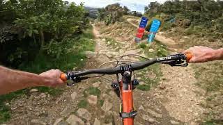
Pōhatu (Upper Section) starts at the summit of Mākara Peak, sharing the same riding corridor with the start of Ridgeline, before branching left and down towards North Face.

It's quite wide, and probably easier than the middle and lower sections of Pōhatu, so a good option for riders wanting to try out a grade 4 trail. There are quite a few lips and hips that can be boosted by capable shredders, or rolled if you prefer to keep your tyres on the dirt.

Local Trail Association

Recent Activity on Trail

Past Week
  • 4 rides
  • 13 miles average
6 Months
  • 170 rides
  • 13 miles avg distance
All
  • 1,072 rides
  • Last: Jun 14, 2026
c1c2c3c4
January
February
March
April
May
June
July
August
September
October
November
December
update trails status or condition

Pōhatu (Upper... Trail Reports

Status:
on May 30, 2026
Variable
Avg: 4.41 (12 votes)
Your vote: 0

view (1)
close
3D
Trail Conditions
  • Unknown
  • Snow Groomed
  • Snow Packed
  • Snow Covered
  • Snow Cover Partial
  • Freeze/thaw Cycle
  • Icy
  • Prevalent Mud
  • Wet
  • Variable
  • Ideal
  • Dry
  • Very Dry
Trail Flow (Ridden Direction)
Trailforks scans users ridelogs to determine the most popular direction each trail is ridden. A good flowing trail network will have most trails flowing in a single direction according to their intension.
The colour categories are based on what percentage of riders are riding a trail in its intended direction.
  • > 96%
  • > 90%
  • > 80%
  • > 70%
  • > 50%
  • < 50%
  • bi-directional trail
  • no data
Trail Last Ridden
Trailforks scans ridelogs to determine the last time a trail was ridden.
  • < 2 days
  • < 1 week
  • < 2 weeks
  • < 1 month
  • < 6 months
  • > 6 months
Trail Ridden Direction
The intended direction a trail should be ridden.
  • Downhill Only
  • Downhill Primary
  • Both Directions
  • Uphill Primary
  • Uphill Only
  • One Direction
Contribute Details
Colors indicate trail is missing specified detail.
  • Description
  • Photos
  • Description & Photos
  • Videos
Trail Popularity ?
Trailforks scans ridelogs to determine which trails are ridden the most in the last 9 months. Trails are compared with nearby trails in the same city region with a possible 25 colour shades. Think of this as a heatmap, more rides = more kinetic energy = warmer colors.
  • most popular
  • popular
  • less popular
  • not popular
ATV/ORV/OHV Filter
Max Vehicle Width
inches
US Cell Coverage
Legend
cell carrier legend

Radar Time
Activity Recordings
Trailforks uses anonymized public activity data. ?
Activity Recordings
Trailforks uses anonymized public activity data. ?
Personal Heatmap
Activity Types
all / none
Options
2
Date range month
Winter Trails
Warning A routing network for winter maps does not exist. Selecting trails using the winter trails layer has been disabled.
Missing Trails
Most Popular
Least Popular
Trails are colored based on popularity. The more popular a trail is, the more red. Less popular trails trend towards green.
Jump Magnitude Heatmap
Heatmap of where riders jump on trails. Zoom in to see individual jumps, click circles to view jump details.
BC Backroad Status

Service Road Atlas is a free to use, community-driven service for viewing and creating reports on the numerous back-country service roads around B.C. and Alberta.

map legend
Slope Aspect
Direction the slope faces
Flat N NE E SE S SW W NW
Trails Deemphasized
Trails are shown in grey.
disable
Only show trails with no bike usage.
Enable
Suggested Layers
Based on selected activity type

    Save the current map location and zoom level as your default home location whenever this page is loaded.

    Save
        Directions to p-hatu-upper-section trailhead (-41.288640, 174.707310)

        Photos

        16 more »
        36 |
        Apr 13, 2025 @ 3:03pm
        Apr 13, 2025
        28 |
        Apr 13, 2025 @ 3:03pm
        Apr 13, 2025
        28 |
        Apr 13, 2025 @ 3:03pm
        Apr 13, 2025
        29 |
        Apr 13, 2025 @ 3:03pm
        Apr 13, 2025

        Videos

        7 more »
        youtuber Pohatu @ Makara Peak MTB Park
        5:06 | 259 | Jun 24, 2024 , Wellington
        youtuber Back in Wellington, Pohatu Trail, New Zealand
        3:49 | 241 | Dec 26, 2022 , Wellington
        youtuber Full Pōhatu |  The wait is FINALLY over!
        4:55 | 418 | Jan 3, 2023 , Wellington
        youtuber Upper Pōhatu *BRAND NEW* @ Makara Peak MTB...
        2:18 | 278 | Dec 25, 2022 , Wellington

        Routes with this trail

        35 miles 7,069 ft 32 Loop
        From Johnsonville train station to Underworld Tavern the long way around. This route connects the main...
        63 miles 10,878 ft 40 Point to Point Race
        Enjoy the best trails surrounding any city in the world! Incredible views, diverse trails and landscapes...

        3 Reviews & Comments


        We hope you've been enjoying Trailforks!

        Create a FREE account to view trail comments and much more.

        Frequently Asked Questions About Pōhatu (Upper Section)

        Where is Pōhatu (Upper Section) located?
        Pōhatu (Upper Section) is located in Mākara Peak Mountain Bike Park, Wellington, New Zealand. It is part of the Mākara Peak Mountain Bike Park trail network. The trailhead is located at coordinates -41.28864, 174.70731.
        How hard is Pōhatu (Upper Section)?
        Pōhatu (Upper Section) is rated as Advanced difficulty. The physical rating is Moderate. The average grade is 6.1%. The climb difficulty is rated Blue.
        What is the elevation gain for Pōhatu (Upper Section)?
        Pōhatu (Upper Section) has 22 ft of elevation gain. The trail has 163 ft of elevation descent. The elevation ranges from 1,149 ft to 1,302 ft.
        Is Pōhatu (Upper Section) a point to point trail?
        Yes, Pōhatu (Upper Section) is a point to point trail. The direction is Downhill Only. The trail type is singletrack.

        Hit the Trail

        Open in App

        Get this trail on your phone instantly.
        open trail in app

        Download Trail

        Save to wishlist, Garmin & download.
        save the trail

        Find Related Routes

        Find routes and users activities that include this trail.
        find routes for this trail

        You must enter a description before submitting.