more stats
1.4 miles
Distance
65 ft
Climb
-452 ft
Descent
00:06:32
Avg time
-386 ft
Altitude change
400 ft
Altitude min
802 ft
Altitude max
797 ft
Altitude start
410 ft
Altitude end
-5.3%
Grade
-20.8%
Grade max
16.8%
Grade min
1,447 ft
Distance climb
1 mile
Distance down
190 ft
Distance flat
00:06:32
Avg time

P51 Details

  • Activities
    • Mountain Bike
    • E-Bike
    • Winter Fat Bike
  • Riding Area
    Codgers
    Nelson
  • Difficulty Rating
  • Voted Difficulty
    Blue (4 votes)
  • Local Popularity
    85 in Mountain Biking [+]
    • 95 in E-Biking
  • Global Ranking
    #11476 in Mountain Biking [+]
    • #2135 in E-Biking
  • Trail Type
    Singletrack
  • Bike Type
    AM, XC, Fat
  • Direction
    Downhill Only
    Popular Direction Shown
  • Climb Difficulty
    Blue
  • Physical Rating
    Moderate
  • Season
    All Year
  • Dogs Allowed
    Yes
  • eBike Allowed
    Yes up to Class 1
  • TTFs on Trail
    Berm, Jump
  • Year Opened
    2018

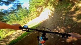
Rebuilt in March 2018 this flowing singletrack is part flow trail and part old school.
Some fun little jumps and berms, with some more mellow sections. firball.
New trail grade in 2021

Access Info

From the forestry road that dissects Firbal (Middle Road), continue west up a small rise to "Little Skid" site, then either enter the trail there,(follow signs) or ride up "Whanake" to enter the trail at the very top (recommended)

Trail Supporters
  • past supporters

  • Tonkin Taylor
    2018 - 2020
    Sponsor

Recent Activity on Trail

Past Week
  • 1 rides
  • 13.0 km average
6 Months
  • 46 rides
  • 18.8 km avg distance
All
  • 397 rides
  • Last: Jun 16, 2026
c1c2c3c4
January
February
March
April
May
June
July
August
September
October
November
December
update trails status or condition

P51 Trail Reports

statusdatedescription
Mar 16, 2026 @ 10:37am (Pacific/Auckland)
Mar 15, 2026
reporter
Mar 9, 2026 @ 6:47pm (Pacific/Auckland)
Mar 8, 2026
reporter Closed from 8am until 5pm Mon 9th - 13th.
Jan 3, 2026 @ 6:42pm (Pacific/Auckland)
Jan 2, 2026
reporter Trees and debris cleared. Great condition.
Jan 2, 2026 @ 6:34am (Pacific/Auckland)
Jan 1, 2026
Post storm debris and circa 6+ trees down on and some across the trail. Recommend avoiding P51
Dec 31, 2025 @ 5:17pm (Pacific/Auckland)
Dec 30, 2025
3-4 trees down and a few more part blocking.
more »
Status:
on Mar 16, 2026
Avg: 4.12 (35 votes)
Your vote: 0

view (5,723)
close
3D
Trail Conditions
  • Unknown
  • Snow Groomed
  • Snow Packed
  • Snow Covered
  • Snow Cover Partial
  • Freeze/thaw Cycle
  • Icy
  • Prevalent Mud
  • Wet
  • Variable
  • Ideal
  • Dry
  • Very Dry
Trail Flow (Ridden Direction)
Trailforks scans users ridelogs to determine the most popular direction each trail is ridden. A good flowing trail network will have most trails flowing in a single direction according to their intension.
The colour categories are based on what percentage of riders are riding a trail in its intended direction.
  • > 96%
  • > 90%
  • > 80%
  • > 70%
  • > 50%
  • < 50%
  • bi-directional trail
  • no data
Trail Last Ridden
Trailforks scans ridelogs to determine the last time a trail was ridden.
  • < 2 days
  • < 1 week
  • < 2 weeks
  • < 1 month
  • < 6 months
  • > 6 months
Trail Ridden Direction
The intended direction a trail should be ridden.
  • Downhill Only
  • Downhill Primary
  • Both Directions
  • Uphill Primary
  • Uphill Only
  • One Direction
Contribute Details
Colors indicate trail is missing specified detail.
  • Description
  • Photos
  • Description & Photos
  • Videos
Trail Popularity ?
Trailforks scans ridelogs to determine which trails are ridden the most in the last 9 months. Trails are compared with nearby trails in the same city region with a possible 25 colour shades. Think of this as a heatmap, more rides = more kinetic energy = warmer colors.
  • most popular
  • popular
  • less popular
  • not popular
ATV/ORV/OHV Filter
Max Vehicle Width
inches
US Cell Coverage
Legend
cell carrier legend

Radar Time
Activity Recordings
Trailforks uses anonymized public activity data. ?
Activity Recordings
Trailforks uses anonymized public activity data. ?
Personal Heatmap
Activity Types
all / none
Options
2
Date range month
Winter Trails
Warning A routing network for winter maps does not exist. Selecting trails using the winter trails layer has been disabled.
Missing Trails
Most Popular
Least Popular
Trails are colored based on popularity. The more popular a trail is, the more red. Less popular trails trend towards green.
Jump Magnitude Heatmap
Heatmap of where riders jump on trails. Zoom in to see individual jumps, click circles to view jump details.
BC Backroad Status

Service Road Atlas is a free to use, community-driven service for viewing and creating reports on the numerous back-country service roads around B.C. and Alberta.

map legend
Slope Aspect
Direction the slope faces
Flat N NE E SE S SW W NW
Trails Deemphasized
Trails are shown in grey.
disable
Only show trails with no bike usage.
Enable
Suggested Layers
Based on selected activity type

    Save the current map location and zoom level as your default home location whenever this page is loaded.

    Save
        Directions to p51 trailhead (-41.287540, 173.298770)

        Photos

        13 more »
        216 |
        Jan 31, 2019 @ 7:08pm
        Jan 31, 2019
        119 |
        Dec 29, 2018 @ 4:06pm
        Dec 29, 2018
        214 |
        Mar 16, 2018 @ 1:50am
        Mar 16, 2018
        22 |
        Dec 30, 2025 @ 8:17pm
        Dec 30, 2025

        Videos

        9 more »
        youtuber P51 @ Codgers Trail Park. Nelson
        5:21 | 377 | Jan 23, 2023 , Nelson
        youtuber CLASSIC NELSON FLOW - P51 Mountain Bike Trail...
        4:52 | 564 | Jan 11, 2021 , Nelson
        Re-Built P51 Flowy, smooth and all groomed up
        5:10 | 77 | Aug 7, 2024 , Nelson
        Flowy Christmas run on P51 - Codgers MTB Park,...
        5:25 | 171 | Dec 23, 2022 , Nelson

        9 Reviews & Comments


        We hope you've been enjoying Trailforks!

        Create a FREE account to view trail comments and much more.

        • By NMTBCTF Pro NMTBC & contributors
        • #36960 - 11,109 views

        Frequently Asked Questions About P51

        Where is P51 located?
        P51 is located in Codgers, Nelson, New Zealand. It is part of the Codgers trail network. The trailhead is located at coordinates -41.28754, 173.29877.
        How hard is P51?
        P51 is rated as Advanced difficulty. The physical rating is Moderate. The average grade is 5.3%. The climb difficulty is rated Blue.
        What is the elevation gain for P51?
        P51 has 20 m of elevation gain. The trail has 138 m of elevation descent. The elevation ranges from 122 m to 245 m.
        Is P51 a point to point trail?
        Yes, P51 is a point to point trail. The direction is Downhill Only. The trail type is singletrack.

        Hit the Trail

        Open in App

        Get this trail on your phone instantly.
        open trail in app

        Download Trail

        Save to wishlist, Garmin & download.
        save the trail

        Find Related Routes

        Find routes and users activities that include this trail.
        find routes for this trail

        You must enter a description before submitting.