more stats
4,396 ft
Distance
76 ft
Climb
-937 ft
Descent
00:19:53
Avg time
-861 ft
Altitude change
11,156 ft
Altitude min
12,017 ft
Altitude max
12,017 ft
Altitude start
11,155 ft
Altitude end
-19.6%
Grade
-65.2%
Grade max
22.1%
Grade min
650 ft
Distance climb
3,638 ft
Distance down
108 ft
Distance flat
00:19:53
Avg time

Pablo Honey Details

  • Activities
    • Mountain Bike
    • E-Bike
  • Riding Area
  • Difficulty Rating
  • Voted Difficulty
    Double Black Diamond (2 votes)
  • Local Popularity
    25 in Mountain Biking [+]
    • 20 in E-Biking
  • Global Ranking
    #110652 in Mountain Biking [+]
    • #99419 in E-Biking
  • Trail Type
    Singletrack
  • Bike Type
    DH, AM
  • Direction
    Downhill Only
    Popular Direction Shown
  • Climb Difficulty
    Black Diamond
  • Physical Rating
    Hard
  • Trail Visibility
    Always easy to follow
  • Dogs Allowed
    Yes
  • eBike Allowed
    Yes up to Class 1
  • TTFs on Trail
    Berm, Drop, Ladder Bridge
  • Land Owner
    COMUNIDAD SAN MATEO TLALTENANGO

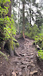
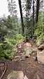
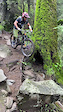
Un trail que necesitas pedalear 2 hrs aproximadamente para llegar, el inicio es la parte más técnica pues tiene una bajada muy pronunciada, después todo se convierte en diversión pues esta llena de switch back y algunos drops , tiene sus repechos , tiene bajadas con madera y un puente de madera muy divertido.

Trail Supporters
Traditionally Indigenous Territory

Recent Activity on Trail

Past Week
  • 0 rides
  •  
6 Months
  • 2 rides
  • 11 miles avg distance
All
  • 44 rides
  • Last: Mar 13, 2026
c1c2c3c4
January
February
March
April
May
June
July
August
September
October
November
December
update trails status or condition

Pablo Honey Trail Reports

statusdatedescription
Nov 16, 2024 @ 12:08pm
Nov 16, 2024
Puente en el 1/4 roto. La bajada 3/4 está muy wena.
Apr 7, 2024 @ 12:31pm
Apr 7, 2024
Jan 3, 2024 @ 2:28am
Jan 3, 2024
Puente roto.
Jun 24, 2022 @ 9:19am
Jun 24, 2022
De lujo! Poco patinozas la zona de piedras
Feb 23, 2022 @ 7:59am
Feb 23, 2022
Muy seca de 1/2 Pablo para abajo
more »
Status:
on Nov 16, 2024
Dry
Avg: 4.53 (7 votes)
Your vote: 0

view (212)
close
3D
Trail Conditions
  • Unknown
  • Snow Groomed
  • Snow Packed
  • Snow Covered
  • Snow Cover Partial
  • Freeze/thaw Cycle
  • Icy
  • Prevalent Mud
  • Wet
  • Variable
  • Ideal
  • Dry
  • Very Dry
Trail Flow (Ridden Direction)
Trailforks scans users ridelogs to determine the most popular direction each trail is ridden. A good flowing trail network will have most trails flowing in a single direction according to their intension.
The colour categories are based on what percentage of riders are riding a trail in its intended direction.
  • > 96%
  • > 90%
  • > 80%
  • > 70%
  • > 50%
  • < 50%
  • bi-directional trail
  • no data
Trail Last Ridden
Trailforks scans ridelogs to determine the last time a trail was ridden.
  • < 2 days
  • < 1 week
  • < 2 weeks
  • < 1 month
  • < 6 months
  • > 6 months
Trail Ridden Direction
The intended direction a trail should be ridden.
  • Downhill Only
  • Downhill Primary
  • Both Directions
  • Uphill Primary
  • Uphill Only
  • One Direction
Contribute Details
Colors indicate trail is missing specified detail.
  • Description
  • Photos
  • Description & Photos
  • Videos
Trail Popularity ?
Trailforks scans ridelogs to determine which trails are ridden the most in the last 9 months. Trails are compared with nearby trails in the same city region with a possible 25 colour shades. Think of this as a heatmap, more rides = more kinetic energy = warmer colors.
  • most popular
  • popular
  • less popular
  • not popular
ATV/ORV/OHV Filter
Max Vehicle Width
inches
US Cell Coverage
Legend
cell carrier legend

Radar Time
Activity Recordings
Trailforks uses anonymized public activity data. ?
Activity Recordings
Trailforks uses anonymized public activity data. ?
Personal Heatmap
Activity Types
all / none
Options
2
Date range month
Winter Trails
Warning A routing network for winter maps does not exist. Selecting trails using the winter trails layer has been disabled.
Missing Trails
Most Popular
Least Popular
Trails are colored based on popularity. The more popular a trail is, the more red. Less popular trails trend towards green.
Jump Magnitude Heatmap
Heatmap of where riders jump on trails. Zoom in to see individual jumps, click circles to view jump details.
BC Backroad Status

Service Road Atlas is a free to use, community-driven service for viewing and creating reports on the numerous back-country service roads around B.C. and Alberta.

map legend
Slope Aspect
Direction the slope faces
Flat N NE E SE S SW W NW
Trails Deemphasized
Trails are shown in grey.
disable
Only show trails with no bike usage.
Enable
Suggested Layers
Based on selected activity type

    Save the current map location and zoom level as your default home location whenever this page is loaded.

    Save
        Directions to pablo-honey trailhead (19.271140, -99.323880)

        Photos

        19 more »
        472 |
        Jul 18, 2020 @ 11:54pm
        Jul 18, 2020
        63 |
        Jul 16, 2025 @ 9:06am
        Jul 16, 2025
        172 |
        Jul 19, 2020 @ 12:15am
        Jul 19, 2020
        204 |
        Jul 19, 2020 @ 12:15am
        Jul 19, 2020

        Videos

        7 more »
        youtuber ????????ADVENTURE! 'should we be here after...
        36:08 | 509 | Mar 5, 2020 , Cuajimalpa
        Losing grip
        0:11 | 153 | Aug 15, 2022 , Cuajimalpa
        Steep technical section in Pablo's Honey trail
        0:08 | 171 | Aug 15, 2022 , Cuajimalpa
        Steep technical section in Pablo's Honey trail
        0:08 | 191 | Aug 15, 2022 , Cuajimalpa

        Routes with this trail

        5.0 16 miles 3,648 ft 44 Point to Point Race
        Evento de la Final del serial Intense MTB Enduro Series 2018 PE 1 PE 2 DH PE 3 DH 1/2 PE 4 Mirador...

        Reviews / Comments

        No reviews yet, be the first to write a review or ask a question.
        Use trail reports to comment on trail conditions.


        We hope you've been enjoying Trailforks!

        Create a FREE account to view trail comments and much more.

        • By eriks-custom-garage & contributors
        • #76784 - 5,758 views

        Frequently Asked Questions About Pablo Honey

        Where is Pablo Honey located?
        Pablo Honey is located in Desierto De Los Leones, Cuajimalpa, México. It is part of the Desierto De Los Leones trail network. The trailhead is located at coordinates 19.27114, -99.32388.
        How hard is Pablo Honey?
        Pablo Honey is rated as Black Diamond difficulty. The physical rating is Hard. The average grade is 19.6%. The climb difficulty is rated Black Diamond.
        What is the elevation gain for Pablo Honey?
        Pablo Honey has 76 ft of elevation gain. The trail has 937 ft of elevation descent. The elevation ranges from 11,156 ft to 12,017 ft.
        Is Pablo Honey a point to point trail?
        Yes, Pablo Honey is a point to point trail. The direction is Downhill Only. The trail type is singletrack.

        Hit the Trail

        Open in App

        Get this trail on your phone instantly.
        open trail in app

        Download Trail

        Save to wishlist, Garmin & download.
        save the trail

        Find Related Routes

        Find routes and users activities that include this trail.
        find routes for this trail

        You must enter a description before submitting.