more stats
6.1 miles
Distance
2,880 ft
Climb
-191 ft
Descent
01:29:29
Avg time
2,689 ft
Altitude change
2,292 ft
Altitude min
5,043 ft
Altitude max
2,292 ft
Altitude start
4,980 ft
Altitude end
8.3%
Grade
-33.3%
Grade max
105.3%
Grade min
5 miles
Distance climb
4,846 ft
Distance down
1,237 ft
Distance flat
01:29:29
Avg time

Palisades Details

  • Activities
    • Mountain Bike
    • Hike
    • Trail Running
  • Riding Area
    410 / Mount Rainier North
    Greenwater, Washington
  • Difficulty Rating
  • Voted Difficulty
    Black Diamond (3 votes)
  • Local Popularity
    95 in Mountain Biking [+]
    • 70 in Trail Running
    • 95 in Hiking
  • Global Ranking
    #19817 in Mountain Biking [+]
    • #917 in Trail Running
    • #1254 in Hiking
  • Trail Type
    Singletrack
  • Bike Type
    AM, XC
  • Direction
    Both Directions
    Popular Direction Shown
  • Climb Difficulty
    Black Diamond
  • Physical Rating
    Hard
  • Season
    June - Oct
  • Alpine Trail
    Yes
  • Dogs Allowed
    Yes
  • eBike Allowed
  • TTFs on Trail
    Bridge, Log Ride, Rock Face, Rock Garden
  • Land Owner
    USFS

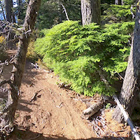
This trail has got it all. It's a great technical downhill and a challenging climb. There is some hike-a-bike involved on the steepest sections.
Creeks, waterfalls, and the incredible views from the cliffs make this trip extra rewarding. Its a extremely hard climb with 3000ft of vertical to conquer. The forest service road up is easier.

Trail Supporters
  • Sponsor

  • USFS
    Land Manager
Local Trail Association
Traditionally Indigenous Territory

Recent Activity on Trail

Past Week
  • 0 rides
  •  
6 Months
  • 0 rides
  •  
All
  • 143 rides
  • Last: May 24, 2026
c1c2c3c4
January
February
March
April
May
June
July
August
September
October
November
December
update trails status or condition

Palisades Trail Reports

statusdatedescription
Jun 2, 2026 @ 3:37pm (America/Los_Angeles)
Jun 2, 2026
There are many large trees down across the trail and the trail tread is very loose in places, I highly recommend not riding this trail at this time.
May 18, 2026 @ 9:51pm (America/Los_Angeles)
May 18, 2026
Multiple blowdowns. Cleared several smaller ones within the first 1/4 mile down from the intersection with Ranger but left 4x ~25" logs, at least...
Sep 6, 2025 @ 8:38am
Sep 6, 2025
Aug 30, 2025 @ 5:54pm
Aug 30, 2025
Blowdowns still present. Significant trail damage due to landside just below the steps/ladder section. About 100 yards of trail gone. Very...
Aug 22, 2025 @ 6:52pm
Aug 22, 2025
Great overall. Blowdown mentioned below still there. Landslide below the ladder took out a few switchbacks.
more »
Status:
on Jun 2, 2026
Dry
Avg: 4.29 (18 votes)
Your vote: 0

view (746)
close
3D
Trail Conditions
  • Unknown
  • Snow Groomed
  • Snow Packed
  • Snow Covered
  • Snow Cover Partial
  • Freeze/thaw Cycle
  • Icy
  • Prevalent Mud
  • Wet
  • Variable
  • Ideal
  • Dry
  • Very Dry
Trail Flow (Ridden Direction)
Trailforks scans users ridelogs to determine the most popular direction each trail is ridden. A good flowing trail network will have most trails flowing in a single direction according to their intension.
The colour categories are based on what percentage of riders are riding a trail in its intended direction.
  • > 96%
  • > 90%
  • > 80%
  • > 70%
  • > 50%
  • < 50%
  • bi-directional trail
  • no data
Trail Last Ridden
Trailforks scans ridelogs to determine the last time a trail was ridden.
  • < 2 days
  • < 1 week
  • < 2 weeks
  • < 1 month
  • < 6 months
  • > 6 months
Trail Ridden Direction
The intended direction a trail should be ridden.
  • Downhill Only
  • Downhill Primary
  • Both Directions
  • Uphill Primary
  • Uphill Only
  • One Direction
Contribute Details
Colors indicate trail is missing specified detail.
  • Description
  • Photos
  • Description & Photos
  • Videos
Trail Popularity ?
Trailforks scans ridelogs to determine which trails are ridden the most in the last 9 months. Trails are compared with nearby trails in the same city region with a possible 25 colour shades. Think of this as a heatmap, more rides = more kinetic energy = warmer colors.
  • most popular
  • popular
  • less popular
  • not popular
ATV/ORV/OHV Filter
Max Vehicle Width
inches
US Cell Coverage
Legend
cell carrier legend

Radar Time
Activity Recordings
Trailforks uses anonymized public activity data. ?
Activity Recordings
Trailforks uses anonymized public activity data. ?
Personal Heatmap
Activity Types
all / none
Options
2
Date range month
Winter Trails
Warning A routing network for winter maps does not exist. Selecting trails using the winter trails layer has been disabled.
Missing Trails
Most Popular
Least Popular
Trails are colored based on popularity. The more popular a trail is, the more red. Less popular trails trend towards green.
Jump Magnitude Heatmap
Heatmap of where riders jump on trails. Zoom in to see individual jumps, click circles to view jump details.
BC Backroad Status

Service Road Atlas is a free to use, community-driven service for viewing and creating reports on the numerous back-country service roads around B.C. and Alberta.

map legend
Slope Aspect
Direction the slope faces
Flat N NE E SE S SW W NW
Trails Deemphasized
Trails are shown in grey.
disable
Only show trails with no bike usage.
Enable
Suggested Layers
Based on selected activity type

    Save the current map location and zoom level as your default home location whenever this page is loaded.

    Save
        Directions to palisades trailhead (47.049030, -121.570160)

        Photos

        146 more »
        96 |
        Jul 13, 2024 @ 4:51pm
        Jul 13, 2024
        78 |
        Oct 14, 2023 @ 11:02pm
        Oct 14, 2023
        73 |
        Oct 14, 2023 @ 11:02pm
        Oct 14, 2023
        273 |
        Sep 6, 2022 @ 10:19pm
        Sep 6, 2022

        Videos

        4 more »
        youtuber VOTR Palisades Via Ranger Creek
        19:29 | 609 | Aug 12, 2021 , Greenwater
        VAN LIFE | Mt. Rainier to Tiger Mountain |...
        26:25 | 378 | Aug 23, 2020 , Greenwater
        Gimbal POV | Palisades MTB Trail | 410 Mt....
        23:49 | 1678 | Jul 23, 2020 , Greenwater
        Palisades Cliff Ride
        0:35 | 704 | Oct 22, 2018 , Greenwater

        Routes with this trail

        5.0 13 miles 2,851 ft 3 Loop
        This is a commonly ridden loop. Park near the White River Trail. Then ride the loop counterclockwise:...
        2.0 21 miles 4,618 ft 5 Loop
        Park at parking lot at Buck Creek turnoff, just across bridge from 410. Cross hwy 410 and go left 30...
        21 miles 4,618 ft 5 Loop
        Park at parking lot at Buck Creek turnoff, just across bridge from 410. Cross hwy 410 and go left 30...

        12 Reviews & Comments


        We hope you've been enjoying Trailforks!

        Create a FREE account to view trail comments and much more.

        • By enilson & contributors
        • #18855 - 15,522 views

        Frequently Asked Questions About Palisades

        Where is Palisades located?
        Palisades is located in 410 / Mount Rainier North, Greenwater, Washington, United States. It is part of the 410 / Mount Rainier North trail network. The trailhead is located at coordinates 47.04903, -121.57016.
        How hard is Palisades?
        Palisades is rated as Black Diamond difficulty. The physical rating is Hard. The average grade is 8.3%. The climb difficulty is rated Black Diamond.
        What is the elevation gain for Palisades?
        Palisades has 2,880 ft of elevation gain. The trail has 191 ft of elevation descent. The elevation ranges from 2,292 ft to 5,043 ft.
        Is Palisades a point to point trail?
        Palisades is not a point to point trail. The direction is Both Directions. The trail type is singletrack.

        Hit the Trail

        Open in App

        Get this trail on your phone instantly.
        open trail in app

        Download Trail

        Save to wishlist, Garmin & download.
        save the trail

        Find Related Routes

        Find routes and users activities that include this trail.
        find routes for this trail

        You must enter a description before submitting.