more stats
1,939 ft
Distance
-277 ft
Descent
00:02:21
Avg time
-277 ft
Altitude change
1,007 ft
Altitude min
1,284 ft
Altitude max
1,284 ft
Altitude start
1,007 ft
Altitude end
-14.3%
Grade
-50.4%
Grade max
1.5%
Grade min
10 ft
Distance climb
1,860 ft
Distance down
66 ft
Distance flat
00:02:21
Avg time

Pan Details

  • Activities
    • Mountain Bike
    • E-Bike
  • Riding Area
    Trailarea Göttweig
    Furth bei Göttweig
  • Ref Number
    B1
  • Difficulty Rating
  • Voted Difficulty
    Red (2 votes)
  • Local Popularity
    60 in Mountain Biking [+]
    • 50 in E-Biking
  • Global Ranking
    #82880 in Mountain Biking [+]
    • #80264 in E-Biking
  • Trail Type
    Singletrack
  • Bike Type
    DH, AM
  • Trail Visibility
    Always easy to follow
  • eBike Allowed
    Yes up to Class 1

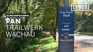
Pan, der Gott des Waldes. Dieser Trail war ein ungeplantes Kind, das wir aber umso mehr lieben. Bei der Festlegung der Wegführung mussten wir uns tagelang durchs Unterholz kämpfen, so ist der Name entstanden.
Table, Anlieger, Sprung, Anlieger, Querfahrt, Sprung, Felsen, Sprung, Steilabfahrt, Rockgarden ... und das war nur die erste Sektion. Wir wollten einen Trail bauen, der permanent fordert, aber nicht gefährlich ist. Ich hoffe das ist uns gelungen.

Recent Activity on Trail

Past Week
  • 0 rides
  •  
6 Months
  • 5 rides
  • 16 miles avg distance
All
  • 105 rides
  • Last: Jun 14, 2026
c1c2c3c4
January
February
March
April
May
June
July
August
September
October
November
December
update trails status or condition

Pan Trail Reports

statusdatedescription
Apr 18, 2026 @ 2:09pm (Europe/Vienna)
Apr 18, 2026
Mar 24, 2026 @ 9:20am (Europe/Vienna)
Mar 24, 2026
Feb 13, 2026 @ 7:15am (Europe/Vienna)
Feb 12, 2026
reporter
Jan 27, 2026 @ 2:51pm (Europe/Vienna)
Jan 27, 2026
reporter Trailarea Göttweig gesperrt. Wir müssen leider alle Trails der Trailarea Göttweig bis auf weiteres sperren. Das Glatteis auf den Trails wird...
Dec 13, 2025 @ 1:01pm (Europe/Vienna)
Dec 13, 2025
more »
Status:
on Apr 18, 2026
Dry
Avg: 4.41 (11 votes)
Your vote: 0

view (632)
close
3D
Trail Conditions
  • Unknown
  • Snow Groomed
  • Snow Packed
  • Snow Covered
  • Snow Cover Partial
  • Freeze/thaw Cycle
  • Icy
  • Prevalent Mud
  • Wet
  • Variable
  • Ideal
  • Dry
  • Very Dry
Trail Flow (Ridden Direction)
Trailforks scans users ridelogs to determine the most popular direction each trail is ridden. A good flowing trail network will have most trails flowing in a single direction according to their intension.
The colour categories are based on what percentage of riders are riding a trail in its intended direction.
  • > 96%
  • > 90%
  • > 80%
  • > 70%
  • > 50%
  • < 50%
  • bi-directional trail
  • no data
Trail Last Ridden
Trailforks scans ridelogs to determine the last time a trail was ridden.
  • < 2 days
  • < 1 week
  • < 2 weeks
  • < 1 month
  • < 6 months
  • > 6 months
Trail Ridden Direction
The intended direction a trail should be ridden.
  • Downhill Only
  • Downhill Primary
  • Both Directions
  • Uphill Primary
  • Uphill Only
  • One Direction
Contribute Details
Colors indicate trail is missing specified detail.
  • Description
  • Photos
  • Description & Photos
  • Videos
Trail Popularity ?
Trailforks scans ridelogs to determine which trails are ridden the most in the last 9 months. Trails are compared with nearby trails in the same city region with a possible 25 colour shades. Think of this as a heatmap, more rides = more kinetic energy = warmer colors.
  • most popular
  • popular
  • less popular
  • not popular
ATV/ORV/OHV Filter
Max Vehicle Width
inches
US Cell Coverage
Legend
cell carrier legend

Radar Time
Activity Recordings
Trailforks uses anonymized public activity data. ?
Activity Recordings
Trailforks uses anonymized public activity data. ?
Personal Heatmap
Activity Types
all / none
Options
2
Date range month
Winter Trails
Warning A routing network for winter maps does not exist. Selecting trails using the winter trails layer has been disabled.
Missing Trails
Most Popular
Least Popular
Trails are colored based on popularity. The more popular a trail is, the more red. Less popular trails trend towards green.
Jump Magnitude Heatmap
Heatmap of where riders jump on trails. Zoom in to see individual jumps, click circles to view jump details.
BC Backroad Status

Service Road Atlas is a free to use, community-driven service for viewing and creating reports on the numerous back-country service roads around B.C. and Alberta.

map legend
Slope Aspect
Direction the slope faces
Flat N NE E SE S SW W NW
Trails Deemphasized
Trails are shown in grey.
disable
Only show trails with no bike usage.
Enable
Suggested Layers
Based on selected activity type

    Save the current map location and zoom level as your default home location whenever this page is loaded.

    Save
        Directions to pan trailhead (48.364430, 15.615220)

        Photos

        3 more »
        85 |
        Aug 12, 2024 @ 2:14am
        Aug 12, 2024
        98 |
        Aug 12, 2024 @ 2:08am
        Aug 12, 2024
        759 |
        Oct 19, 2019 @ 5:30am
        Oct 19, 2019

        Videos

        4 more »
        youtuber Pan Mountain Bike Trail ☀️ 2021 |...
        2:08 | 647 | Jul 8, 2021 , Furth bei Göttweig
        Pan - Trailarea Göttweig by Trailwerk Wachau
        2:08 | 86 | Mar 19, 2025 , Furth bei Göttweig
        PAN Trial (Red)  / Stift Göttweig / Trailwerk...
        2:13 | 331 | Jun 3, 2021 , Furth bei Göttweig
        Pan - Trailwerk Wachau | LINES
        2:05 | 539 | Sep 21, 2019 , Furth bei Göttweig

        Reviews / Comments

        No reviews yet, be the first to write a review or ask a question.
        Use trail reports to comment on trail conditions.


        We hope you've been enjoying Trailforks!

        Create a FREE account to view trail comments and much more.

        • By TrailwerkWachauTF Pro TRAILWERK & contributors
        • #207697 - 4,572 views

        Frequently Asked Questions About Pan

        Where is Pan located?
        Pan is located in Trailarea Göttweig, Furth bei Göttweig, Austria. It is part of the Trailarea Göttweig trail network. The trailhead is located at coordinates 48.36443, 15.61522.
        How hard is Pan?
        Pan is rated as Red difficulty. The average grade is 14.3%.
        What is the elevation gain for Pan?
        The trail has 85 m of elevation descent. The elevation ranges from 307 m to 391 m.
        How long is Pan?
        Pan is 591.0 m long. The trail type is singletrack.

        Hit the Trail

        Open in App

        Get this trail on your phone instantly.
        open trail in app

        Download Trail

        Save to wishlist, Garmin & download.
        save the trail

        Find Related Routes

        Find routes and users activities that include this trail.
        find routes for this trail

        You must enter a description before submitting.