more stats
2.5 miles
Distance
223 ft
Climb
-1,530 ft
Descent
00:15:38
Avg time
-1,307 ft
Altitude change
4,538 ft
Altitude min
5,850 ft
Altitude max
5,850 ft
Altitude start
4,544 ft
Altitude end
-10%
Grade
-59.9%
Grade max
23.6%
Grade min
2,717 ft
Distance climb
2 miles
Distance down
1,670 ft
Distance flat
00:15:38
Avg time

Panorama Trail Details

  • Activities
    • Mountain Bike
    • E-Bike
  • Riding Area
    Bike-Circus - Saalbach Hinterglemm
    Saalbach Hinterglemm
  • Ref Number
    SH01
  • Difficulty Rating
  • Voted Difficulty
    Green (6 votes)
  • Local Popularity
    100 in Mountain Biking [+]
    • 100 in E-Biking
  • Global Ranking
    #788 in Mountain Biking [+]
    • #911 in E-Biking
  • Trail Type
    Singletrack
  • Direction
    Downhill Only
    Popular Direction Shown
  • Trail Visibility
    Always easy to follow
  • Family Friendly
    Yes
  • Dogs Allowed
    Yes
  • eBike Allowed
    Yes up to Class 1
  • TTFs on Trail
    Jump, Pump Track
  • Land Owner

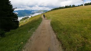
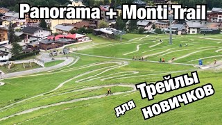
The start of the Panorama Trail is right at the top station of the Kohlmais lift. Use the exit on the left side. Located right next to the station you can find easily the start of the Panorama Trail. Super flowy for experienced bikers and easy to ride for newcomers, the trail passes after the first few meters a forest road - low speed and consideration to hikers and children Then the trail leads over open fields, followed by a brief excursion into the forest and continues over easy tables, waves and steep bends direct to the Panorama Alm. Here you have the choice: To your left at the first sharp turn you will find the Egger Trail (part of the BIG-5 route) or if you continue the dirt road you will end up at the mid station (start Milka Line). And if you take the right side the forest road leads you towards a by-pass in the direction of the Milka Line or follow the street to the Spielberghaus, where the technically “Höllen Trail” waits for you.

Bike Park

Recent Activity on Trail

Past Week
  • 17 rides
  • 44.6 km average
6 Months
  • 51 rides
  • 37.7 km avg distance
All
  • 829 rides
  • Last: Jun 19, 2026
c1c2c3c4
January
February
March
April
May
June
July
August
September
October
November
December
update trails status or condition

Panorama Trail Trail Reports

statusdatedescription
Jun 12, 2026 @ 8:47am (Europe/Vienna)
Jun 11, 2026
oben minimal schnee, danach alles feucht. stellenweise frisch planiert und überarbeitet, einzelne kurze abschnitte mit übelst bremswellen und...
Sep 11, 2025 @ 9:59am
Sep 11, 2025
Sep 10, 2025 @ 8:49am
Sep 10, 2025
Aug 16, 2025 @ 10:13am
Aug 16, 2025
Jul 26, 2025 @ 5:44am
Jul 26, 2025
more »
Status:
on Jun 12, 2026
Wet
Avg: 3.87 (47 votes)
Your vote: 0

view (9,287)
close
3D
Trail Conditions
  • Unknown
  • Snow Groomed
  • Snow Packed
  • Snow Covered
  • Snow Cover Partial
  • Freeze/thaw Cycle
  • Icy
  • Prevalent Mud
  • Wet
  • Variable
  • Ideal
  • Dry
  • Very Dry
Trail Flow (Ridden Direction)
Trailforks scans users ridelogs to determine the most popular direction each trail is ridden. A good flowing trail network will have most trails flowing in a single direction according to their intension.
The colour categories are based on what percentage of riders are riding a trail in its intended direction.
  • > 96%
  • > 90%
  • > 80%
  • > 70%
  • > 50%
  • < 50%
  • bi-directional trail
  • no data
Trail Last Ridden
Trailforks scans ridelogs to determine the last time a trail was ridden.
  • < 2 days
  • < 1 week
  • < 2 weeks
  • < 1 month
  • < 6 months
  • > 6 months
Trail Ridden Direction
The intended direction a trail should be ridden.
  • Downhill Only
  • Downhill Primary
  • Both Directions
  • Uphill Primary
  • Uphill Only
  • One Direction
Contribute Details
Colors indicate trail is missing specified detail.
  • Description
  • Photos
  • Description & Photos
  • Videos
Trail Popularity ?
Trailforks scans ridelogs to determine which trails are ridden the most in the last 9 months. Trails are compared with nearby trails in the same city region with a possible 25 colour shades. Think of this as a heatmap, more rides = more kinetic energy = warmer colors.
  • most popular
  • popular
  • less popular
  • not popular
ATV/ORV/OHV Filter
Max Vehicle Width
inches
US Cell Coverage
Legend
cell carrier legend

Radar Time
Activity Recordings
Trailforks uses anonymized public activity data. ?
Activity Recordings
Trailforks uses anonymized public activity data. ?
Personal Heatmap
Activity Types
all / none
Options
2
Date range month
Winter Trails
Warning A routing network for winter maps does not exist. Selecting trails using the winter trails layer has been disabled.
Missing Trails
Most Popular
Least Popular
Trails are colored based on popularity. The more popular a trail is, the more red. Less popular trails trend towards green.
Jump Magnitude Heatmap
Heatmap of where riders jump on trails. Zoom in to see individual jumps, click circles to view jump details.
BC Backroad Status

Service Road Atlas is a free to use, community-driven service for viewing and creating reports on the numerous back-country service roads around B.C. and Alberta.

map legend
Slope Aspect
Direction the slope faces
Flat N NE E SE S SW W NW
Trails Deemphasized
Trails are shown in grey.
disable
Only show trails with no bike usage.
Enable
Suggested Layers
Based on selected activity type

    Save the current map location and zoom level as your default home location whenever this page is loaded.

    Save
        Directions to panorama-trail trailhead (47.410090, 12.653470)

        Photos

        20 more »
        1,396 |
        Jan 20, 2020 @ 5:06am
        Jan 20, 2020
        1,777 |
        Jan 20, 2020 @ 5:06am
        Jan 20, 2020
        57 |
        Sep 15, 2024 @ 9:08am
        Sep 15, 2024
        132 |
        Aug 10, 2022 @ 3:42am
        Aug 10, 2022

        Videos

        23 more »
        youtuber SAALBACH HINTERGLEMM Blue Lines: Panorama,...
        8:40 | 291 | Sep 29, 2023 , Saalbach Hinterglemm
        youtuber Panorama Trail | SH01- Bike Circus Saalbach...
        8:23 | 11 | May 26, 2026 , Saalbach Hinterglemm
        SAALBACH-HINTERGLEMM! Panorama Trail
        19:55 | 57 | May 6, 2025 , Saalbach Hinterglemm
        Saalbach Bikepark - Blue Trail \ Panorama-Line...
        8:15 | 51 | Dec 5, 2024 , Saalbach Hinterglemm

        Routes with this trail

        4.5 38 miles 12,614 ft 14 Loop
        Die BIG-5 Bike Challenge vereint sechs Seilbahnen und fünf Berge rund um Saalbach Hinterglemm und Leogang...
        2.0 57 miles 16,295 ft 12 Loop
        Dank moderner Bergbahnen ist das an einem Tag zu schaffen! Stellt euch dabei auf pure Trailfreuden in...

        2 Reviews & Comments


        We hope you've been enjoying Trailforks!

        Create a FREE account to view trail comments and much more.

        Frequently Asked Questions About Panorama Trail

        Where is Panorama Trail located?
        Panorama Trail is located in Bike-Circus - Saalbach Hinterglemm, Saalbach Hinterglemm, Austria. It is part of the Bike-Circus - Saalbach Hinterglemm trail network. The trailhead is located at coordinates 47.41009, 12.65347.
        How hard is Panorama Trail?
        Panorama Trail is rated as Blue difficulty. The average grade is 10%.
        What is the elevation gain for Panorama Trail?
        Panorama Trail has 68 m of elevation gain. The trail has 466 m of elevation descent. The elevation ranges from 1,383 m to 1,783 m.
        Is Panorama Trail a point to point trail?
        Yes, Panorama Trail is a point to point trail. The direction is Downhill Only. The trail type is singletrack.

        Hit the Trail

        Open in App

        Get this trail on your phone instantly.
        open trail in app

        Download Trail

        Save to wishlist, Garmin & download.
        save the trail

        Find Related Routes

        Find routes and users activities that include this trail.
        find routes for this trail

        You must enter a description before submitting.