more stats
4,160 ft
Distance
-626 ft
Descent
3,622 ft
High Point
-626 ft
Altitude change
2,996 ft
Altitude min
3,622 ft
Altitude start
2,995 ft
Altitude end
-15%
Grade
-37.8%
Grade max
1%
Grade min
62 ft
Distance climb
3,934 ft
Distance down
161 ft
Distance flat

Paper Cut Details

  • Activities
    • Mountain Bike
    • E-Bike
  • Riding Area
    Grouse Mountain Bike Park
    North Vancouver, British Columbia
  • Difficulty Rating
  • Voted Difficulty
    Black Diamond (1 vote)
  • Local Popularity
    80 in Mountain Biking [+]
    • 65 in E-Biking
  • Global Ranking
    #13916 in Mountain Biking [+]
    • #50260 in E-Biking
  • Trail Type
    Singletrack
  • Bike Type
    DH, AM
  • Physical Rating
    Moderate
  • Trail Visibility
    Always easy to follow
  • eBike Allowed
  • TTFs on Trail
    Berm, Drop, Jump, Rock Face, Rock Garden
  • Land Owner

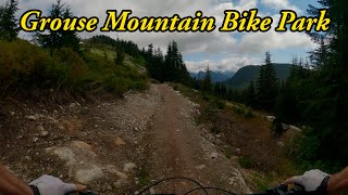
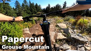
Paper Cut is an ode to the 2001, 2002, and 2003 World Cups held on Grouse Mountain. The World Cup downhill trail was designed by local rider Andrew Shandro, and Paper Cut follows most of the 1.2 km long World Cup DH route. This trail features all the elements you'd expect on a black technical trail—rock drops, steep chutes, rock gardens, fast and flowy sections, tight turns, and more. Paper Cut is sure to keep advanced and expert riders entertained from top to bottom.

Bike Park

Recent Activity on Trail

Past Week
  • 56 rides
  • 22.7 km average
6 Months
  • 101 rides
  • 21.3 km avg distance
All
  • 540 rides
  • Last: Jun 21, 2026
c1c2c3c4
January
February
March
April
May
June
July
August
September
October
November
December
Status:
on Jun 16, 2026
Dry
Avg: 4.31 (10 votes)
Your vote: 0

view (3,919)
close
3D
Trail Conditions
  • Unknown
  • Snow Groomed
  • Snow Packed
  • Snow Covered
  • Snow Cover Partial
  • Freeze/thaw Cycle
  • Icy
  • Prevalent Mud
  • Wet
  • Variable
  • Ideal
  • Dry
  • Very Dry
Trail Flow (Ridden Direction)
Trailforks scans users ridelogs to determine the most popular direction each trail is ridden. A good flowing trail network will have most trails flowing in a single direction according to their intension.
The colour categories are based on what percentage of riders are riding a trail in its intended direction.
  • > 96%
  • > 90%
  • > 80%
  • > 70%
  • > 50%
  • < 50%
  • bi-directional trail
  • no data
Trail Last Ridden
Trailforks scans ridelogs to determine the last time a trail was ridden.
  • < 2 days
  • < 1 week
  • < 2 weeks
  • < 1 month
  • < 6 months
  • > 6 months
Trail Ridden Direction
The intended direction a trail should be ridden.
  • Downhill Only
  • Downhill Primary
  • Both Directions
  • Uphill Primary
  • Uphill Only
  • One Direction
Contribute Details
Colors indicate trail is missing specified detail.
  • Description
  • Photos
  • Description & Photos
  • Videos
Trail Popularity ?
Trailforks scans ridelogs to determine which trails are ridden the most in the last 9 months. Trails are compared with nearby trails in the same city region with a possible 25 colour shades. Think of this as a heatmap, more rides = more kinetic energy = warmer colors.
  • most popular
  • popular
  • less popular
  • not popular
ATV/ORV/OHV Filter
Max Vehicle Width
inches
US Cell Coverage
Legend
cell carrier legend

Radar Time
Activity Recordings
Trailforks uses anonymized public activity data. ?
Activity Recordings
Trailforks uses anonymized public activity data. ?
Personal Heatmap
Activity Types
all / none
Options
2
Date range month
Winter Trails
Warning A routing network for winter maps does not exist. Selecting trails using the winter trails layer has been disabled.
Missing Trails
Most Popular
Least Popular
Trails are colored based on popularity. The more popular a trail is, the more red. Less popular trails trend towards green.
Jump Magnitude Heatmap
Heatmap of where riders jump on trails. Zoom in to see individual jumps, click circles to view jump details.
BC Backroad Status

Service Road Atlas is a free to use, community-driven service for viewing and creating reports on the numerous back-country service roads around B.C. and Alberta.

map legend
Slope Aspect
Direction the slope faces
Flat N NE E SE S SW W NW
Trails Deemphasized
Trails are shown in grey.
disable
Only show trails with no bike usage.
Enable
Suggested Layers
Based on selected activity type

    Save the current map location and zoom level as your default home location whenever this page is loaded.

    Save
        Directions to paper-cut trailhead (49.380350, -123.080350)

        Photos

        4 more »
        2 |
        Jun 19, 2026 @ 6:27pm
        2 days
        2 |
        Jun 19, 2026 @ 6:27pm
        2 days
        1 |
        Jun 19, 2026 @ 6:19pm
        2 days
        76 |
        Feb 26, 2026 @ 5:03pm
        Feb 26, 2026

        Videos

        4 more »
        youtuber Grouse Mountain Bike Park - Opening Day!
        15:41 | 252 | Jun 28, 2025 , North Vancouver
        Papercut - Grouse Mountain 2025
        3:36 | 91 | Oct 17, 2025 , North Vancouver
        youtuber Riding the North Shores New Bike Park | Grouse...
        6:47 | 142 | Jun 29, 2025 , North Vancouver
        Papercut Grouse Mountain Bike Park
        188 | Jun 12, 2025 , North Vancouver

        3 Reviews & Comments


        We hope you've been enjoying Trailforks!

        Create a FREE account to view trail comments and much more.

        • By kyleluvsdhTF Pro & contributors
        • #832930 - 1,116 views

        Frequently Asked Questions About Paper Cut

        Where is Paper Cut located?
        Paper Cut is located in Grouse Mountain Bike Park, North Vancouver, British Columbia, Canada. It is part of the Grouse Mountain Bike Park trail network. The trailhead is located at coordinates 49.38035, -123.08035.
        How hard is Paper Cut?
        Paper Cut is rated as Black Diamond difficulty. The physical rating is Moderate. The average grade is 15%.
        What is the elevation gain for Paper Cut?
        The trail has 626 ft of elevation descent. The elevation ranges from 2,996 ft to 3,622 ft.
        How long is Paper Cut?
        Paper Cut is 4,160 ft long. The trail type is singletrack.

        Hit the Trail

        Open in App

        Get this trail on your phone instantly.
        open trail in app

        Download Trail

        Save to wishlist, Garmin & download.
        save the trail

        Find Related Routes

        Find routes and users activities that include this trail.
        find routes for this trail

        You must enter a description before submitting.