more stats
4,406 ft
Distance
110 ft
Climb
-135 ft
Descent
00:13:10
Avg time
-24 ft
Altitude change
802 ft
Altitude min
915 ft
Altitude max
826 ft
Altitude start
801 ft
Altitude end
-0.6%
Grade
-19.8%
Grade max
39.2%
Grade min
1,339 ft
Distance climb
2,146 ft
Distance down
922 ft
Distance flat
00:13:10
Avg time

Parsifal Details

  • Activities
    • Mountain Bike
    • E-Bike
    • Winter Fat Bike
    • Hike
    • Trail Running
  • Riding Area
    Finale Outdoor Region
    Finale Ligure
  • Ref Number
    #217
  • Difficulty Rating
  • Local Popularity
    40 in Mountain Biking [+]
    • 50 in E-Biking
    • 100 in Trail Running
    • 95 in Hiking
  • Global Ranking
    #115586 in Mountain Biking [+]
    • #69835 in E-Biking
    • #1697 in Trail Running
    • #2640 in Hiking
  • Hiking SAC Scale
    T1 Hiking
  • Trail Type
    Singletrack
  • Bike Type
    AM, XC, Fat
  • Direction
    Both Directions
  • Climb Difficulty
    Blue
  • Physical Rating
    Moderate
  • Trail Visibility
    Always easy to follow
  • Season
    All-year round
  • Dogs Allowed
    Yes
  • eBike Allowed
    Yes up to Class 1
  • Land Owner
    Finale Outdoor Region

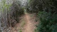
Connection trail rideable in both ways that links Bondi Trail to the Strada della Cappelletta in its highest part.
It is a great uphill connection to stay up high: flow and rich of switchbacks.

source: ...
Access Info

Caprazoppa is reachable from the E80 highway accessing Finale Ligure, then drive north on the SP490 until Gorra. At that point take a sharp left on Via per Gorra towards Verezzi.

Disclaimer

Given its nature, the trail can change after weather happenings and season changes. Always pay attention.

Trail Supporters
Local Trail Association

Recent Activity on Trail

Past Week
  • 0 rides
  •  
6 Months
  • 21 rides
  • 15 miles avg distance
All
  • 98 rides
  • Last: Jun 7, 2026
c1c2c3c4
January
February
March
April
May
June
July
August
September
October
November
December
Status:
on Apr 26, 2026
Dry
Avg: 3.9 (5 votes)
Your vote: 0

view (910)
close
3D
Trail Conditions
  • Unknown
  • Snow Groomed
  • Snow Packed
  • Snow Covered
  • Snow Cover Partial
  • Freeze/thaw Cycle
  • Icy
  • Prevalent Mud
  • Wet
  • Variable
  • Ideal
  • Dry
  • Very Dry
Trail Flow (Ridden Direction)
Trailforks scans users ridelogs to determine the most popular direction each trail is ridden. A good flowing trail network will have most trails flowing in a single direction according to their intension.
The colour categories are based on what percentage of riders are riding a trail in its intended direction.
  • > 96%
  • > 90%
  • > 80%
  • > 70%
  • > 50%
  • < 50%
  • bi-directional trail
  • no data
Trail Last Ridden
Trailforks scans ridelogs to determine the last time a trail was ridden.
  • < 2 days
  • < 1 week
  • < 2 weeks
  • < 1 month
  • < 6 months
  • > 6 months
Trail Ridden Direction
The intended direction a trail should be ridden.
  • Downhill Only
  • Downhill Primary
  • Both Directions
  • Uphill Primary
  • Uphill Only
  • One Direction
Contribute Details
Colors indicate trail is missing specified detail.
  • Description
  • Photos
  • Description & Photos
  • Videos
Trail Popularity ?
Trailforks scans ridelogs to determine which trails are ridden the most in the last 9 months. Trails are compared with nearby trails in the same city region with a possible 25 colour shades. Think of this as a heatmap, more rides = more kinetic energy = warmer colors.
  • most popular
  • popular
  • less popular
  • not popular
ATV/ORV/OHV Filter
Max Vehicle Width
inches
US Cell Coverage
Legend
cell carrier legend

Radar Time
Activity Recordings
Trailforks uses anonymized public activity data. ?
Activity Recordings
Trailforks uses anonymized public activity data. ?
Personal Heatmap
Activity Types
all / none
Options
2
Date range month
Winter Trails
Warning A routing network for winter maps does not exist. Selecting trails using the winter trails layer has been disabled.
Missing Trails
Most Popular
Least Popular
Trails are colored based on popularity. The more popular a trail is, the more red. Less popular trails trend towards green.
Jump Magnitude Heatmap
Heatmap of where riders jump on trails. Zoom in to see individual jumps, click circles to view jump details.
BC Backroad Status

Service Road Atlas is a free to use, community-driven service for viewing and creating reports on the numerous back-country service roads around B.C. and Alberta.

map legend
Slope Aspect
Direction the slope faces
Flat N NE E SE S SW W NW
Trails Deemphasized
Trails are shown in grey.
disable
Only show trails with no bike usage.
Enable
Suggested Layers
Based on selected activity type

    Save the current map location and zoom level as your default home location whenever this page is loaded.

    Save
        Directions to parsifal trailhead (44.167170, 8.330710)

        Photos

        14 more »
        81 |
        Jul 1, 2023 @ 12:46pm
        Jul 1, 2023
        71 |
        Jul 1, 2023 @ 12:46pm
        Jul 1, 2023
        76 |
        Jul 1, 2023 @ 12:46pm
        Jul 1, 2023
        75 |
        Jul 1, 2023 @ 12:46pm
        Jul 1, 2023

        Videos

        1 more »
        0:54 | 84 | Jan 19, 2025 , Finale Ligure

        Reviews / Comments

        No reviews yet, be the first to write a review or ask a question.
        Use trail reports to comment on trail conditions.


        We hope you've been enjoying Trailforks!

        Create a FREE account to view trail comments and much more.

        Frequently Asked Questions About Parsifal

        Where is Parsifal located?
        Parsifal is located in Finale Outdoor Region, Finale Ligure, Italy. It is part of the Finale Outdoor Region trail network. The trailhead is located at coordinates 44.16717, 8.33071.
        How hard is Parsifal?
        Parsifal is rated as Blue difficulty. The physical rating is Moderate. The average grade is 0.6%. The climb difficulty is rated Blue.
        What is the elevation gain for Parsifal?
        Parsifal has 110 ft of elevation gain. The trail has 135 ft of elevation descent. The elevation ranges from 802 ft to 915 ft.
        Is Parsifal a point to point trail?
        Parsifal is not a point to point trail. The direction is Both Directions. The trail type is singletrack.

        Hit the Trail

        Open in App

        Get this trail on your phone instantly.
        open trail in app

        Download Trail

        Save to wishlist, Garmin & download.
        save the trail

        Find Related Routes

        Find routes and users activities that include this trail.
        find routes for this trail

        You must enter a description before submitting.