more stats
2.9 miles
Distance
191 ft
Climb
-2,927 ft
Descent
01:19:33
Avg time
-2,736 ft
Altitude change
7,097 ft
Altitude min
9,836 ft
Altitude max
9,836 ft
Altitude start
7,100 ft
Altitude end
-18%
Grade
-107%
Grade max
46.7%
Grade min
1,798 ft
Distance climb
2 miles
Distance down
669 ft
Distance flat
01:19:33
Avg time

Passo Zebru' Details

  • Activities
    • Mountain Bike
    • E-Bike
    • Hike
    • Trail Running
  • Riding Area
    Stelvio Natural Trail Park
    Santa Caterina Valfurva
  • Difficulty Rating
  • Local Popularity
    80 in Mountain Biking [+]
    • 70 in E-Biking
    • 90 in Trail Running
    • 75 in Hiking
  • Global Ranking
    #87640 in Mountain Biking [+]
    • #59978 in E-Biking
    • #131008 in Trail Running
    • #70022 in Hiking
  • Hiking SAC Scale
    T2 Mountain Hiking
  • Trail Type
    Singletrack
  • Bike Type
    AM
  • Direction
    Downhill Primary
    Popular Direction Shown
  • Alpine Trail
    Yes
  • Dogs Allowed
    Yes
  • eBike Allowed
    Yes up to Class 1
  • TTFs on Trail
    Skinny
  • Land Owner
    Stelvio Natural Trail Park

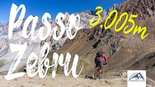
Dal passo Zebru (3000m) la discesa è spettacolare, a tratti tecnica S3/S4 ma in gran parte scorrevole S2,

Dal bivio del rifugio Quinto alpini diventa più banale; verso il finale la discesa torna interessante S3.

Trail Supporters
  • Sponsor

Recent Activity on Trail

Past Week
  • 0 rides
  •  
6 Months
  • 1 rides
  • 225.0 km avg distance
All
  • 20 rides
  • Last: Apr 7, 2026
c1c2c3c4
January
February
March
April
May
June
July
August
September
October
November
December
update trails status or condition

Passo Zebru' Trail Reports

statusdatedescription
Jul 30, 2024 @ 1:51pm
Jul 30, 2024
Some snow
Feb 21, 2024 @ 1:15pm
Feb 21, 2024
Sentiero Franato
Aug 2, 2023 @ 4:38am
Aug 2, 2023
Due frane difficoltose da superare…
Jul 29, 2023 @ 12:37am
Jul 29, 2023
Good conditions, Be careful with rock falls at the beginning!
Aug 11, 2022 @ 11:40pm
Aug 11, 2022
there are two parts where the trail has collapsed but is easily passed with the bike in hand.
more »
Status:
on Jul 30, 2024
Ideal
Avg: 4.14 (9 votes)
Your vote: 0

view (103)
close
3D
Trail Conditions
  • Unknown
  • Snow Groomed
  • Snow Packed
  • Snow Covered
  • Snow Cover Partial
  • Freeze/thaw Cycle
  • Icy
  • Prevalent Mud
  • Wet
  • Variable
  • Ideal
  • Dry
  • Very Dry
Trail Flow (Ridden Direction)
Trailforks scans users ridelogs to determine the most popular direction each trail is ridden. A good flowing trail network will have most trails flowing in a single direction according to their intension.
The colour categories are based on what percentage of riders are riding a trail in its intended direction.
  • > 96%
  • > 90%
  • > 80%
  • > 70%
  • > 50%
  • < 50%
  • bi-directional trail
  • no data
Trail Last Ridden
Trailforks scans ridelogs to determine the last time a trail was ridden.
  • < 2 days
  • < 1 week
  • < 2 weeks
  • < 1 month
  • < 6 months
  • > 6 months
Trail Ridden Direction
The intended direction a trail should be ridden.
  • Downhill Only
  • Downhill Primary
  • Both Directions
  • Uphill Primary
  • Uphill Only
  • One Direction
Contribute Details
Colors indicate trail is missing specified detail.
  • Description
  • Photos
  • Description & Photos
  • Videos
Trail Popularity ?
Trailforks scans ridelogs to determine which trails are ridden the most in the last 9 months. Trails are compared with nearby trails in the same city region with a possible 25 colour shades. Think of this as a heatmap, more rides = more kinetic energy = warmer colors.
  • most popular
  • popular
  • less popular
  • not popular
ATV/ORV/OHV Filter
Max Vehicle Width
inches
US Cell Coverage
Legend
cell carrier legend

Radar Time
Activity Recordings
Trailforks uses anonymized public activity data. ?
Activity Recordings
Trailforks uses anonymized public activity data. ?
Personal Heatmap
Activity Types
all / none
Options
2
Date range month
Winter Trails
Warning A routing network for winter maps does not exist. Selecting trails using the winter trails layer has been disabled.
Missing Trails
Most Popular
Least Popular
Trails are colored based on popularity. The more popular a trail is, the more red. Less popular trails trend towards green.
Jump Magnitude Heatmap
Heatmap of where riders jump on trails. Zoom in to see individual jumps, click circles to view jump details.
BC Backroad Status

Service Road Atlas is a free to use, community-driven service for viewing and creating reports on the numerous back-country service roads around B.C. and Alberta.

map legend
Slope Aspect
Direction the slope faces
Flat N NE E SE S SW W NW
Trails Deemphasized
Trails are shown in grey.
disable
Only show trails with no bike usage.
Enable
Suggested Layers
Based on selected activity type

    Save the current map location and zoom level as your default home location whenever this page is loaded.

    Save
        Directions to passo-zebru trailhead (46.456980, 10.561140)

        Photos

        43 more »
        65 |
        Feb 21, 2024 @ 1:15pm
        Feb 21, 2024
        72 |
        Feb 21, 2024 @ 1:15pm
        Feb 21, 2024
        69 |
        Feb 21, 2024 @ 1:15pm
        Feb 21, 2024
        71 |
        Feb 21, 2024 @ 1:15pm
        Feb 21, 2024

        Videos

        2 more »
        Passo Zebrù mit dem MTB - packender Panorama...
        5:04 | 391 | Aug 5, 2022 , Santa Caterina Valfurva
        The Summer Blizzard
        4:59 | 1756 | May 3, 2019 , Santa Caterina Valfurva

        Routes with this trail

        4.0 19 miles 6,328 ft 2 Loop
        With this ride you will discover the true meaning of ‘Alpine cycling’. The Oblio di Zebruisus is...
        54 miles 17,027 ft 4
        giro del ghiacciaio dell'Ortles

        3 Reviews & Comments


        We hope you've been enjoying Trailforks!

        Create a FREE account to view trail comments and much more.

        • By StelvioNaturalTrailPark & contributors
        • #84032 - 3,276 views

        Frequently Asked Questions About Passo Zebru'

        Where is Passo Zebru' located?
        Passo Zebru' is located in Stelvio Natural Trail Park, Santa Caterina Valfurva, Italy. It is part of the Stelvio Natural Trail Park trail network. The trailhead is located at coordinates 46.45698, 10.56114.
        How hard is Passo Zebru'?
        Passo Zebru' is rated as Red difficulty. The average grade is 18%.
        What is the elevation gain for Passo Zebru'?
        Passo Zebru' has 58 m of elevation gain. The trail has 892 m of elevation descent. The elevation ranges from 2,163 m to 2,998 m.
        Is Passo Zebru' a point to point trail?
        Passo Zebru' is not a point to point trail. The direction is Downhill Primary. The trail type is singletrack.

        Hit the Trail

        Open in App

        Get this trail on your phone instantly.
        open trail in app

        Download Trail

        Save to wishlist, Garmin & download.
        save the trail

        Find Related Routes

        Find routes and users activities that include this trail.
        find routes for this trail

        You must enter a description before submitting.