more stats
4,396 ft
Distance
-461 ft
Descent
00:10:16
Avg time
-463 ft
Altitude change
4,043 ft
Altitude min
4,506 ft
Altitude max
4,506 ft
Altitude start
4,042 ft
Altitude end
-10.5%
Grade
-30.8%
Grade max
1.4%
Grade min
98 ft
Distance climb
4,209 ft
Distance down
59 ft
Distance flat
00:10:16
Avg time

Paydirt Details

  • Activities
    • Mountain Bike
    • E-Bike
  • Riding Area
    Red Mountain Resort Bike Park
    Rossland, British Columbia
  • Difficulty Rating
  • Voted Difficulty
    Blue (1 vote)
  • Local Popularity
    90 in Mountain Biking [+]
    • 55 in E-Biking
  • Global Ranking
    #39763 in Mountain Biking [+]
    • #90113 in E-Biking
  • Trail Type
    Mixed
  • Bike Type
    DH, AM, XC
  • Direction
    Downhill Only[+]
    Popular Direction Shown
    • Downhill Only for E-Biking
  • Physical Rating
    Moderate
  • Trail Visibility
    Always easy to follow
  • Season
    June- Sept
  • eBike Allowed
    Yes up to Class 1
  • TTFs on Trail
    Berm, Bridge, Jump, Ladder Bridge, Pump Track, Rock Face, Wallride
  • Land Owner

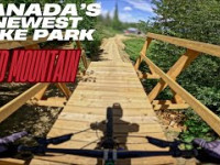
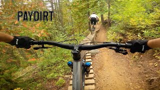
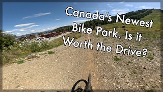
Pay Dirt is a classic reborn—a fast, flow-driven descent that blends legacy lines from the early days of the bike park with modern trail design. Originally roughed in nearly two decades ago during the first wave of freeride-era development, Pay Dirt has evolved from a raw, gravity-fed line into a polished and playful singletrack, thanks to thoughtful updates and consistent care.

The Kootenay Columbia Trails Society (KCTS) has played a key role in keeping this trail alive and thriving, maintaining its original character while improving drainage, smoothing transitions, and reinforcing key sections to handle today’s higher trail traffic. Riders will find a mix of old-school roots and rough-in sections alongside machine-shaped berms, rollers, and optional airs that keep things fun and dynamic.

This intermediate-to-advanced trail rewards momentum, flow, and precision. Whether you're reliving the early freeride spirit or discovering it for the first time, Pay Dirt delivers that golden ratio of speed, rhythm, and challenge.

A must-ride for anyone who appreciates trails with deep roots and fresh flow.

Access Info

Grab a bike park pass and head to the top of Silverload Chair. The trail starts just to the north of the chair.

Bike Park

Recent Activity on Trail

Past Week
  • 16 rides
  • 16 miles average
6 Months
  • 17 rides
  • 16 miles avg distance
All
  • 557 rides
  • Last: Jun 22, 2026
c1c2c3c4
January
February
March
April
May
June
July
August
September
October
November
December
update trails status or condition

Paydirt Trail Reports

statusdatedescription
Jun 20, 2026 @ 9:56am (America/Creston)
3 days
Trail clear and running well.
May 26, 2026 @ 1:57pm (America/Vancouver)
May 26, 2026
reporter While we work on getting the Bike Park ready we appreciate your respecting the trails are closed for access. We have machinery and vehicles...
Jun 21, 2025 @ 6:54am
Jun 21, 2025
reporter
Jun 20, 2025 @ 7:32pm
Jun 20, 2025
Must swipe credit card now before riding.
Jun 13, 2025 @ 9:00am
Jun 13, 2025
reporter
more »
Status:
on Jun 20, 2026
Ideal
Avg: 4.26 (17 votes)
Your vote: 0

view (3,906)
close
3D
Trail Conditions
  • Unknown
  • Snow Groomed
  • Snow Packed
  • Snow Covered
  • Snow Cover Partial
  • Freeze/thaw Cycle
  • Icy
  • Prevalent Mud
  • Wet
  • Variable
  • Ideal
  • Dry
  • Very Dry
Trail Flow (Ridden Direction)
Trailforks scans users ridelogs to determine the most popular direction each trail is ridden. A good flowing trail network will have most trails flowing in a single direction according to their intension.
The colour categories are based on what percentage of riders are riding a trail in its intended direction.
  • > 96%
  • > 90%
  • > 80%
  • > 70%
  • > 50%
  • < 50%
  • bi-directional trail
  • no data
Trail Last Ridden
Trailforks scans ridelogs to determine the last time a trail was ridden.
  • < 2 days
  • < 1 week
  • < 2 weeks
  • < 1 month
  • < 6 months
  • > 6 months
Trail Ridden Direction
The intended direction a trail should be ridden.
  • Downhill Only
  • Downhill Primary
  • Both Directions
  • Uphill Primary
  • Uphill Only
  • One Direction
Contribute Details
Colors indicate trail is missing specified detail.
  • Description
  • Photos
  • Description & Photos
  • Videos
Trail Popularity ?
Trailforks scans ridelogs to determine which trails are ridden the most in the last 9 months. Trails are compared with nearby trails in the same city region with a possible 25 colour shades. Think of this as a heatmap, more rides = more kinetic energy = warmer colors.
  • most popular
  • popular
  • less popular
  • not popular
ATV/ORV/OHV Filter
Max Vehicle Width
inches
US Cell Coverage
Legend
cell carrier legend

Radar Time
Activity Recordings
Trailforks uses anonymized public activity data. ?
Activity Recordings
Trailforks uses anonymized public activity data. ?
Personal Heatmap
Activity Types
all / none
Options
2
Date range month
Winter Trails
Warning A routing network for winter maps does not exist. Selecting trails using the winter trails layer has been disabled.
Missing Trails
Most Popular
Least Popular
Trails are colored based on popularity. The more popular a trail is, the more red. Less popular trails trend towards green.
Jump Magnitude Heatmap
Heatmap of where riders jump on trails. Zoom in to see individual jumps, click circles to view jump details.
BC Backroad Status

Service Road Atlas is a free to use, community-driven service for viewing and creating reports on the numerous back-country service roads around B.C. and Alberta.

map legend
Slope Aspect
Direction the slope faces
Flat N NE E SE S SW W NW
Trails Deemphasized
Trails are shown in grey.
disable
Only show trails with no bike usage.
Enable
Suggested Layers
Based on selected activity type

    Save the current map location and zoom level as your default home location whenever this page is loaded.

    Save
        Directions to paydirt trailhead (49.107160, -117.834700)

        Photos

        8 more »
        118 |
        Apr 28, 2025 @ 12:31pm
        Apr 28, 2025
        104 |
        Sep 2, 2023 @ 5:17pm
        Sep 2, 2023
        314 |
        Jun 28, 2022 @ 8:10pm
        Jun 28, 2022
        407 |
        Jun 28, 2022 @ 8:10pm
        Jun 28, 2022

        Videos

        8 more »
        youtuber Canada's Newest Bike Park - Red Mountain -...
        148 | Aug 9, 2025 , Rossland
        youtuber Paydirt - Red Mountain, Rossland, BC Mountain...
        4:47 | 1113 | Sep 13, 2021 , Rossland
        youtuber Paydirt - Rossland, BC
        6:59 | 2131 | Jun 7, 2019 , Rossland
        How Good Is The New Red Mountain Bike Park?
        10:13 | 174 | Sep 23, 2025 , Rossland

        Routes with this trail

        28 miles 6,577 ft 13
        3.0 63 miles 14,086 ft 43 Loop
        Big loop comprising of most of the iconic trails in the Rossland area.
        17 miles 3,874 ft 15

        5 Reviews & Comments


        We hope you've been enjoying Trailforks!

        Create a FREE account to view trail comments and much more.

        • By barry-mclane & contributors
        • #145572 - 6,131 views

        Frequently Asked Questions About Paydirt

        Where is Paydirt located?
        Paydirt is located in Red Mountain Resort Bike Park, Rossland, British Columbia, Canada. It is part of the Red Mountain Resort Bike Park trail network. The trailhead is located at coordinates 49.10716, -117.8347.
        How hard is Paydirt?
        Paydirt is rated as Black Diamond difficulty. The physical rating is Moderate. The average grade is 10.5%.
        What is the elevation gain for Paydirt?
        The trail has 461 ft of elevation descent. The elevation ranges from 4,043 ft to 4,506 ft.
        Is Paydirt a point to point trail?
        Yes, Paydirt is a point to point trail. The direction is Downhill Only. The trail type is mixed.

        Hit the Trail

        Open in App

        Get this trail on your phone instantly.
        open trail in app

        Download Trail

        Save to wishlist, Garmin & download.
        save the trail

        Find Related Routes

        Find routes and users activities that include this trail.
        find routes for this trail

        You must enter a description before submitting.