more stats
906 ft
Distance
-85 ft
Descent
00:08:26
Avg time
-85 ft
Altitude change
211 ft
Altitude min
296 ft
Altitude max
296 ft
Altitude start
210 ft
Altitude end
-9.4%
Grade
-22.1%
Grade max
-1.9%
Grade min
906 ft
Distance down
00:08:26
Avg time

Peanut Butter Details

  • Activities
    • Mountain Bike
  • Riding Area
    Port Moody
    , British Columbia
  • AKA
    boulevard
  • Difficulty Rating
  • Voted Difficulty
    Black Diamond (4 votes)
  • Local Popularity
    60 in Mountain Biking
  • Global Ranking
    #34140 in Mountain Biking
  • Trail Type
    Singletrack
  • Bike Type
    DH
  • Direction
    Downhill Primary
  • Climb Difficulty
    Blue
  • Physical Rating
    Easy
  • Season
    all year
  • Dogs Allowed
    Yes
  • TTFs on Trail
    Bridge, Jump, Gap Jump
  • Ride in Rain
    Yes
  • Year Opened
    2015

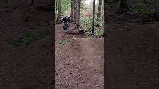
An incredibly smooth trail with golden (peanut butter) dirt

Access Info

Head down heritage boulevard and take a right into the forest between the lights, right after a power box. Take a left after first two jumps

This trail is unsanctioned.

Recent Activity on Trail

Past Week
  • 0 rides
  •  
6 Months
  • 8 rides
  • 9 miles avg distance
All
  • 141 rides
  • Last: Apr 22, 2026
c1c2c3c4
January
February
March
April
May
June
July
August
September
October
November
December
update trails status or condition

Peanut Butter Trail Reports

statusdatedescription
Mar 18, 2026 @ 3:39pm (America/Vancouver)
Mar 18, 2026
Tree down near top of trail. Chainsaw needed.
Jan 19, 2026 @ 5:12pm (America/Vancouver)
Jan 19, 2026
reporter Left line is now clear. Thanks to whoever rolled away the section of cut out log!
Jan 12, 2026 @ 1:35pm (America/Vancouver)
Jan 12, 2026
reporter Unfortunately we broke off the tip of our Silky Katanaboy folding saw while cutting through the tree mentioned in the previous post. The tree is...
Dec 19, 2025 @ 8:04am (America/Vancouver)
Dec 19, 2025
Trail closed until someone can get in there with a chainsaw. There is a very large tree across all three lines (left, middle, right) at waist to...
Jul 9, 2025 @ 8:17pm
Jul 9, 2025
more »
Status:
on Mar 18, 2026
Avg: 4.66 (16 votes)
Your vote: 0

view (821)
close
3D
Trail Conditions
  • Unknown
  • Snow Groomed
  • Snow Packed
  • Snow Covered
  • Snow Cover Partial
  • Freeze/thaw Cycle
  • Icy
  • Prevalent Mud
  • Wet
  • Variable
  • Ideal
  • Dry
  • Very Dry
Trail Flow (Ridden Direction)
Trailforks scans users ridelogs to determine the most popular direction each trail is ridden. A good flowing trail network will have most trails flowing in a single direction according to their intension.
The colour categories are based on what percentage of riders are riding a trail in its intended direction.
  • > 96%
  • > 90%
  • > 80%
  • > 70%
  • > 50%
  • < 50%
  • bi-directional trail
  • no data
Trail Last Ridden
Trailforks scans ridelogs to determine the last time a trail was ridden.
  • < 2 days
  • < 1 week
  • < 2 weeks
  • < 1 month
  • < 6 months
  • > 6 months
Trail Ridden Direction
The intended direction a trail should be ridden.
  • Downhill Only
  • Downhill Primary
  • Both Directions
  • Uphill Primary
  • Uphill Only
  • One Direction
Contribute Details
Colors indicate trail is missing specified detail.
  • Description
  • Photos
  • Description & Photos
  • Videos
Trail Popularity ?
Trailforks scans ridelogs to determine which trails are ridden the most in the last 9 months. Trails are compared with nearby trails in the same city region with a possible 25 colour shades. Think of this as a heatmap, more rides = more kinetic energy = warmer colors.
  • most popular
  • popular
  • less popular
  • not popular
ATV/ORV/OHV Filter
Max Vehicle Width
inches
US Cell Coverage
Legend
cell carrier legend

Radar Time
Activity Recordings
Trailforks uses anonymized public activity data. ?
Activity Recordings
Trailforks uses anonymized public activity data. ?
Personal Heatmap
Activity Types
all / none
Options
2
Date range month
Winter Trails
Warning A routing network for winter maps does not exist. Selecting trails using the winter trails layer has been disabled.
Missing Trails
Most Popular
Least Popular
Trails are colored based on popularity. The more popular a trail is, the more red. Less popular trails trend towards green.
Jump Magnitude Heatmap
Heatmap of where riders jump on trails. Zoom in to see individual jumps, click circles to view jump details.
BC Backroad Status

Service Road Atlas is a free to use, community-driven service for viewing and creating reports on the numerous back-country service roads around B.C. and Alberta.

map legend
Slope Aspect
Direction the slope faces
Flat N NE E SE S SW W NW
Trails Deemphasized
Trails are shown in grey.
disable
Only show trails with no bike usage.
Enable
Suggested Layers
Based on selected activity type

    Save the current map location and zoom level as your default home location whenever this page is loaded.

    Save
        Directions to peanut-butter trailhead (49.291090, -122.833680)

        Photos

        44 more »
        400 |
        Aug 23, 2017 @ 8:46pm
        Aug 23, 2017
        589 |
        May 29, 2017 @ 9:44pm
        May 29, 2017
        93 |
        Jul 30, 2023 @ 12:13am
        Jul 30, 2023
        56 |
        Jul 16, 2023 @ 2:11pm
        Jul 16, 2023

        Videos

        12 more »
        First time recording with my new GoPro
        0:47 | 317 | Mar 4, 2024 , Port Moody
        Peanut Butter
        0:04 | 199 | Feb 28, 2024 , Port Moody
        Peanut Butter Laps - Bert Flinn
        0:26 | 243 | Oct 25, 2023 , Port Moody
        Mountain biking trails with tons of flow
        3:43 | 315 | Oct 12, 2023 , Port Moody

        Trail Lists

        15 Reviews & Comments


        We hope you've been enjoying Trailforks!

        Create a FREE account to view trail comments and much more.

        • #37002 - 8,513 views

        Frequently Asked Questions About Peanut Butter

        Where is Peanut Butter located?
        Peanut Butter is located in Port Moody, British Columbia, Canada. It is part of the Port Moody trail network. The trailhead is located at coordinates 49.29109, -122.83368.
        How hard is Peanut Butter?
        Peanut Butter is rated as Black Diamond difficulty. The physical rating is Easy. The average grade is 9.4%. The climb difficulty is rated Blue.
        What is the elevation gain for Peanut Butter?
        The trail has 85 ft of elevation descent. The elevation ranges from 211 ft to 296 ft.
        Is Peanut Butter a point to point trail?
        Peanut Butter is not a point to point trail. The direction is Downhill Primary. The trail type is singletrack.

        Hit the Trail

        Open in App

        Get this trail on your phone instantly.
        open trail in app

        Download Trail

        Save to wishlist, Garmin & download.
        save the trail

        Find Related Routes

        Find routes and users activities that include this trail.
        find routes for this trail

        You must enter a description before submitting.