more stats
5.7 miles
Distance
220 ft
Climb
-29 ft
Descent
01:26:09
Avg time
192 ft
Altitude change
4,986 ft
Altitude min
5,200 ft
Altitude max
4,988 ft
Altitude start
5,180 ft
Altitude end
0.6%
Grade
-5.2%
Grade max
14.8%
Grade min
4 miles
Distance climb
1 mile
Distance down
3,780 ft
Distance flat
01:26:09
Avg time

Peavine Details

  • Activities
    • Mountain Bike
    • E-Bike
    • Gravel Bike
    • Hike
    • Trail Running
  • Riding Area
    Granite Dells
    Prescott, Arizona
  • Difficulty Rating
  • Local Popularity
    55 in Mountain Biking [+]
    • 30 in E-Biking
    • 5 in Trail Running
    • 35 in Hiking
  • Global Ranking
    #85284 in Mountain Biking [+]
    • #130098 in Trail Running
    • #123093 in Hiking
  • Hiking SAC Scale
    T1 Hiking
  • Trail Type
    Singletrack
  • Direction
    Both Directions[+]
    • Both Directions for Gravel Biking
  • Climb Difficulty
    Green
  • Physical Rating
    Easy
  • Dogs Allowed
    Yes
  • eBike Allowed
    Yes up to Class 1
  • Land Owner
    City of Prescott

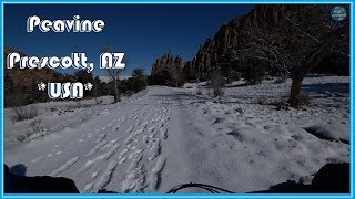
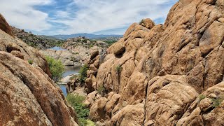
This is one of the few "Rail to Trail" projects in Arizona. There are outstanding views of Watson Lake and Granite Dells, as well as wildlife viewing.

Walk, hike, bike or horseback along this six mile trail that was originally built by the Santa Fe Railway in 1893. The Peavine connects with the Iron King Trail for another four mile trek along more railroad bed.

Take Hwy 89 to Prescott Lakes Parkway, then to Sundog Ranch Road. Shown on the NE Prescott Trails Map. Parking at the Peavine Trailhead off Prescott Lakes Parkway has a $2 fee. Alternatively, you can access this trail for free off of Hwy 89A at Side Road, from Prescott Valley Iron King trailhead, or from the trailhead on Granite Dells Road.

Local Trail Association
Traditionally Indigenous Territory

Recent Activity on Trail

Past Week
  • 0 rides
  •  
6 Months
  • 3 rides
  • 24 miles avg distance
All
  • 24 rides
  • Last: Jun 14, 2026
c1c2c3c4
January
February
March
April
May
June
July
August
September
October
November
December
update trails status or condition

Peavine Trail Reports

statusdatedescription
Nov 6, 2025 @ 8:49am (America/Phoenix)
Nov 6, 2025
Sep 8, 2024 @ 7:13am
Sep 8, 2024
reporter
Jan 6, 2022 @ 3:45pm
Jan 6, 2022
From the 'Y' towards Iron King is slop. It's passable but you'll be washing bike after. From 'Y' to 89A is good. From humane society to 'Y' is wet...
Jul 21, 2019 @ 8:40pm
Jul 21, 2019
May 23, 2017 @ 5:59am
May 23, 2017
more »
Status:
on Nov 6, 2025
Ideal
Avg: 3.88 (3 votes)
Your vote: 0

view (189)
close
3D
Trail Conditions
  • Unknown
  • Snow Groomed
  • Snow Packed
  • Snow Covered
  • Snow Cover Partial
  • Freeze/thaw Cycle
  • Icy
  • Prevalent Mud
  • Wet
  • Variable
  • Ideal
  • Dry
  • Very Dry
Trail Flow (Ridden Direction)
Trailforks scans users ridelogs to determine the most popular direction each trail is ridden. A good flowing trail network will have most trails flowing in a single direction according to their intension.
The colour categories are based on what percentage of riders are riding a trail in its intended direction.
  • > 96%
  • > 90%
  • > 80%
  • > 70%
  • > 50%
  • < 50%
  • bi-directional trail
  • no data
Trail Last Ridden
Trailforks scans ridelogs to determine the last time a trail was ridden.
  • < 2 days
  • < 1 week
  • < 2 weeks
  • < 1 month
  • < 6 months
  • > 6 months
Trail Ridden Direction
The intended direction a trail should be ridden.
  • Downhill Only
  • Downhill Primary
  • Both Directions
  • Uphill Primary
  • Uphill Only
  • One Direction
Contribute Details
Colors indicate trail is missing specified detail.
  • Description
  • Photos
  • Description & Photos
  • Videos
Trail Popularity ?
Trailforks scans ridelogs to determine which trails are ridden the most in the last 9 months. Trails are compared with nearby trails in the same city region with a possible 25 colour shades. Think of this as a heatmap, more rides = more kinetic energy = warmer colors.
  • most popular
  • popular
  • less popular
  • not popular
ATV/ORV/OHV Filter
Max Vehicle Width
inches
US Cell Coverage
Legend
cell carrier legend

Radar Time
Activity Recordings
Trailforks uses anonymized public activity data. ?
Activity Recordings
Trailforks uses anonymized public activity data. ?
Personal Heatmap
Activity Types
all / none
Options
2
Date range month
Winter Trails
Warning A routing network for winter maps does not exist. Selecting trails using the winter trails layer has been disabled.
Missing Trails
Most Popular
Least Popular
Trails are colored based on popularity. The more popular a trail is, the more red. Less popular trails trend towards green.
Jump Magnitude Heatmap
Heatmap of where riders jump on trails. Zoom in to see individual jumps, click circles to view jump details.
BC Backroad Status

Service Road Atlas is a free to use, community-driven service for viewing and creating reports on the numerous back-country service roads around B.C. and Alberta.

map legend
Slope Aspect
Direction the slope faces
Flat N NE E SE S SW W NW
Trails Deemphasized
Trails are shown in grey.
disable
Only show trails with no bike usage.
Enable
Suggested Layers
Based on selected activity type

    Save the current map location and zoom level as your default home location whenever this page is loaded.

    Save
        Directions to peavine trailhead (34.636220, -112.402360)

        Photos

        39 more »
        52 |
        May 10, 2025 @ 3:45pm
        May 10, 2025
        52 |
        May 10, 2025 @ 3:45pm
        May 10, 2025
        104 |
        Aug 26, 2023 @ 9:57am
        Aug 26, 2023
        86 |
        Aug 26, 2023 @ 9:57am
        Aug 26, 2023

        Videos

        2 more »
        Peavine Trail Prescott, AZ Mountain Biking Arizona
        13:06 | 571 | Jan 22, 2020 , Prescott
        Prescott, AZ - Thumb Butte/Watson Lake -...
        6:59 | 366 | Dec 9, 2019 , Prescott

        Routes with this trail

        103 miles 11,196 ft 178
        Prescott Circle Trail with many add-ons. Likely a great Bikepacking adventure to sample all that Prescott...
        26 miles 2,621 ft 17
        396 to Dog Park 1/2 Circle Trail
        7 miles 467 ft 9
        Green and Blue and a little bit of Black

        Reviews / Comments

        No reviews yet, be the first to write a review or ask a question.
        Use trail reports to comment on trail conditions.


        We hope you've been enjoying Trailforks!

        Create a FREE account to view trail comments and much more.

        • By toddTF Pro Trailforks & contributors
        • #14669 - 7,222 views

        Frequently Asked Questions About Peavine

        Where is Peavine located?
        Peavine is located in Granite Dells, Prescott, Arizona, United States. It is part of the Granite Dells trail network. The trailhead is located at coordinates 34.63622, -112.40236.
        How hard is Peavine?
        Peavine is rated as Green difficulty. The physical rating is Easy. The average grade is 0.6%. The climb difficulty is rated Green.
        What is the elevation gain for Peavine?
        Peavine has 220 ft of elevation gain. The trail has 29 ft of elevation descent. The elevation ranges from 4,986 ft to 5,200 ft.
        Is Peavine a point to point trail?
        Peavine is not a point to point trail. The direction is Both Directions. The trail type is singletrack.

        Hit the Trail

        Open in App

        Get this trail on your phone instantly.
        open trail in app

        Download Trail

        Save to wishlist, Garmin & download.
        save the trail

        Find Related Routes

        Find routes and users activities that include this trail.
        find routes for this trail

        You must enter a description before submitting.