more stats
2,608 ft
Distance
136 ft
Climb
00:04:43
Avg time
137 ft
Altitude change
101 ft
Altitude min
239 ft
Altitude max
101 ft
Altitude start
240 ft
Altitude end
5.3%
Grade
0.9%
Grade max
10.8%
Grade min
2,608 ft
Distance climb
00:04:43
Avg time

Pershing Climb Details

  • Activities
    • Mountain Bike
    • Hike
    • Trail Running
  • Riding Area
    Balboa Park
    San Diego, California
  • Difficulty Rating
  • Local Popularity
    95 in Mountain Biking [+]
    • 90 in Trail Running
    • 70 in Hiking
  • Global Ranking
    #85583 in Mountain Biking [+]
    • #38278 in Trail Running
    • #84898 in Hiking
  • Trail Type
    Singletrack
  • Bike Type
    XC
  • Direction
    Uphill Primary
    Popular Direction Shown
  • Climb Difficulty
    Blue
  • Physical Rating
    Moderate
  • Trail Visibility
    Always easy to follow
  • Dogs Allowed
    Yes
  • Land Owner
    City of San Diego

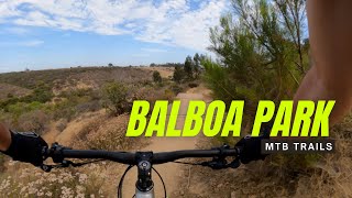
A primarily climbing trail immediately next to Pershing Dr. The exposure and proximity to traffic can increase the psychological challenge.

Be careful of the bolts sticking out of the guardrail posts. They're at knee/shin level and will cause serious damage if struck.

Local Trail Association
Traditionally Indigenous Territory

Recent Activity on Trail

Past Week
  • 6 rides
  • 11 miles average
6 Months
  • 121 rides
  • 10 miles avg distance
All
  • 685 rides
  • Last: Jun 17, 2026
c1c2c3c4
January
February
March
April
May
June
July
August
September
October
November
December
update trails status or condition

Pershing Climb Trail Reports

statusdatedescription
Mar 10, 2025 @ 8:50am
Mar 10, 2025
Aug 24, 2023 @ 1:08am
Aug 24, 2023
Bees are still there. I'll usually go around this part by stepping over the guard rail then get on the paved bike lane for 50ft, then get back...
Apr 18, 2023 @ 2:23am
Apr 18, 2023
Grass/brush is very tall so dirt trail is overgrown and hard to ride
Nov 5, 2022 @ 5:00am
Nov 5, 2022
Bee hive still present but not super active Brush has been cut back (thank you)
Jul 26, 2022 @ 12:04pm
Jul 26, 2022
***CAUTION***Underground Bee hive @ 32.72417° N, 117.14245° W Very large and active bee hive present in what appears to be a gopher hole....
more »
Status:
on Mar 10, 2025
Ideal
Avg: 3.29 (4 votes)
Your vote: 0

view (5,059)
close
3D
Trail Conditions
  • Unknown
  • Snow Groomed
  • Snow Packed
  • Snow Covered
  • Snow Cover Partial
  • Freeze/thaw Cycle
  • Icy
  • Prevalent Mud
  • Wet
  • Variable
  • Ideal
  • Dry
  • Very Dry
Trail Flow (Ridden Direction)
Trailforks scans users ridelogs to determine the most popular direction each trail is ridden. A good flowing trail network will have most trails flowing in a single direction according to their intension.
The colour categories are based on what percentage of riders are riding a trail in its intended direction.
  • > 96%
  • > 90%
  • > 80%
  • > 70%
  • > 50%
  • < 50%
  • bi-directional trail
  • no data
Trail Last Ridden
Trailforks scans ridelogs to determine the last time a trail was ridden.
  • < 2 days
  • < 1 week
  • < 2 weeks
  • < 1 month
  • < 6 months
  • > 6 months
Trail Ridden Direction
The intended direction a trail should be ridden.
  • Downhill Only
  • Downhill Primary
  • Both Directions
  • Uphill Primary
  • Uphill Only
  • One Direction
Contribute Details
Colors indicate trail is missing specified detail.
  • Description
  • Photos
  • Description & Photos
  • Videos
Trail Popularity ?
Trailforks scans ridelogs to determine which trails are ridden the most in the last 9 months. Trails are compared with nearby trails in the same city region with a possible 25 colour shades. Think of this as a heatmap, more rides = more kinetic energy = warmer colors.
  • most popular
  • popular
  • less popular
  • not popular
ATV/ORV/OHV Filter
Max Vehicle Width
inches
US Cell Coverage
Legend
cell carrier legend

Radar Time
Activity Recordings
Trailforks uses anonymized public activity data. ?
Activity Recordings
Trailforks uses anonymized public activity data. ?
Personal Heatmap
Activity Types
all / none
Options
2
Date range month
Winter Trails
Warning A routing network for winter maps does not exist. Selecting trails using the winter trails layer has been disabled.
Missing Trails
Most Popular
Least Popular
Trails are colored based on popularity. The more popular a trail is, the more red. Less popular trails trend towards green.
Jump Magnitude Heatmap
Heatmap of where riders jump on trails. Zoom in to see individual jumps, click circles to view jump details.
BC Backroad Status

Service Road Atlas is a free to use, community-driven service for viewing and creating reports on the numerous back-country service roads around B.C. and Alberta.

map legend
Slope Aspect
Direction the slope faces
Flat N NE E SE S SW W NW
Trails Deemphasized
Trails are shown in grey.
disable
Only show trails with no bike usage.
Enable
Suggested Layers
Based on selected activity type

    Save the current map location and zoom level as your default home location whenever this page is loaded.

    Save
        Directions to pershing-climb trailhead (32.722990, -117.142660)

        Photos

        No photos have been added for Pershing Climb yet, add a photo.

        Videos

        2 more »
        Balboa Park MTB
        22:40 | 190 | Jul 13, 2021 , San Diego
        POV of Pershing Climb
        2:13 | 80 | Aug 21, 2020 , San Diego

        Routes with this trail

        5.0 5 miles 426 ft 10 Loop
        The Cactus Enduro Loop is a moderately challenging enduro style loop that incorporates two climbs and two...
        3.0 5 miles 504 ft 15 Loop
        In these , it can be challenging to find time for a long, epic ride. Sometimes, a quick fix is in order...
        2.4 10 miles 1,202 ft 21 Loop
        Let's establish one thing straight away: this ain't Moab. The route herein is nothing like . If anything,...

        2 Reviews & Comments


        We hope you've been enjoying Trailforks!

        Create a FREE account to view trail comments and much more.

        • By LiveFastPedalHard & contributors
        • #307762 - 1,012 views

        Frequently Asked Questions About Pershing Climb

        Where is Pershing Climb located?
        Pershing Climb is located in Balboa Park, San Diego, California, United States. It is part of the Balboa Park trail network. The trailhead is located at coordinates 32.72299, -117.14266.
        How hard is Pershing Climb?
        Pershing Climb is rated as Blue difficulty. The physical rating is Moderate. The average grade is 5.3%. The climb difficulty is rated Blue.
        What is the elevation gain for Pershing Climb?
        Pershing Climb has 136 ft of elevation gain. The elevation ranges from 101 ft to 239 ft.
        Is Pershing Climb a point to point trail?
        Pershing Climb is not a point to point trail. The direction is Uphill Primary. The trail type is singletrack.

        Hit the Trail

        Open in App

        Get this trail on your phone instantly.
        open trail in app

        Download Trail

        Save to wishlist, Garmin & download.
        save the trail

        Find Related Routes

        Find routes and users activities that include this trail.
        find routes for this trail

        You must enter a description before submitting.