more stats
2.7 miles
Distance
29 ft
Climb
-1,062 ft
Descent
00:19:54
Avg time
-1,032 ft
Altitude change
2,782 ft
Altitude min
3,814 ft
Altitude max
3,814 ft
Altitude start
2,782 ft
Altitude end
-7.3%
Grade
-30.2%
Grade max
15.3%
Grade min
587 ft
Distance climb
2 miles
Distance down
1,808 ft
Distance flat
00:19:54
Avg time

Pete's Dragon Details

  • Activities
    • Mountain Bike
    • Hike
    • Trail Running
  • Riding Area
    Sun Mountain
    Winthrop, Washington
  • Difficulty Rating
  • Voted Difficulty
    Blue (3 votes)
  • Local Popularity
    95 in Mountain Biking [+]
    • 70 in Trail Running
    • 70 in Hiking
  • Global Ranking
    #17016 in Mountain Biking [+]
    • #19887 in Trail Running
    • #22172 in Hiking
  • Trail Type
    Singletrack
  • Bike Type
    AM
  • Direction
    Downhill Only
    Popular Direction Shown
  • Dogs Allowed
    Yes
  • eBike Allowed
  • TTFs on Trail
    Berm, Drop, Jump
  • Land Owner

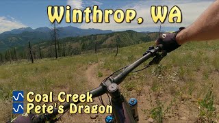
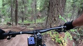
Pete's Dragon is the trail to ride in the Sun Mountain area. A must-ride trial that has well-built berms and plenty of rollable features that will make riders of all abilities smile. The trail has three distinct sections (upper, middle, and Lower) which each have their own character. The Evergreen crew has been improving Pete's Dragon for the last several years. Petes is a downhill trail only.

Trail Supporters

  • USFS
    Land Manager
Local Trail Association

Recent Activity on Trail

Past Week
  • 3 rides
  • 8 miles average
6 Months
  • 33 rides
  • 11 miles avg distance
All
  • 347 rides
  • Last: Jun 20, 2026
c1c2c3c4
January
February
March
April
May
June
July
August
September
October
November
December
update trails status or condition

Pete's Dragon Trail Reports

statusdatedescription
May 1, 2026 @ 8:29am (America/Los_Angeles)
May 1, 2026
Cleared of down trees by EMBA crew and ready to ride. As always, look out for more trees coming down especially after windy days.
Apr 27, 2026 @ 6:58pm (America/Los_Angeles)
Apr 27, 2026
Down tree. Half way up upper Pete’s.
Apr 17, 2026 @ 6:41pm (America/Los_Angeles)
Apr 17, 2026
Heavy tree blowdown has been cleared by the EMBA/Trails Collaborative crew. Some debris is left on the trail, and new trees are falling with every...
Apr 2, 2026 @ 3:47pm (America/Los_Angeles)
Apr 2, 2026
Significant snow, mud and downed trees. A few weeks out at least before it's rideable.
Oct 30, 2025 @ 6:30pm (America/Los_Angeles)
Oct 30, 2025
greasy/mud up higher
more »
Status:
on May 1, 2026
Freeze/thaw Cycle
Avg: 4.53 (32 votes)
Your vote: 0

view (1,162)
close
3D
Trail Conditions
  • Unknown
  • Snow Groomed
  • Snow Packed
  • Snow Covered
  • Snow Cover Partial
  • Freeze/thaw Cycle
  • Icy
  • Prevalent Mud
  • Wet
  • Variable
  • Ideal
  • Dry
  • Very Dry
Trail Flow (Ridden Direction)
Trailforks scans users ridelogs to determine the most popular direction each trail is ridden. A good flowing trail network will have most trails flowing in a single direction according to their intension.
The colour categories are based on what percentage of riders are riding a trail in its intended direction.
  • > 96%
  • > 90%
  • > 80%
  • > 70%
  • > 50%
  • < 50%
  • bi-directional trail
  • no data
Trail Last Ridden
Trailforks scans ridelogs to determine the last time a trail was ridden.
  • < 2 days
  • < 1 week
  • < 2 weeks
  • < 1 month
  • < 6 months
  • > 6 months
Trail Ridden Direction
The intended direction a trail should be ridden.
  • Downhill Only
  • Downhill Primary
  • Both Directions
  • Uphill Primary
  • Uphill Only
  • One Direction
Contribute Details
Colors indicate trail is missing specified detail.
  • Description
  • Photos
  • Description & Photos
  • Videos
Trail Popularity ?
Trailforks scans ridelogs to determine which trails are ridden the most in the last 9 months. Trails are compared with nearby trails in the same city region with a possible 25 colour shades. Think of this as a heatmap, more rides = more kinetic energy = warmer colors.
  • most popular
  • popular
  • less popular
  • not popular
ATV/ORV/OHV Filter
Max Vehicle Width
inches
US Cell Coverage
Legend
cell carrier legend

Radar Time
Activity Recordings
Trailforks uses anonymized public activity data. ?
Activity Recordings
Trailforks uses anonymized public activity data. ?
Personal Heatmap
Activity Types
all / none
Options
2
Date range month
Winter Trails
Warning A routing network for winter maps does not exist. Selecting trails using the winter trails layer has been disabled.
Missing Trails
Most Popular
Least Popular
Trails are colored based on popularity. The more popular a trail is, the more red. Less popular trails trend towards green.
Jump Magnitude Heatmap
Heatmap of where riders jump on trails. Zoom in to see individual jumps, click circles to view jump details.
BC Backroad Status

Service Road Atlas is a free to use, community-driven service for viewing and creating reports on the numerous back-country service roads around B.C. and Alberta.

map legend
Slope Aspect
Direction the slope faces
Flat N NE E SE S SW W NW
Trails Deemphasized
Trails are shown in grey.
disable
Only show trails with no bike usage.
Enable
Suggested Layers
Based on selected activity type

    Save the current map location and zoom level as your default home location whenever this page is loaded.

    Save
        Directions to pete-s-dragon-66481 trailhead (48.432380, -120.270810)

        Photos

        11 more »
        114 |
        Oct 5, 2025 @ 9:20am
        Oct 5, 2025
        122 |
        Oct 5, 2025 @ 9:20am
        Oct 5, 2025
        85 |
        Sep 13, 2025 @ 9:21am
        Sep 13, 2025
        109 |
        Jun 27, 2024 @ 4:58pm
        Jun 27, 2024

        Videos

        3 more »
        Whistler Jumps in Wenatchee?
        343 | Oct 9, 2023 , Winthrop
        youtuber Coal Creek and Pete's Dragon
        10:12 | 775 | Aug 6, 2022 , Winthrop
        Pete's Dragon 9/13/2019 Sun Mountain
        13:58 | 1903 | Oct 21, 2019 , Winthrop

        Trail Lists

        Routes with this trail

        6 miles 1,012 ft 7
        This is one of our favorite flow routes in the Methow Valley and is featured in Freehub Magazine's North...
        8 miles 778 ft 18
        Stage 1 of Terry's Big Idea #3 Fundraiser

        16 Reviews & Comments


        We hope you've been enjoying Trailforks!

        Create a FREE account to view trail comments and much more.

        • By Hbrown15TF Pro & contributors
        • #66481 - 10,486 views

        Frequently Asked Questions About Pete's Dragon

        Where is Pete's Dragon located?
        Pete's Dragon is located in Sun Mountain, Winthrop, Washington, United States. It is part of the Sun Mountain trail network. The trailhead is located at coordinates 48.43238, -120.27081.
        How hard is Pete's Dragon?
        Pete's Dragon is rated as Blue difficulty. The average grade is 7.3%.
        What is the elevation gain for Pete's Dragon?
        Pete's Dragon has 29 ft of elevation gain. The trail has 1,062 ft of elevation descent. The elevation ranges from 2,782 ft to 3,814 ft.
        Is Pete's Dragon a point to point trail?
        Yes, Pete's Dragon is a point to point trail. The direction is Downhill Only. The trail type is singletrack.

        Hit the Trail

        Open in App

        Get this trail on your phone instantly.
        open trail in app

        Download Trail

        Save to wishlist, Garmin & download.
        save the trail

        Find Related Routes

        Find routes and users activities that include this trail.
        find routes for this trail

        You must enter a description before submitting.