more stats
1,109 ft
Distance
-68 ft
Descent
515 ft
High Point
-68 ft
Altitude change
447 ft
Altitude min
515 ft
Altitude start
446 ft
Altitude end
-6.1%
Grade
-14.5%
Grade max
978 ft
Distance down
131 ft
Distance flat

Philharmonic Airwaves Details

  • Activities
    • Mountain Bike
    • E-Bike
  • Riding Area
    Wilderness Tours Bike Park
    Beachburg, Ontario
  • Ref Number
    #43
  • Difficulty Rating
  • Local Popularity
    80 in Mountain Biking [+]
    • 70 in E-Biking
  • Trail Type
    Singletrack
  • Bike Type
    DH, AM, DJ
  • Climb Difficulty
    Double Black Diamond
  • Physical Rating
    Extreme
  • Trail Visibility
    Always easy to follow
  • Season
    Spring - Fall
  • eBike Allowed
  • TTFs on Trail
    Berm, Drop, Jump, Rock Face, Wallride
  • Year Opened
    2025
  • Land Owner

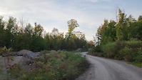
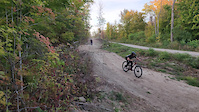
This is a sendy addition to the skills area that starts at the high point on the property and runs all the way to the skills area. High speed, jumps, gaps, whale tails are in your future when riding this addition to the Wilderness Tours Bike Park

Trail Supporters

Bike Park

Recent Activity on Trail

Past Week
  • 1 rides
  • 14 miles average
6 Months
  • 29 rides
  • 9 miles avg distance
All
  • 126 rides
  • Last: Jun 20, 2026
c1c2c3c4
January
February
March
April
May
June
July
August
September
October
November
December
update trails status or condition

Philharmonic... Trail Reports

statusdatedescription
May 24, 2026 @ 8:59am (America/Toronto)
May 24, 2026
reporter
Whipper snipped
Oct 22, 2025 @ 9:58pm (America/Toronto)
Oct 22, 2025
reporter
Leaves cleared
more »
Status:
on May 24, 2026
Wet
no votes yet
Your vote: 0

view (276)
close
3D
Trail Conditions
  • Unknown
  • Snow Groomed
  • Snow Packed
  • Snow Covered
  • Snow Cover Partial
  • Freeze/thaw Cycle
  • Icy
  • Prevalent Mud
  • Wet
  • Variable
  • Ideal
  • Dry
  • Very Dry
Trail Flow (Ridden Direction)
Trailforks scans users ridelogs to determine the most popular direction each trail is ridden. A good flowing trail network will have most trails flowing in a single direction according to their intension.
The colour categories are based on what percentage of riders are riding a trail in its intended direction.
  • > 96%
  • > 90%
  • > 80%
  • > 70%
  • > 50%
  • < 50%
  • bi-directional trail
  • no data
Trail Last Ridden
Trailforks scans ridelogs to determine the last time a trail was ridden.
  • < 2 days
  • < 1 week
  • < 2 weeks
  • < 1 month
  • < 6 months
  • > 6 months
Trail Ridden Direction
The intended direction a trail should be ridden.
  • Downhill Only
  • Downhill Primary
  • Both Directions
  • Uphill Primary
  • Uphill Only
  • One Direction
Contribute Details
Colors indicate trail is missing specified detail.
  • Description
  • Photos
  • Description & Photos
  • Videos
Trail Popularity ?
Trailforks scans ridelogs to determine which trails are ridden the most in the last 9 months. Trails are compared with nearby trails in the same city region with a possible 25 colour shades. Think of this as a heatmap, more rides = more kinetic energy = warmer colors.
  • most popular
  • popular
  • less popular
  • not popular
ATV/ORV/OHV Filter
Max Vehicle Width
inches
US Cell Coverage
Legend
cell carrier legend

Radar Time
Activity Recordings
Trailforks uses anonymized public activity data. ?
Activity Recordings
Trailforks uses anonymized public activity data. ?
Personal Heatmap
Activity Types
all / none
Options
2
Date range month
Winter Trails
Warning A routing network for winter maps does not exist. Selecting trails using the winter trails layer has been disabled.
Missing Trails
Most Popular
Least Popular
Trails are colored based on popularity. The more popular a trail is, the more red. Less popular trails trend towards green.
Jump Magnitude Heatmap
Heatmap of where riders jump on trails. Zoom in to see individual jumps, click circles to view jump details.
BC Backroad Status

Service Road Atlas is a free to use, community-driven service for viewing and creating reports on the numerous back-country service roads around B.C. and Alberta.

map legend
Slope Aspect
Direction the slope faces
Flat N NE E SE S SW W NW
Trails Deemphasized
Trails are shown in grey.
disable
Only show trails with no bike usage.
Enable
Suggested Layers
Based on selected activity type

    Save the current map location and zoom level as your default home location whenever this page is loaded.

    Save
        Directions to philharmonic-airwaves trailhead (45.716350, -76.733910)

        Photos

        8 more »
        77 |
        Sep 16, 2025 @ 5:23pm
        Sep 16, 2025
        95 |
        Sep 16, 2025 @ 5:13pm
        Sep 16, 2025
        73 |
        Sep 16, 2025 @ 5:13pm
        Sep 16, 2025
        66 |
        Sep 16, 2025 @ 5:13pm
        Sep 16, 2025

        Videos

        2 more »
        Trail Crew Test Laps
        0:26 | 36 | Sep 17, 2025 , Beachburg
        Test Laps
        0:11 | 18 | Sep 17, 2025 , Beachburg

        Routes with this trail

        8 miles 1,164 ft 29
        The route for the 2025 Ottawa River Enduro. 6 stages with 7th mystery stage :-)

        Reviews / Comments

        No reviews yet, be the first to write a review or ask a question.
        Use trail reports to comment on trail conditions.


        We hope you've been enjoying Trailforks!

        Create a FREE account to view trail comments and much more.

        • By Sharkyh2oTF Pro WT & contributors
        • #835490 - 329 views

        Frequently Asked Questions About Philharmonic Airwaves

        Where is Philharmonic Airwaves located?
        Philharmonic Airwaves is located in Wilderness Tours Bike Park, Beachburg, Ontario, Canada. It is part of the Wilderness Tours Bike Park trail network. The trailhead is located at coordinates 45.71635, -76.73391.
        How hard is Philharmonic Airwaves?
        Philharmonic Airwaves is rated as Double Black Diamond difficulty. The physical rating is Extreme. The average grade is 6.1%. The climb difficulty is rated Double Black Diamond.
        What is the elevation gain for Philharmonic Airwaves?
        The trail has 68 ft of elevation descent. The elevation ranges from 447 ft to 515 ft.
        How long is Philharmonic Airwaves?
        Philharmonic Airwaves is 1,109 ft long. The trail type is singletrack.

        Hit the Trail

        Open in App

        Get this trail on your phone instantly.
        open trail in app

        Download Trail

        Save to wishlist, Garmin & download.
        save the trail

        Find Related Routes

        Find routes and users activities that include this trail.
        find routes for this trail

        You must enter a description before submitting.