more stats
5.1 miles
Distance
990 ft
Climb
-19 ft
Descent
00:59:22
Avg time
970 ft
Altitude change
5,401 ft
Altitude min
6,372 ft
Altitude max
5,402 ft
Altitude start
6,371 ft
Altitude end
3.6%
Grade
-7.3%
Grade max
21.5%
Grade min
5 miles
Distance climb
1,532 ft
Distance down
899 ft
Distance flat
00:59:22
Avg time

Picture Rock Details

  • Activities
    • Mountain Bike
    • Hike
    • Trail Running
  • Riding Area
    Heil Valley Ranch
    Lyons, Colorado
  • Difficulty Rating
  • Local Popularity
    85 in Mountain Biking [+]
    • 95 in Trail Running
    • 65 in Hiking
  • Global Ranking
    #41164 in Mountain Biking [+]
    • #3117 in Trail Running
    • #81783 in Hiking
  • Trail Type
    Singletrack
  • Bike Type
    AM, XC
  • Direction
    Both Directions
  • Climb Difficulty
    Blue
  • Physical Rating
    Moderate
  • eBike Allowed
  • TTFs on Trail
    Berm, Rock Face
  • Land Owner
    Boulder County Parks & Open Space

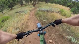
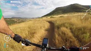
Picture Rock is a critical link trail out of Lyons. It's insanely popular, but for a good reason. Want to ride out of town and do some miles and come back for a beer? This trail has your name on it It's sort of a Jekyll and Hyde trail. The bottom half (after an impressive boulder "gate" that signals the beginning of the real trail) is a smooth as butter swoop-fest. Climb is easy with great views and the trails is wonderful for beginning riders. Pass "the silo" (that's a big round tower for you folks visiting from cities. Sort of like Rapunzel's tower or the tower in the Dark Tower (nerd)) and it's a different beast. Still a blue climb, but now it's full of sharp pointy rocks (look at the bones!).

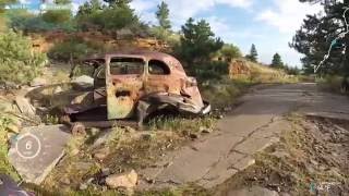
There's some great history on this trail. Right after the silo, you'll pass an old quarry with a dead car in it. There's heaps of old ranching walls (both buildings and fences) made from the local sandstone. Really cool stuff to stop and look out if you need an excuse for getting off the bike for a moment or two (don't give away my secret about this one).

Downhill is a bit choppy up at the top. When the trail was new, the rocks had a great flow to them. Now, there are enough poking through that they tend to slow you down (not necessarily a bad thing). The lower section (the aforementioned swoop-fest) is amazing on the way out. Watch out for blind turns through. There are several sections where tall bushes can obscure a hiker, or biker, or zombie horde until the last second.

Disclaimer

Picture Rock is open through the lower, undamaged area of Heil. Please respect all trail closures.

Local Trail Association

Recent Activity on Trail

Past Week
  • 3 rides
  • 22 miles average
6 Months
  • 97 rides
  • 14 miles avg distance
All
  • 700 rides
  • Last: Jun 18, 2026
c1c2c3c4
January
February
March
April
May
June
July
August
September
October
November
December
update trails status or condition

Picture Rock Trail Reports

statusdatedescription
May 22, 2026 @ 11:19am (America/Denver)
May 22, 2026
Just a few puddles
May 21, 2026 @ 5:14pm (America/Denver)
May 21, 2026
Trail is open. Please update conditions if you ride.
May 19, 2026 @ 4:43pm (America/Denver)
May 19, 2026
Closed for muddy conditions. Status will be updated when trail reopens
May 9, 2026 @ 10:26am (America/Denver)
May 9, 2026
Pristine and hero
May 8, 2026 @ 5:40pm (America/Denver)
May 8, 2026
Trail is open. Please update conditions if you ride
more »
Status:
on May 22, 2026
Variable
Avg: 3.92 (20 votes)
Your vote: 0

view (6,377)
close
3D
Trail Conditions
  • Unknown
  • Snow Groomed
  • Snow Packed
  • Snow Covered
  • Snow Cover Partial
  • Freeze/thaw Cycle
  • Icy
  • Prevalent Mud
  • Wet
  • Variable
  • Ideal
  • Dry
  • Very Dry
Trail Flow (Ridden Direction)
Trailforks scans users ridelogs to determine the most popular direction each trail is ridden. A good flowing trail network will have most trails flowing in a single direction according to their intension.
The colour categories are based on what percentage of riders are riding a trail in its intended direction.
  • > 96%
  • > 90%
  • > 80%
  • > 70%
  • > 50%
  • < 50%
  • bi-directional trail
  • no data
Trail Last Ridden
Trailforks scans ridelogs to determine the last time a trail was ridden.
  • < 2 days
  • < 1 week
  • < 2 weeks
  • < 1 month
  • < 6 months
  • > 6 months
Trail Ridden Direction
The intended direction a trail should be ridden.
  • Downhill Only
  • Downhill Primary
  • Both Directions
  • Uphill Primary
  • Uphill Only
  • One Direction
Contribute Details
Colors indicate trail is missing specified detail.
  • Description
  • Photos
  • Description & Photos
  • Videos
Trail Popularity ?
Trailforks scans ridelogs to determine which trails are ridden the most in the last 9 months. Trails are compared with nearby trails in the same city region with a possible 25 colour shades. Think of this as a heatmap, more rides = more kinetic energy = warmer colors.
  • most popular
  • popular
  • less popular
  • not popular
ATV/ORV/OHV Filter
Max Vehicle Width
inches
US Cell Coverage
Legend
cell carrier legend

Radar Time
Activity Recordings
Trailforks uses anonymized public activity data. ?
Activity Recordings
Trailforks uses anonymized public activity data. ?
Personal Heatmap
Activity Types
all / none
Options
2
Date range month
Winter Trails
Warning A routing network for winter maps does not exist. Selecting trails using the winter trails layer has been disabled.
Missing Trails
Most Popular
Least Popular
Trails are colored based on popularity. The more popular a trail is, the more red. Less popular trails trend towards green.
Jump Magnitude Heatmap
Heatmap of where riders jump on trails. Zoom in to see individual jumps, click circles to view jump details.
BC Backroad Status

Service Road Atlas is a free to use, community-driven service for viewing and creating reports on the numerous back-country service roads around B.C. and Alberta.

map legend
Slope Aspect
Direction the slope faces
Flat N NE E SE S SW W NW
Trails Deemphasized
Trails are shown in grey.
disable
Only show trails with no bike usage.
Enable
Suggested Layers
Based on selected activity type

    Save the current map location and zoom level as your default home location whenever this page is loaded.

    Save
        Directions to picture-rock trailhead (40.211340, -105.272930)

        Photos

        47 more »
        771 |
        Feb 27, 2015 @ 11:08am
        Feb 27, 2015
        20 |
        Jun 3, 2026 @ 11:49am
        Jun 3, 2026
        24 |
        Jun 3, 2026 @ 11:18am
        Jun 3, 2026
        16 |
        Jun 2, 2026 @ 2:41pm
        Jun 2, 2026

        Videos

        4 more »
        Picture Rock - Full Descent
        24:23 | 103 | Sep 4, 2025 , Lyons
        Picture Rock - Heil Valley Ranch - Lyons -...
        3:53 | 717 | Sep 7, 2021 , Lyons
        youtuber Mountain Biking at Heil Valley Ranch - Lower...
        1389 | Aug 31, 2016 , Lyons
        youtuber CO MTB  | Heil Valley Ranch - Upper Picture...
        1070 | Aug 31, 2016 , Lyons

        Routes with this trail

        Lil' Burrito Featured
        5.0 41 miles 4,953 ft 26 Out & Back
        The Little Burrito (yes, the author knows that "Burrito" is Spanish for little donkey, so this is a...
        16 miles 1,451 ft 3 Out & Back
        Starting from Lyons, this ride starts out gentle and flowy on then progressively gets rockier. Start your...
        14 miles 1,426 ft 3 Out & Back
        Picture Rock to is rated intermediate/advanced for total elevation gain, technical features and overall...

        7 Reviews & Comments


        We hope you've been enjoying Trailforks!

        Create a FREE account to view trail comments and much more.

        • By toddTF Pro Trailforks & contributors
        • #13704 - 11,249 views

        Frequently Asked Questions About Picture Rock

        Where is Picture Rock located?
        Picture Rock is located in Heil Valley Ranch, Lyons, Colorado, United States. It is part of the Heil Valley Ranch trail network. The trailhead is located at coordinates 40.21134, -105.27293.
        How hard is Picture Rock?
        Picture Rock is rated as Blue difficulty. The physical rating is Moderate. The average grade is 3.6%. The climb difficulty is rated Blue.
        What is the elevation gain for Picture Rock?
        Picture Rock has 990 ft of elevation gain. The trail has 19 ft of elevation descent. The elevation ranges from 5,401 ft to 6,372 ft.
        Is Picture Rock a point to point trail?
        Picture Rock is not a point to point trail. The direction is Both Directions. The trail type is singletrack.

        Hit the Trail

        Open in App

        Get this trail on your phone instantly.
        open trail in app

        Download Trail

        Save to wishlist, Garmin & download.
        save the trail

        Find Related Routes

        Find routes and users activities that include this trail.
        find routes for this trail

        You must enter a description before submitting.