more stats
2,507 ft
Distance
4 ft
Climb
-131 ft
Descent
00:05:23
Avg time
-128 ft
Altitude change
4,236 ft
Altitude min
4,364 ft
Altitude max
4,364 ft
Altitude start
4,236 ft
Altitude end
-5.1%
Grade
-21.8%
Grade max
7.5%
Grade min
95 ft
Distance climb
1,578 ft
Distance down
837 ft
Distance flat
00:05:23
Avg time

Pig Tail Details

  • Activities
    • Mountain Bike
    • Hike
    • Trail Running
  • Riding Area
    Broken Arrow
    Sedona, Arizona
  • Difficulty Rating
  • Voted Difficulty
    Black Diamond (4 votes)
  • Local Popularity
    95 in Mountain Biking [+]
    • 55 in Trail Running
    • 60 in Hiking
  • Global Ranking
    #690 in Mountain Biking [+]
    • #72017 in Trail Running
    • #72217 in Hiking
  • Trail Type
    Singletrack
  • Bike Type
    AM, XC, DJ
  • Climb Difficulty
    Green
  • Physical Rating
    Moderate
  • Dogs Allowed
    Yes
  • eBike Allowed

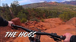
Intermediate 20 %, advanced 70% and expert 10%, .68 mile MTB trail which is a bi-directional singletrack that is a fast twisty bermed trail with feathers designed for the airborne crowd, There is a 3’ high diving board with a 20’ slab rock landing zone, several other jumps where you become airborne and a table top near the end that needs to be looked at before hit too aggressively. The trail tread is mostly packed dirt and there are sections built on solid rock through several drainages. The preferred direction definitely downhill due to fast moving downhill riders, but some riders ride it uphill so beware when riding it.

Trail Supporters
Local Trail Association

Recent Activity on Trail

Past Week
  • 1 rides
  • 37 miles average
6 Months
  • 111 rides
  • 13 miles avg distance
All
  • 1,070 rides
  • Last: Jun 23, 2026
c1c2c3c4
January
February
March
April
May
June
July
August
September
October
November
December
Status:
on Mar 24, 2026
Ideal
Avg: 4.56 (47 votes)
Your vote: 0

view (7,791)
close
3D
Trail Conditions
  • Unknown
  • Snow Groomed
  • Snow Packed
  • Snow Covered
  • Snow Cover Partial
  • Freeze/thaw Cycle
  • Icy
  • Prevalent Mud
  • Wet
  • Variable
  • Ideal
  • Dry
  • Very Dry
Trail Flow (Ridden Direction)
Trailforks scans users ridelogs to determine the most popular direction each trail is ridden. A good flowing trail network will have most trails flowing in a single direction according to their intension.
The colour categories are based on what percentage of riders are riding a trail in its intended direction.
  • > 96%
  • > 90%
  • > 80%
  • > 70%
  • > 50%
  • < 50%
  • bi-directional trail
  • no data
Trail Last Ridden
Trailforks scans ridelogs to determine the last time a trail was ridden.
  • < 2 days
  • < 1 week
  • < 2 weeks
  • < 1 month
  • < 6 months
  • > 6 months
Trail Ridden Direction
The intended direction a trail should be ridden.
  • Downhill Only
  • Downhill Primary
  • Both Directions
  • Uphill Primary
  • Uphill Only
  • One Direction
Contribute Details
Colors indicate trail is missing specified detail.
  • Description
  • Photos
  • Description & Photos
  • Videos
Trail Popularity ?
Trailforks scans ridelogs to determine which trails are ridden the most in the last 9 months. Trails are compared with nearby trails in the same city region with a possible 25 colour shades. Think of this as a heatmap, more rides = more kinetic energy = warmer colors.
  • most popular
  • popular
  • less popular
  • not popular
ATV/ORV/OHV Filter
Max Vehicle Width
inches
US Cell Coverage
Legend
cell carrier legend

Radar Time
Activity Recordings
Trailforks uses anonymized public activity data. ?
Activity Recordings
Trailforks uses anonymized public activity data. ?
Personal Heatmap
Activity Types
all / none
Options
2
Date range month
Winter Trails
Warning A routing network for winter maps does not exist. Selecting trails using the winter trails layer has been disabled.
Missing Trails
Most Popular
Least Popular
Trails are colored based on popularity. The more popular a trail is, the more red. Less popular trails trend towards green.
Jump Magnitude Heatmap
Heatmap of where riders jump on trails. Zoom in to see individual jumps, click circles to view jump details.
BC Backroad Status

Service Road Atlas is a free to use, community-driven service for viewing and creating reports on the numerous back-country service roads around B.C. and Alberta.

map legend
Slope Aspect
Direction the slope faces
Flat N NE E SE S SW W NW
Trails Deemphasized
Trails are shown in grey.
disable
Only show trails with no bike usage.
Enable
Suggested Layers
Based on selected activity type

    Save the current map location and zoom level as your default home location whenever this page is loaded.

    Save
        Directions to pig-tail trailhead (34.839140, -111.769890)

        Photos

        30 more »
        1,077 |
        Mar 19, 2015 @ 10:03am
        Mar 19, 2015
        495 |
        Jan 19, 2015 @ 9:56pm
        Jan 19, 2015
        57 |
        Jan 29, 2025 @ 7:25am
        Jan 29, 2025
        77 |
        Apr 6, 2024 @ 4:48pm
        Apr 6, 2024

        Videos

        9 more »
        Sedona Trail Guide: Pig Tail
        3:02 | 39 | Apr 11, 2026 , Sedona
        Rock Drops to Jump Flow on The HOGS
        13:44 | 59 | Apr 26, 2025 , Sedona
        Pigtail - Sedona, AZ - MTB Trail Preview
        0:54 | 116 | Mar 17, 2025 , Sedona
        Broken Arrow Sedona, Arizona
        18:34 | 351 | Aug 25, 2021 , Sedona

        Routes with this trail

        3.5 10 miles 1,100 ft 14 Loop
        This is another must do ride for the advanced rider. The ride itself is quite technical, very scenic and...
        4.0 7 miles 943 ft 8
        Even though this is a much shorter route, this ride is a step up from Hiline, with more exposure and more...
        5.0 53 miles 5,619 ft 24
        This is for the AES BFL for the year 2021

        9 Reviews & Comments


        We hope you've been enjoying Trailforks!

        Create a FREE account to view trail comments and much more.

        Nearby Trails

        • By toddTF Pro Trailforks & contributors
        • #15022 - 8,672 views

        Frequently Asked Questions About Pig Tail

        Where is Pig Tail located?
        Pig Tail is located in Broken Arrow, Sedona, Arizona, United States. It is part of the Broken Arrow trail network. The trailhead is located at coordinates 34.83914, -111.76989.
        How hard is Pig Tail?
        Pig Tail is rated as Black Diamond difficulty. The physical rating is Moderate. The average grade is 5.1%. The climb difficulty is rated Green.
        What is the elevation gain for Pig Tail?
        Pig Tail has 4 ft of elevation gain. The trail has 131 ft of elevation descent. The elevation ranges from 4,236 ft to 4,364 ft.
        How long is Pig Tail?
        Pig Tail is 2,507 ft long. The trail type is singletrack.

        Hit the Trail

        Open in App

        Get this trail on your phone instantly.
        open trail in app

        Download Trail

        Save to wishlist, Garmin & download.
        save the trail

        Find Related Routes

        Find routes and users activities that include this trail.
        find routes for this trail

        You must enter a description before submitting.