more stats
2.2 miles
Distance
203 ft
Climb
-907 ft
Descent
2,706 ft
High Point
-707 ft
Altitude change
1,905 ft
Altitude min
2,625 ft
Altitude start
1,919 ft
Altitude end
-6.1%
Grade
-53.4%
Grade max
26.4%
Grade min
3,747 ft
Distance climb
1 mile
Distance down
492 ft
Distance flat

Pikikirunga Trail Details

  • Activities
    • Mountain Bike
    • E-Bike
    • Hike
    • Trail Running
  • Riding Area
    Canaan Downs
    Takaka
  • Difficulty Rating
  • Local Popularity
    40 in Mountain Biking [+]
    • 100 in E-Biking
    • 5 in Trail Running
    • 5 in Hiking
  • Global Ranking
    #222675 in Mountain Biking [+]
    • #10228 in E-Biking
    • #172569 in Trail Running
    • #170839 in Hiking
  • Trail Type
    Singletrack
  • Direction
    Downhill Primary
    Popular Direction Shown
  • eBike Allowed
    Yes up to Class 1
  • Year Opened
    2025

Park in the car park slightly uphill from the trail head and ride short road section to access the trail.

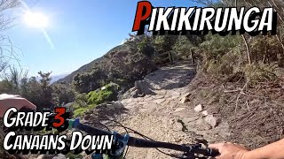
The Takaka Hill is an iconic road in the South Island of New Zealand. State Highway 60 reaches 791 meters above sea level. For local mountain bikers it has always been the Holy Grail, to create a mountain bike ride from the top of this famous New Zealand hill, all the way to the bottom on the Takaka valley side. The potential is huge. The concept is to realize that dream and create a truly iconic classic mountain bike experience that every mountain biker in New Zealand will need to ride. As the descent is 650 meters over some 8km we will build the track in three stages that join together to descend the whole hill. This approach will allow us to more effectively manage this large project, we can build and open each stage whilst we are planning for the next one. The Pikikirunga track will be a grade 3, descending, all-weather mountain bike single track that will allow a greater number of abilities to enjoy this epic 8 km descent.
Stage One: A 3km section running Northwest from the Takaka Hill Saddle (Golden Bay side) and finishing 300m west of the highway. The route passes through the Takaka Hill Scenic Reserve for its whole length. The reserve is managed by the Department of Conservation. The Golden Bay Mountain Bike Club has been granted permission to build the track by the Department of Conservation and signed a community agreement to that effect on 15th December 2020.

Trail Supporters
Local Trail Association

Recent Activity on Trail

Past Week
  • 0 rides
  •  
6 Months
  • 2 rides
  • 8 miles avg distance
All
  • 13 rides
  • Last: Mar 4, 2026
c1c2c3c4
January
February
March
April
May
June
July
August
September
October
November
December
update trails status or condition

Pikikirunga Trail Trail Reports

statusdatedescription
Jul 7, 2025 @ 10:17pm
Jul 7, 2025
A few tree fallen across the trail
Apr 14, 2025 @ 2:40pm
Apr 14, 2025
more »
Status:
on Jul 7, 2025
Wet
Avg: 5 (1 votes)
Your vote: 0

view (40)
close
3D
Trail Conditions
  • Unknown
  • Snow Groomed
  • Snow Packed
  • Snow Covered
  • Snow Cover Partial
  • Freeze/thaw Cycle
  • Icy
  • Prevalent Mud
  • Wet
  • Variable
  • Ideal
  • Dry
  • Very Dry
Trail Flow (Ridden Direction)
Trailforks scans users ridelogs to determine the most popular direction each trail is ridden. A good flowing trail network will have most trails flowing in a single direction according to their intension.
The colour categories are based on what percentage of riders are riding a trail in its intended direction.
  • > 96%
  • > 90%
  • > 80%
  • > 70%
  • > 50%
  • < 50%
  • bi-directional trail
  • no data
Trail Last Ridden
Trailforks scans ridelogs to determine the last time a trail was ridden.
  • < 2 days
  • < 1 week
  • < 2 weeks
  • < 1 month
  • < 6 months
  • > 6 months
Trail Ridden Direction
The intended direction a trail should be ridden.
  • Downhill Only
  • Downhill Primary
  • Both Directions
  • Uphill Primary
  • Uphill Only
  • One Direction
Contribute Details
Colors indicate trail is missing specified detail.
  • Description
  • Photos
  • Description & Photos
  • Videos
Trail Popularity ?
Trailforks scans ridelogs to determine which trails are ridden the most in the last 9 months. Trails are compared with nearby trails in the same city region with a possible 25 colour shades. Think of this as a heatmap, more rides = more kinetic energy = warmer colors.
  • most popular
  • popular
  • less popular
  • not popular
ATV/ORV/OHV Filter
Max Vehicle Width
inches
US Cell Coverage
Legend
cell carrier legend

Radar Time
Activity Recordings
Trailforks uses anonymized public activity data. ?
Activity Recordings
Trailforks uses anonymized public activity data. ?
Personal Heatmap
Activity Types
all / none
Options
2
Date range month
Winter Trails
Warning A routing network for winter maps does not exist. Selecting trails using the winter trails layer has been disabled.
Missing Trails
Most Popular
Least Popular
Trails are colored based on popularity. The more popular a trail is, the more red. Less popular trails trend towards green.
Jump Magnitude Heatmap
Heatmap of where riders jump on trails. Zoom in to see individual jumps, click circles to view jump details.
BC Backroad Status

Service Road Atlas is a free to use, community-driven service for viewing and creating reports on the numerous back-country service roads around B.C. and Alberta.

map legend
Slope Aspect
Direction the slope faces
Flat N NE E SE S SW W NW
Trails Deemphasized
Trails are shown in grey.
disable
Only show trails with no bike usage.
Enable
Suggested Layers
Based on selected activity type

    Save the current map location and zoom level as your default home location whenever this page is loaded.

    Save
        Directions to pikikirunga-trail trailhead (-41.030820, 172.866760)

        Photos

        No photos have been added for Pikikirunga Trail yet, add a photo.

        Videos

        2 more »
        Newest downhill on Takaka Hill - Pikikirunga Trail
        11:55 | 161 | May 16, 2025 , Takaka
        Riding Pikikirunga trail-Takaka hill
        10:03 | 63 | Jul 13, 2025 , Takaka

        1 Review & Comments


        We hope you've been enjoying Trailforks!

        Create a FREE account to view trail comments and much more.

        • By NZMTBRallyTF Pro & contributors
        • #827559 - 1,236 views

        Frequently Asked Questions About Pikikirunga Trail

        Where is Pikikirunga Trail located?
        Pikikirunga Trail is located in Canaan Downs, Takaka, New Zealand. It is part of the Canaan Downs trail network. The trailhead is located at coordinates -41.03082, 172.86676.
        How hard is Pikikirunga Trail?
        Pikikirunga Trail is rated as Blue difficulty. The average grade is 6.1%.
        What is the elevation gain for Pikikirunga Trail?
        Pikikirunga Trail has 203 ft of elevation gain. The trail has 907 ft of elevation descent. The elevation ranges from 1,905 ft to 2,706 ft.
        Is Pikikirunga Trail a point to point trail?
        Pikikirunga Trail is not a point to point trail. The direction is Downhill Primary. The trail type is singletrack.

        Hit the Trail

        Open in App

        Get this trail on your phone instantly.
        open trail in app

        Download Trail

        Save to wishlist, Garmin & download.
        save the trail

        Find Related Routes

        Find routes and users activities that include this trail.
        find routes for this trail

        You must enter a description before submitting.