more stats
1,424 ft
Distance
-242 ft
Descent
00:03:17
Avg time
-242 ft
Altitude change
2,174 ft
Altitude min
2,416 ft
Altitude max
2,416 ft
Altitude start
2,175 ft
Altitude end
-17%
Grade
-52.1%
Grade max
-2.6%
Grade min
1,424 ft
Distance down
00:03:17
Avg time

Pile of Rocks Details

  • Activities
    • Mountain Bike
    • E-Bike
    • Hike
    • Trail Running
  • Riding Area
    Mount Fromme
    North Vancouver, British Columbia
  • Difficulty Rating
  • Voted Difficulty
    Blue (10 votes)
  • Local Popularity
    75 in Mountain Biking [+]
    • 80 in E-Biking
    • 25 in Trail Running
    • 50 in Hiking
  • Global Ranking
    #21947 in Mountain Biking [+]
    • #2004 in E-Biking
    • #72361 in Trail Running
    • #22685 in Hiking
  • Trail Type
    Singletrack
  • Bike Type
    DH
  • Direction
    Downhill Primary
    Popular Direction Shown
  • Dogs Allowed
    Yes
  • eBike Allowed
  • Land Owner
    Grouse Mountain

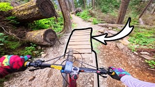
Old skidder road that is rooty and naturally technical, with many small drops and tight turns. Roots can be slippery in the wet. It makes a good link-up with Executioner or Lower Oilcan in terms of difficulty, and location.

Access Info

Accessed off Moutain Hwy just past the 6th switchback, exits back on Mountain Hwy.

Trail Supporters
  • Oscar N.
    Builder
Local Trail Association

Recent Activity on Trail

Past Week
  • 6 rides
  • 7 miles average
6 Months
  • 79 rides
  • 9 miles avg distance
All
  • 1,287 rides
  • Last: Jun 18, 2026
c1c2c3c4
January
February
March
April
May
June
July
August
September
October
November
December
update trails status or condition

Pile of Rocks Trail Reports

Status:
on May 2, 2026
Ideal
Avg: 3.37 (42 votes)
Your vote: 0

view (6,832)
close
3D
Trail Conditions
  • Unknown
  • Snow Groomed
  • Snow Packed
  • Snow Covered
  • Snow Cover Partial
  • Freeze/thaw Cycle
  • Icy
  • Prevalent Mud
  • Wet
  • Variable
  • Ideal
  • Dry
  • Very Dry
Trail Flow (Ridden Direction)
Trailforks scans users ridelogs to determine the most popular direction each trail is ridden. A good flowing trail network will have most trails flowing in a single direction according to their intension.
The colour categories are based on what percentage of riders are riding a trail in its intended direction.
  • > 96%
  • > 90%
  • > 80%
  • > 70%
  • > 50%
  • < 50%
  • bi-directional trail
  • no data
Trail Last Ridden
Trailforks scans ridelogs to determine the last time a trail was ridden.
  • < 2 days
  • < 1 week
  • < 2 weeks
  • < 1 month
  • < 6 months
  • > 6 months
Trail Ridden Direction
The intended direction a trail should be ridden.
  • Downhill Only
  • Downhill Primary
  • Both Directions
  • Uphill Primary
  • Uphill Only
  • One Direction
Contribute Details
Colors indicate trail is missing specified detail.
  • Description
  • Photos
  • Description & Photos
  • Videos
Trail Popularity ?
Trailforks scans ridelogs to determine which trails are ridden the most in the last 9 months. Trails are compared with nearby trails in the same city region with a possible 25 colour shades. Think of this as a heatmap, more rides = more kinetic energy = warmer colors.
  • most popular
  • popular
  • less popular
  • not popular
ATV/ORV/OHV Filter
Max Vehicle Width
inches
US Cell Coverage
Legend
cell carrier legend

Radar Time
Activity Recordings
Trailforks uses anonymized public activity data. ?
Activity Recordings
Trailforks uses anonymized public activity data. ?
Personal Heatmap
Activity Types
all / none
Options
2
Date range month
Winter Trails
Warning A routing network for winter maps does not exist. Selecting trails using the winter trails layer has been disabled.
Missing Trails
Most Popular
Least Popular
Trails are colored based on popularity. The more popular a trail is, the more red. Less popular trails trend towards green.
Jump Magnitude Heatmap
Heatmap of where riders jump on trails. Zoom in to see individual jumps, click circles to view jump details.
BC Backroad Status

Service Road Atlas is a free to use, community-driven service for viewing and creating reports on the numerous back-country service roads around B.C. and Alberta.

map legend
Slope Aspect
Direction the slope faces
Flat N NE E SE S SW W NW
Trails Deemphasized
Trails are shown in grey.
disable
Only show trails with no bike usage.
Enable
Suggested Layers
Based on selected activity type

    Save the current map location and zoom level as your default home location whenever this page is loaded.

    Save
        Directions to pile-rocks trailhead (49.361040, -123.062790)

        Photos

        57 more »
        162 |
        Nov 22, 2023 @ 8:16pm
        Nov 22, 2023
        371 |
        Jan 21, 2022 @ 11:46am
        Jan 21, 2022
        192 |
        Jan 21, 2022 @ 9:22am
        Jan 21, 2022
        211 |
        Jan 21, 2022 @ 9:26am
        Jan 21, 2022

        Videos

        15 more »
        youtuber This Race Nearly Broke Me
        18:37 | 127 | Jun 14, 2025 , North Vancouver
        youtuber Pile Of Rocks - Fromme Mountain Biking
        0:49 | 884 | Aug 5, 2021 , North Vancouver
        Pile of Rocks, Mt. Fromme | ROOTS & ROCKS...
        0:59 | 27 | Nov 29, 2025 , North Vancouver
        ROOTS & ROCKS GALORE! Pile of Rocks on Mt....
        0:59 | 35 | Nov 4, 2025 , North Vancouver

        Trail Lists

        Routes with this trail

        45 miles 12,232 ft 155 Loop
        For crazy people that want to attempt riding all the trails on Fromme! 41 unique trails covered in this...
        32 miles 8,493 ft 60
        Mount Fromme Epic. Line up all trails off of ! This all day adventure for those looking for a challenge!...
        32 miles 8,300 ft 60
        Mount Fromme Epic. Line up all trails off of ! This all day adventure for those looking for a challenge!...

        21 Reviews & Comments


        We hope you've been enjoying Trailforks!

        Create a FREE account to view trail comments and much more.

        • By canadakaTF Pro Trailforks & contributors
        • #168 - 14,699 views

        Frequently Asked Questions About Pile of Rocks

        Where is Pile of Rocks located?
        Pile of Rocks is located in Mount Fromme, North Vancouver, British Columbia, Canada. It is part of the Mount Fromme trail network. The trailhead is located at coordinates 49.36104, -123.06279.
        How hard is Pile of Rocks?
        Pile of Rocks is rated as Black Diamond difficulty. The average grade is 17%.
        What is the elevation gain for Pile of Rocks?
        The trail has 242 ft of elevation descent. The elevation ranges from 2,174 ft to 2,416 ft.
        Is Pile of Rocks a point to point trail?
        Pile of Rocks is not a point to point trail. The direction is Downhill Primary. The trail type is singletrack.

        Hit the Trail

        Open in App

        Get this trail on your phone instantly.
        open trail in app

        Download Trail

        Save to wishlist, Garmin & download.
        save the trail

        Find Related Routes

        Find routes and users activities that include this trail.
        find routes for this trail

        You must enter a description before submitting.