more stats
1,959 ft
Distance
-213 ft
Descent
00:01:28
Avg time
-213 ft
Altitude change
8,909 ft
Altitude min
9,122 ft
Altitude max
9,122 ft
Altitude start
8,911 ft
Altitude end
-10.9%
Grade
-32.4%
Grade max
-3.4%
Grade min
1,959 ft
Distance down
00:01:28
Avg time

Pinball Details

  • Activities
    • Mountain Bike
    • E-Bike
  • Riding Area
    Angel Fire Bike Park
    Angel Fire, New Mexico
  • Difficulty Rating
  • Voted Difficulty
    Black Diamond (1 vote)
  • Local Popularity
    95 in Mountain Biking
  • Global Ranking
    #43871 in Mountain Biking
  • Trail Type
    Machine Groomed
  • Bike Type
    DH, AM
  • Direction
    Downhill Only
    Popular Direction Shown
  • Physical Rating
    Hard
  • Trail Visibility
    Always easy to follow
  • eBike Allowed
  • TTFs on Trail
    Berm, Bridge, Drop, Jump, Gap Jump
  • Land Owner
    Angel Fire Resort

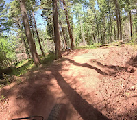
Pinball starts with a step-up, which if you clear (you will need all your speed and then some), will take your momentum into the rest of the trail. Narrow and flowy at the top, with a couple of root drops, this trail quickly becomes steep and bermy with a gap jump and a big step up under the chairlift. It finishes off with an optional ramp drop (about 4 to 6 feet depending how far you send it). This is an easier black, but tricky to ride clean and fast.

Disclaimer

Pinball is scheduled to be worked on this summer so pre-ride, re-ride, free-ride

Bike Park

Recent Activity on Trail

Past Week
  • 17 rides
  • 37 miles average
6 Months
  • 94 rides
  • 31 miles avg distance
All
  • 1,049 rides
  • Last: Jun 20, 2026
c1c2c3c4
January
February
March
April
May
June
July
August
September
October
November
December
update trails status or condition

Pinball Trail Reports

Status:
on May 29, 2026
Ideal
Avg: 3.83 (6 votes)
Your vote: 0

view (12,727)
close
3D
Trail Conditions
  • Unknown
  • Snow Groomed
  • Snow Packed
  • Snow Covered
  • Snow Cover Partial
  • Freeze/thaw Cycle
  • Icy
  • Prevalent Mud
  • Wet
  • Variable
  • Ideal
  • Dry
  • Very Dry
Trail Flow (Ridden Direction)
Trailforks scans users ridelogs to determine the most popular direction each trail is ridden. A good flowing trail network will have most trails flowing in a single direction according to their intension.
The colour categories are based on what percentage of riders are riding a trail in its intended direction.
  • > 96%
  • > 90%
  • > 80%
  • > 70%
  • > 50%
  • < 50%
  • bi-directional trail
  • no data
Trail Last Ridden
Trailforks scans ridelogs to determine the last time a trail was ridden.
  • < 2 days
  • < 1 week
  • < 2 weeks
  • < 1 month
  • < 6 months
  • > 6 months
Trail Ridden Direction
The intended direction a trail should be ridden.
  • Downhill Only
  • Downhill Primary
  • Both Directions
  • Uphill Primary
  • Uphill Only
  • One Direction
Contribute Details
Colors indicate trail is missing specified detail.
  • Description
  • Photos
  • Description & Photos
  • Videos
Trail Popularity ?
Trailforks scans ridelogs to determine which trails are ridden the most in the last 9 months. Trails are compared with nearby trails in the same city region with a possible 25 colour shades. Think of this as a heatmap, more rides = more kinetic energy = warmer colors.
  • most popular
  • popular
  • less popular
  • not popular
ATV/ORV/OHV Filter
Max Vehicle Width
inches
US Cell Coverage
Legend
cell carrier legend

Radar Time
Activity Recordings
Trailforks uses anonymized public activity data. ?
Activity Recordings
Trailforks uses anonymized public activity data. ?
Personal Heatmap
Activity Types
all / none
Options
2
Date range month
Winter Trails
Warning A routing network for winter maps does not exist. Selecting trails using the winter trails layer has been disabled.
Missing Trails
Most Popular
Least Popular
Trails are colored based on popularity. The more popular a trail is, the more red. Less popular trails trend towards green.
Jump Magnitude Heatmap
Heatmap of where riders jump on trails. Zoom in to see individual jumps, click circles to view jump details.
BC Backroad Status

Service Road Atlas is a free to use, community-driven service for viewing and creating reports on the numerous back-country service roads around B.C. and Alberta.

map legend
Slope Aspect
Direction the slope faces
Flat N NE E SE S SW W NW
Trails Deemphasized
Trails are shown in grey.
disable
Only show trails with no bike usage.
Enable
Suggested Layers
Based on selected activity type

    Save the current map location and zoom level as your default home location whenever this page is loaded.

    Save
        Directions to pinball-69286 trailhead (36.383240, -105.259550)

        Photos

        1 more »
        209 |
        Nov 15, 2008 @ 9:15am
        Nov 15, 2008

        Videos

        2 more »
        Pinball - Jazz Hands -- Angel Fire Bike Park, NM
        2:36 | 115 | Oct 10, 2023 , Angel Fire
        Angel Fire Crash
        0:18 | 30 | Jun 14, 2025 , Angel Fire

        Reviews / Comments

        No reviews yet, be the first to write a review or ask a question.
        Use trail reports to comment on trail conditions.


        We hope you've been enjoying Trailforks!

        Create a FREE account to view trail comments and much more.

        • By toddTF Pro Trailforks & contributors
        • #69286 - 1,705 views

        Frequently Asked Questions About Pinball

        Where is Pinball located?
        Pinball is located in Angel Fire Bike Park, Angel Fire, New Mexico, United States. It is part of the Angel Fire Bike Park trail network. The trailhead is located at coordinates 36.38324, -105.25955.
        How hard is Pinball?
        Pinball is rated as Black Diamond difficulty. The physical rating is Hard. The average grade is 10.9%.
        What is the elevation gain for Pinball?
        The trail has 213 ft of elevation descent. The elevation ranges from 8,909 ft to 9,122 ft.
        Is Pinball a point to point trail?
        Yes, Pinball is a point to point trail. The direction is Downhill Only. The trail type is machine groomed.

        Hit the Trail

        Open in App

        Get this trail on your phone instantly.
        open trail in app

        Download Trail

        Save to wishlist, Garmin & download.
        save the trail

        Find Related Routes

        Find routes and users activities that include this trail.
        find routes for this trail

        You must enter a description before submitting.