
Open in App
Get this trail on your phone instantly.

This trail connects the Friends’ Loop to the Charge Pond Loop along the eastern side of the forest. You can also access the trail from the fourth parking pull-off on Cutter Field Road. This path will take you through the globally rare Pine Barrens habitats and past various frost pockets. Look for the Buck Moth, a black, white, and orange species that flies during the day like a butterfly, and birds like the Rufous-sided Towhee and the Pine Warbler.
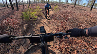
This eight mile trail runs up the eastern side of the forest. Much of the trail passes through classic pine barrens. It also passes through some tall white pine forests and some areas that were logged in 2015 because of the red pine scale (close to Priscilla Road).
The trail surface is mostly smooth and flowing on solid hard-pack, with intermittent modest sand, roots, rocks and rough. The trail is fairly flat with moderate elevation changes.
The trail is suitable for hikers of all abilities as well as confident novice mountain bikers and above.
The entire eight miles of the trail from its northern end along the Friends Trail to its southern end at Sasemine Road (off Charge Pond Road) was blazed with blue painted trail markings in 2016 and wooden trail signs were placed along the trail.
Typically, we walk the trail from south to north after leaving a car at the park's Long Pond Road entrance parking lot. Then, driving south along Upper College Pond Road towards Charge Pond, we park at the parking lot along Charge Pond Road. Starting from the bike trail parking lot, we walk a short distance north along Charge Pond Road, and we head east on the dirt Sasemine Road until we find the Pine Barrens Path trail head. (Note: the campground road is closed at the gate from Fearing Pond Road after camping season. Park at the gate and walk in along the road.)
Several miles can be cut from the trail by parking in the fourth parking lot along Cuttersfield Road (easiest way to get there is to follow the signs to Camp Squanto- the trail head is in the fourth parking lot along Cuttersfield Road, the first after the big curve). From Cuttersfield Road, the trail heads north through the wide open fields (the Cutter fields) for about two-thirds of a mile until it hits Webster Springs Road. Then it heads west (left) along Webster Springs Road for about one half of a mile, until it makes a right turn at the trail sign into the forest and heads north.
16 additional trail signs were produced by the DCR in 2016 to make locating the trail heads easier and installation along the Pine Barrens Path is complete. A connection from the Friends Trail is evident on the new map and the entrance has been marked with a sign.
| c1 | c2 | c3 | c4 |
|---|---|---|---|
January | February | March | April |
May | June | July | August |
September | October | November | December |

Service Road Atlas is a free to use, community-driven service for viewing and creating reports on the numerous back-country service roads around B.C. and Alberta.
Save the current map location and zoom level as your default home location whenever this page is loaded.
SaveWe hope you've been enjoying Trailforks!
Create a FREE account to view trail comments and much more.
You must enter a description before submitting.

