This trail is permanently closed/decommissioned
more stats
3,148 ft
Distance
-633 ft
Descent
00:13:15
Avg time
-633 ft
Altitude change
1,562 ft
Altitude min
2,195 ft
Altitude max
2,195 ft
Altitude start
1,562 ft
Altitude end
-20.114%
Grade
-61.419%
Grade max
-1.147%
Grade min
3,106 ft
Distance down
42 ft
Distance flat
00:13:15
Avg time

Pink Starfish Details

  • Activities
    • Mountain Bike
    • Hike
    • Trail Running
  • Riding Area
    Mount Fromme
    North Vancouver, British Columbia
  • Difficulty Rating
  • Voted Difficulty
    Proline (2 votes)
  • Local Popularity
    15 in Mountain Biking [+]
    • 5 in Trail Running
    • 35 in Hiking
  • Trail Type
    Singletrack
  • Bike Type
    DH
  • Direction
    Downhill Primary
    Popular Direction Shown
  • Dogs Allowed
    Yes
  • TTFs on Trail
    Drop, Jump, Skinny
  • Land Owner
    Grouse (first 30m distance) & DNV

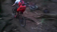
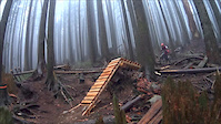
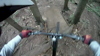
Contains mandatory jumps with ride-arounds. Classic whiplash inducing drop to flat terrain. Not for beginner riders.

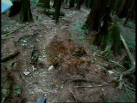
Some history: Starfish was built by Dave Moody in the mid 90s. It was built with all the skinnies, features and the Ogopogo log in super creative fashion by Dave through the North Shore Pathways Society.

Access Info

Acessed off Mountain Hwy exiting on the Baden Powell at Abelard Canyon.

Disclaimer

marking trail as closed

Recent Activity on Trail

Past Week
  • 0 rides
  •  
6 Months
  • 1 rides
  • 6 miles avg distance
All
  • 26 rides
  • Last: Feb 23, 2026
c1c2c3c4
January
February
March
April
May
June
July
August
September
October
November
December
update trails status or condition

Pink Starfish Trail Reports

statusdatedescription
Oct 5, 2019 @ 5:17pm
Oct 5, 2019
Nov 23, 2016 @ 10:00am
Nov 23, 2016
Notice from District of North Vancouver, Tuesday, Nov 22, 2016 http://bit.ly/2frSsoT Pink Starfish Trail on Fromme Mountain has been...
Aug 2, 2016 @ 3:04pm
Aug 2, 2016
26/07/2016 – Pink Starfish Update ointly, the District of North Vancouver (DNV) and the North Shore Mountain Bike Association (NSMBA) would...
Aug 1, 2016 @ 12:07pm
Aug 1, 2016
Trail is still open and rideable. Some of the new woodwork that was decommissioned is on the trail itself so you'll have to walk around it. ...
Jul 23, 2016 @ 10:16am
Jul 23, 2016
Decommissioned/Closed by DNV Parks
more »
Status:
on Oct 5, 2019
Avg: 4.05 (13 votes)
Your vote: 0

view (141)
close
3D
Trail Conditions
  • Unknown
  • Snow Groomed
  • Snow Packed
  • Snow Covered
  • Snow Cover Partial
  • Freeze/thaw Cycle
  • Icy
  • Prevalent Mud
  • Wet
  • Variable
  • Ideal
  • Dry
  • Very Dry
Trail Flow (Ridden Direction)
Trailforks scans users ridelogs to determine the most popular direction each trail is ridden. A good flowing trail network will have most trails flowing in a single direction according to their intension.
The colour categories are based on what percentage of riders are riding a trail in its intended direction.
  • > 96%
  • > 90%
  • > 80%
  • > 70%
  • > 50%
  • < 50%
  • bi-directional trail
  • no data
Trail Last Ridden
Trailforks scans ridelogs to determine the last time a trail was ridden.
  • < 2 days
  • < 1 week
  • < 2 weeks
  • < 1 month
  • < 6 months
  • > 6 months
Trail Ridden Direction
The intended direction a trail should be ridden.
  • Downhill Only
  • Downhill Primary
  • Both Directions
  • Uphill Primary
  • Uphill Only
  • One Direction
Contribute Details
Colors indicate trail is missing specified detail.
  • Description
  • Photos
  • Description & Photos
  • Videos
Trail Popularity ?
Trailforks scans ridelogs to determine which trails are ridden the most in the last 9 months. Trails are compared with nearby trails in the same city region with a possible 25 colour shades. Think of this as a heatmap, more rides = more kinetic energy = warmer colors.
  • most popular
  • popular
  • less popular
  • not popular
ATV/ORV/OHV Filter
Max Vehicle Width
inches
US Cell Coverage
Legend
cell carrier legend

Radar Time
Activity Recordings
Trailforks uses anonymized public activity data. ?
Activity Recordings
Trailforks uses anonymized public activity data. ?
Personal Heatmap
Activity Types
all / none
Options
2
Date range month
Winter Trails
Warning A routing network for winter maps does not exist. Selecting trails using the winter trails layer has been disabled.
Missing Trails
Most Popular
Least Popular
Trails are colored based on popularity. The more popular a trail is, the more red. Less popular trails trend towards green.
Jump Magnitude Heatmap
Heatmap of where riders jump on trails. Zoom in to see individual jumps, click circles to view jump details.
BC Backroad Status

Service Road Atlas is a free to use, community-driven service for viewing and creating reports on the numerous back-country service roads around B.C. and Alberta.

map legend
Slope Aspect
Direction the slope faces
Flat N NE E SE S SW W NW
Trails Deemphasized
Trails are shown in grey.
disable
Only show trails with no bike usage.
Enable
Suggested Layers
Based on selected activity type

    Save the current map location and zoom level as your default home location whenever this page is loaded.

    Save
        Directions to pink-starfish trailhead (49.358400, -123.062340)

        Photos

        78 more »
        1,856 |
        Jun 20, 2014 @ 10:03am
        Jun 20, 2014
        73 |
        Jun 6, 2024 @ 10:09am
        Jun 6, 2024
        116 |
        Jun 6, 2024 @ 10:09am
        Jun 6, 2024
        285 |
        Oct 30, 2022 @ 6:52pm
        Oct 30, 2022

        Videos

        7 more »
        Pink Starfish 2009
        8:31 | 1577 | Sep 19, 2011 , North Vancouver
        New Pink Starfish Wood TTF Jump
        0:25 | 789 | Jun 10, 2016 , North Vancouver
        PS and Dreamweaver
        0:13 | 1168 | May 27, 2016 , North Vancouver
        Free
        3:06 | 1667 | May 22, 2016 , North Vancouver

        Routes with this trail

        12 miles 3,541 ft 34 Loop

        9 Reviews & Comments


        We hope you've been enjoying Trailforks!

        Create a FREE account to view trail comments and much more.

        • By canadakaTF Pro Trailforks & contributors
        • #158 - 19,652 views

        Frequently Asked Questions About Pink Starfish

        Where is Pink Starfish located?
        Pink Starfish is located in Mount Fromme, North Vancouver, British Columbia, Canada. It is part of the Mount Fromme trail network. The trailhead is located at coordinates 49.3584, -123.06234.
        How hard is Pink Starfish?
        Pink Starfish is rated as Double Black Diamond difficulty. The average grade is 20.114%.
        What is the elevation gain for Pink Starfish?
        The trail has 633 ft of elevation descent. The elevation ranges from 1,562 ft to 2,195 ft.
        Is Pink Starfish a point to point trail?
        Pink Starfish is not a point to point trail. The direction is Downhill Primary. The trail type is singletrack.

        Hit the Trail

        Open in App

        Get this trail on your phone instantly.
        open trail in app

        Download Trail

        Save to wishlist, Garmin & download.
        save the trail

        Find Related Routes

        Find routes and users activities that include this trail.
        find routes for this trail

        You must enter a description before submitting.