more stats
4.5 miles
Distance
454 ft
Climb
-487 ft
Descent
01:15:57
Avg time
-35 ft
Altitude change
618 ft
Altitude min
923 ft
Altitude max
653 ft
Altitude start
617 ft
Altitude end
-0.1%
Grade
-20.6%
Grade max
20.5%
Grade min
2 miles
Distance climb
2 miles
Distance down
3,517 ft
Distance flat
01:15:57
Avg time

Pionéren Details

  • Activities
    • Mountain Bike
    • Hike
    • Trail Running
  • Riding Area
  • Difficulty Rating
  • Local Popularity
    80 in Mountain Biking [+]
    • 5 in Trail Running
    • 5 in Hiking
  • Global Ranking
    #55514 in Mountain Biking [+]
    • #127242 in Trail Running
    • #120447 in Hiking
  • Hiking SAC Scale
    T1 Hiking
  • Trail Type
    Singletrack
  • Bike Type
    AM
  • Climb Difficulty
    Blue
  • Physical Rating
    Hard
  • Season
    From May to end of October
  • Family Friendly
    Yes
  • Dogs Allowed
    Yes
  • TTFs on Trail
    Berm, Bridge, Drop, Jump, Log Ride, Rock Garden
  • Ride in Rain
    Yes
  • Year Opened
    2018
  • Land Owner
    NOTS, and Bymiljøetaten

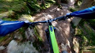
A fantastic trail created for MTB enthusiasts.

Norsk/Norwegian
En fantastisk sti laget for MTB-entusiaster.

Access Info

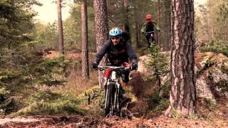
You can take metro No. 3 towards Mortensrud to Skullerud, or bus 76 or 79 to Welding Olsens Vei, and ride up to Rustadsaga or down to Skullerudstua.

Norsk/Norwegian
Du kan ta metro nr. 3 mot Mortensrud til Skullerud, eller buss 76 eller 79 til Welding Olsens Vei, og sykle opp til Rustadsaga eller ned til Skullerudstua.

Local Trail Association

Recent Activity on Trail

Past Week
  • 0 rides
  •  
6 Months
  • 2 rides
  • 14 miles avg distance
All
  • 29 rides
  • Last: Nov 8, 2015
c1c2c3c4
January
February
March
April
May
June
July
August
September
October
November
December
update trails status or condition

Pionéren Trail Reports

statusdatedescription
Aug 26, 2025 @ 1:57am
Aug 26, 2025
Aug 22, 2025 @ 3:21am
Aug 22, 2025
Oct 7, 2023 @ 5:31am
Oct 7, 2023
Broken bridge
Aug 27, 2023 @ 3:19am
Aug 27, 2023
the wooden bridge at the south bend is destroyed, some places pretty muddy but most of them well rideable
Jul 17, 2023 @ 9:46pm
Jul 17, 2023
more »
Status:
on Aug 26, 2025
Ideal
Avg: 3.39 (4 votes)
Your vote: 0

view (300)
close
3D
Trail Conditions
  • Unknown
  • Snow Groomed
  • Snow Packed
  • Snow Covered
  • Snow Cover Partial
  • Freeze/thaw Cycle
  • Icy
  • Prevalent Mud
  • Wet
  • Variable
  • Ideal
  • Dry
  • Very Dry
Trail Flow (Ridden Direction)
Trailforks scans users ridelogs to determine the most popular direction each trail is ridden. A good flowing trail network will have most trails flowing in a single direction according to their intension.
The colour categories are based on what percentage of riders are riding a trail in its intended direction.
  • > 96%
  • > 90%
  • > 80%
  • > 70%
  • > 50%
  • < 50%
  • bi-directional trail
  • no data
Trail Last Ridden
Trailforks scans ridelogs to determine the last time a trail was ridden.
  • < 2 days
  • < 1 week
  • < 2 weeks
  • < 1 month
  • < 6 months
  • > 6 months
Trail Ridden Direction
The intended direction a trail should be ridden.
  • Downhill Only
  • Downhill Primary
  • Both Directions
  • Uphill Primary
  • Uphill Only
  • One Direction
Contribute Details
Colors indicate trail is missing specified detail.
  • Description
  • Photos
  • Description & Photos
  • Videos
Trail Popularity ?
Trailforks scans ridelogs to determine which trails are ridden the most in the last 9 months. Trails are compared with nearby trails in the same city region with a possible 25 colour shades. Think of this as a heatmap, more rides = more kinetic energy = warmer colors.
  • most popular
  • popular
  • less popular
  • not popular
ATV/ORV/OHV Filter
Max Vehicle Width
inches
US Cell Coverage
Legend
cell carrier legend

Radar Time
Activity Recordings
Trailforks uses anonymized public activity data. ?
Activity Recordings
Trailforks uses anonymized public activity data. ?
Personal Heatmap
Activity Types
all / none
Options
2
Date range month
Winter Trails
Warning A routing network for winter maps does not exist. Selecting trails using the winter trails layer has been disabled.
Missing Trails
Most Popular
Least Popular
Trails are colored based on popularity. The more popular a trail is, the more red. Less popular trails trend towards green.
Jump Magnitude Heatmap
Heatmap of where riders jump on trails. Zoom in to see individual jumps, click circles to view jump details.
BC Backroad Status

Service Road Atlas is a free to use, community-driven service for viewing and creating reports on the numerous back-country service roads around B.C. and Alberta.

map legend
Slope Aspect
Direction the slope faces
Flat N NE E SE S SW W NW
Trails Deemphasized
Trails are shown in grey.
disable
Only show trails with no bike usage.
Enable
Suggested Layers
Based on selected activity type

    Save the current map location and zoom level as your default home location whenever this page is loaded.

    Save
        Directions to pioneren trailhead (59.871600, 10.866140)

        Photos

        1 more »
        81 |
        Oct 7, 2023 @ 5:31am
        Oct 7, 2023

        Videos

        6 more »
        Emtb Oslo Pioneren
        14:35 | 503 | May 25, 2021 , Oslo
        Pioneren 1. Mai 2016
        0:55 | 519 | Jun 11, 2018 , Oslo
        Dobbelttest: NOTS Pioneren med ny tjukksykkel....
        0:05 | 454 | Jun 11, 2018 , Oslo
        Åpning av NOTS' stiprosjekt Pionéren /...
        3:00 | 353 | Jun 11, 2018 , Oslo

        1 Review & Comments


        We hope you've been enjoying Trailforks!

        Create a FREE account to view trail comments and much more.

        • By AdrianCzina & contributors
        • #133922 - 4,189 views

        Frequently Asked Questions About Pionéren

        Where is Pionéren located?
        Pionéren is located in Østmarka Vest, Oslo, Norway. It is part of the Østmarka Vest trail network. The trailhead is located at coordinates 59.8716, 10.86614.
        How hard is Pionéren?
        Pionéren is rated as Blue difficulty. The physical rating is Hard. The average grade is 0.1%. The climb difficulty is rated Blue.
        What is the elevation gain for Pionéren?
        Pionéren has 138 m of elevation gain. The trail has 148 m of elevation descent. The elevation ranges from 188 m to 281 m.
        How long is Pionéren?
        Pionéren is 7.2 km long. The trail type is singletrack.

        Hit the Trail

        Open in App

        Get this trail on your phone instantly.
        open trail in app

        Download Trail

        Save to wishlist, Garmin & download.
        save the trail

        Find Related Routes

        Find routes and users activities that include this trail.
        find routes for this trail

        You must enter a description before submitting.