more stats
4.5 miles
Distance
137 ft
Climb
-2,980 ft
Descent
01:28:05
Avg time
-2,843 ft
Altitude change
5,300 ft
Altitude min
8,143 ft
Altitude max
8,143 ft
Altitude start
5,302 ft
Altitude end
-11.9%
Grade
-82.5%
Grade max
20.2%
Grade min
2,484 ft
Distance climb
4 miles
Distance down
1,362 ft
Distance flat
01:28:05
Avg time

Pischa Details

  • Activities
    • Mountain Bike
    • E-Bike
    • Hike
    • Trail Running
  • Riding Area
  • Ref Number
    #645
  • Difficulty Rating
  • Voted Difficulty
    Secondary Access Road/Trail (5 votes)
  • Local Popularity
    75 in Mountain Biking [+]
    • 85 in E-Biking
    • 5 in Trail Running
    • 55 in Hiking
  • Global Ranking
    #24847 in Mountain Biking [+]
    • #21 in E-Biking
    • #125622 in Trail Running
    • #50672 in Hiking
  • Hiking SAC Scale
    T1 Hiking
  • Trail Type
    Singletrack
  • Bike Type
    AM, XC
  • Climb Difficulty
    Black Diamond
  • Physical Rating
    Hard
  • Trail Visibility
    Always easy to follow
  • Season
    Juni - Oktober
  • Alpine Trail
    Yes
  • Dogs Allowed
    Yes
  • eBike Allowed
    Yes up to Class 1
  • TTFs on Trail
    Rock Face, Rock Garden
  • Land Owner

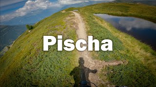
Anspruchsvolle Singletrail-Tour hoch über dem Flüelatal mit grandioser Aussicht. Direkt bei der kleinen Kirche auf Tschuggen steigt der Trail stark an und es folgen anstrengende Höhenmeter. Kurz vor der Bergstation geht der Trail in eine Fahrstrasse über und die Steigung wird angenehmer.
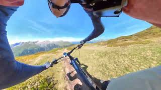
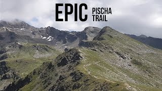
Von der Bergstation (nur im Winter in Betrieb) führt ein kniffliger, aber spassiger Singletrail den Grat entlang und bietet eine grandiose Aussicht auf die umliegende Bergwelt. Vor der letzten Steigung auf das Hüreli zweigt der Trail rechts ab und führt in wunderschönem Flow über Bergwiesen Richtung Drusatscha. Ein bis zwei schwierige Stellen sind zu meistern, bis die Alp Drusatscha erreicht ist.
Als Abschluss führt ein weiterer Singletrail direkt zum Davosersee oder weiter Richtung Klosters

Access Info

Shuttle bis Tschuggen möglich. Alternativ kann man den schönen, leicht steigenden Singletrail ab Färich fahren.

Local Trail Association
  • trail association logo
  • Please consider joining or donating to the local trail association to support
    trail development & maintenance.

Recent Activity on Trail

Past Week
  • 3 rides
  • 19 miles average
6 Months
  • 5 rides
  • 18 miles avg distance
All
  • 103 rides
  • Last: Jun 20, 2026
c1c2c3c4
January
February
March
April
May
June
July
August
September
October
November
December
Status:
on Jun 21, 2026
Ideal
Avg: 4.47 (34 votes)
Your vote: 0

view (567)
close
3D
Trail Conditions
  • Unknown
  • Snow Groomed
  • Snow Packed
  • Snow Covered
  • Snow Cover Partial
  • Freeze/thaw Cycle
  • Icy
  • Prevalent Mud
  • Wet
  • Variable
  • Ideal
  • Dry
  • Very Dry
Trail Flow (Ridden Direction)
Trailforks scans users ridelogs to determine the most popular direction each trail is ridden. A good flowing trail network will have most trails flowing in a single direction according to their intension.
The colour categories are based on what percentage of riders are riding a trail in its intended direction.
  • > 96%
  • > 90%
  • > 80%
  • > 70%
  • > 50%
  • < 50%
  • bi-directional trail
  • no data
Trail Last Ridden
Trailforks scans ridelogs to determine the last time a trail was ridden.
  • < 2 days
  • < 1 week
  • < 2 weeks
  • < 1 month
  • < 6 months
  • > 6 months
Trail Ridden Direction
The intended direction a trail should be ridden.
  • Downhill Only
  • Downhill Primary
  • Both Directions
  • Uphill Primary
  • Uphill Only
  • One Direction
Contribute Details
Colors indicate trail is missing specified detail.
  • Description
  • Photos
  • Description & Photos
  • Videos
Trail Popularity ?
Trailforks scans ridelogs to determine which trails are ridden the most in the last 9 months. Trails are compared with nearby trails in the same city region with a possible 25 colour shades. Think of this as a heatmap, more rides = more kinetic energy = warmer colors.
  • most popular
  • popular
  • less popular
  • not popular
ATV/ORV/OHV Filter
Max Vehicle Width
inches
US Cell Coverage
Legend
cell carrier legend

Radar Time
Activity Recordings
Trailforks uses anonymized public activity data. ?
Activity Recordings
Trailforks uses anonymized public activity data. ?
Personal Heatmap
Activity Types
all / none
Options
2
Date range month
Winter Trails
Warning A routing network for winter maps does not exist. Selecting trails using the winter trails layer has been disabled.
Missing Trails
Most Popular
Least Popular
Trails are colored based on popularity. The more popular a trail is, the more red. Less popular trails trend towards green.
Jump Magnitude Heatmap
Heatmap of where riders jump on trails. Zoom in to see individual jumps, click circles to view jump details.
BC Backroad Status

Service Road Atlas is a free to use, community-driven service for viewing and creating reports on the numerous back-country service roads around B.C. and Alberta.

map legend
Slope Aspect
Direction the slope faces
Flat N NE E SE S SW W NW
Trails Deemphasized
Trails are shown in grey.
disable
Only show trails with no bike usage.
Enable
Suggested Layers
Based on selected activity type

    Save the current map location and zoom level as your default home location whenever this page is loaded.

    Save
        Directions to pischa trailhead (46.809350, 9.919300)

        Photos

        42 more »
        76 |
        Jan 3, 2024 @ 2:51pm
        Jan 3, 2024
        74 |
        Jan 3, 2024 @ 2:51pm
        Jan 3, 2024
        82 |
        Jan 3, 2024 @ 2:51pm
        Jan 3, 2024
        80 |
        Jan 3, 2024 @ 2:50pm
        Jan 3, 2024

        Videos

        5 more »
        youtuber Pischa Trail | Davos/Klosters
        7:17 | 232 | Aug 23, 2024 , Davos
        Davos Pischa Run in one Minute
        0:59 | 49 | Aug 4, 2025 , Davos
        The Epic Pischa Trail In Davos Klosters - MTB
        0:33 | 1155 | Aug 25, 2019 , Davos
        Pischatrail | Davos
        8:26 | 924 | Dec 8, 2018 , Davos

        Routes with this trail

        5.0 18 miles 3,984 ft 9 Loop
        Paved: 5km Forest Track: 4km SingleTrail: 20km

        Trail Products

        8 Reviews & Comments


        We hope you've been enjoying Trailforks!

        Create a FREE account to view trail comments and much more.

        Frequently Asked Questions About Pischa

        Where is Pischa located?
        Pischa is located in Davos Klosters, Davos, Switzerland. It is part of the Davos Klosters trail network. The trailhead is located at coordinates 46.80935, 9.9193.
        How hard is Pischa?
        Pischa is rated as Red difficulty. The physical rating is Hard. The average grade is 11.9%. The climb difficulty is rated Black Diamond.
        What is the elevation gain for Pischa?
        Pischa has 42 m of elevation gain. The trail has 908 m of elevation descent. The elevation ranges from 1,616 m to 2,482 m.
        How long is Pischa?
        Pischa is 7.3 km long. The trail type is singletrack.

        Hit the Trail

        Open in App

        Get this trail on your phone instantly.
        open trail in app

        Download Trail

        Save to wishlist, Garmin & download.
        save the trail

        Find Related Routes

        Find routes and users activities that include this trail.
        find routes for this trail

        You must enter a description before submitting.