more stats
3,311 ft
Distance
-377 ft
Descent
00:05:41
Avg time
-377 ft
Altitude change
2,001 ft
Altitude min
2,379 ft
Altitude max
2,379 ft
Altitude start
2,001 ft
Altitude end
00:05:41
Avg time

Pit Party Details

  • Activities
    • Mountain Bike
    • Hike
    • Trail Running
  • Riding Area
    University Hill
    Prince George, British Columbia
  • Difficulty Rating
  • Local Popularity
    60 in Mountain Biking [+]
    • 5 in Trail Running
    • 65 in Hiking
  • Global Ranking
    #96348 in Mountain Biking [+]
    • #123318 in Trail Running
    • #89601 in Hiking
  • Trail Type
    Singletrack
  • Bike Type
    AM
  • Direction
    Downhill Primary
    Popular Direction Shown
  • Physical Rating
    Moderate
  • Dogs Allowed
    Yes
  • TTFs on Trail
    Bridge, Drop, Jump, Pump Track

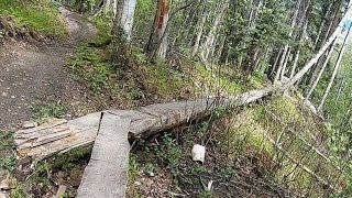
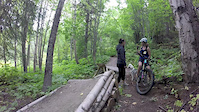
Curvy ribbon of sweet single track goodness flowing across University Hill. Optional jumps and drops sculpted into the natural terrain with a small gap jump off of Token Rock - look before you leap The party can get rowdy when wet but dries quickly after a storm. The upper portion of Pit Party traverses a moderate slope before sending you into the drainage zone where the real party starts. Furry friends along for the ride? Stop at the log ride to give your four legged companions a quick cool off in the dog pool before dropping back in for the final mad dash down the throat of the gully. Everyone loves a good hand job, enjoy.

This trail is unsanctioned.

Recent Activity on Trail

Past Week
  • 0 rides
  •  
6 Months
  • 4 rides
  • 8 miles avg distance
All
  • 49 rides
  • Last: Jun 7, 2026
c1c2c3c4
January
February
March
April
May
June
July
August
September
October
November
December
update trails status or condition

Pit Party Trail Reports

statusdatedescription
Apr 17, 2026 @ 8:32pm (America/Vancouver)
Apr 17, 2026
A few muddy spots. Lots and lots of wet leaves. Those root will getcha. No trees down or snow on the trail. Go party
May 22, 2025 @ 12:34pm
May 22, 2025
All good and I dare say a great way to mix in a change to the usual ride routine!
Apr 22, 2025 @ 7:23pm
Apr 22, 2025
A few muddy spots before the steep section, but good other then those.
Apr 7, 2024 @ 8:18am
Apr 7, 2024
Quite wet and muddy still almost all the way down. Could use a week or so to dry out.
Jul 1, 2022 @ 8:04pm
Jul 1, 2022
more »
Status:
on Apr 17, 2026
Wet
Avg: 3.92 (8 votes)
Your vote: 0

view (671)
close
3D
Trail Conditions
  • Unknown
  • Snow Groomed
  • Snow Packed
  • Snow Covered
  • Snow Cover Partial
  • Freeze/thaw Cycle
  • Icy
  • Prevalent Mud
  • Wet
  • Variable
  • Ideal
  • Dry
  • Very Dry
Trail Flow (Ridden Direction)
Trailforks scans users ridelogs to determine the most popular direction each trail is ridden. A good flowing trail network will have most trails flowing in a single direction according to their intension.
The colour categories are based on what percentage of riders are riding a trail in its intended direction.
  • > 96%
  • > 90%
  • > 80%
  • > 70%
  • > 50%
  • < 50%
  • bi-directional trail
  • no data
Trail Last Ridden
Trailforks scans ridelogs to determine the last time a trail was ridden.
  • < 2 days
  • < 1 week
  • < 2 weeks
  • < 1 month
  • < 6 months
  • > 6 months
Trail Ridden Direction
The intended direction a trail should be ridden.
  • Downhill Only
  • Downhill Primary
  • Both Directions
  • Uphill Primary
  • Uphill Only
  • One Direction
Contribute Details
Colors indicate trail is missing specified detail.
  • Description
  • Photos
  • Description & Photos
  • Videos
Trail Popularity ?
Trailforks scans ridelogs to determine which trails are ridden the most in the last 9 months. Trails are compared with nearby trails in the same city region with a possible 25 colour shades. Think of this as a heatmap, more rides = more kinetic energy = warmer colors.
  • most popular
  • popular
  • less popular
  • not popular
ATV/ORV/OHV Filter
Max Vehicle Width
inches
US Cell Coverage
Legend
cell carrier legend

Radar Time
Activity Recordings
Trailforks uses anonymized public activity data. ?
Activity Recordings
Trailforks uses anonymized public activity data. ?
Personal Heatmap
Activity Types
all / none
Options
2
Date range month
Winter Trails
Warning A routing network for winter maps does not exist. Selecting trails using the winter trails layer has been disabled.
Missing Trails
Most Popular
Least Popular
Trails are colored based on popularity. The more popular a trail is, the more red. Less popular trails trend towards green.
Jump Magnitude Heatmap
Heatmap of where riders jump on trails. Zoom in to see individual jumps, click circles to view jump details.
BC Backroad Status

Service Road Atlas is a free to use, community-driven service for viewing and creating reports on the numerous back-country service roads around B.C. and Alberta.

map legend
Slope Aspect
Direction the slope faces
Flat N NE E SE S SW W NW
Trails Deemphasized
Trails are shown in grey.
disable
Only show trails with no bike usage.
Enable
Suggested Layers
Based on selected activity type

    Save the current map location and zoom level as your default home location whenever this page is loaded.

    Save
        Directions to pit-party trailhead (53.890620, -122.808180)

        Photos

        30 more »
        130 |
        Apr 27, 2019 @ 8:25pm
        Apr 27, 2019
        166 |
        Apr 27, 2019 @ 8:26pm
        Apr 27, 2019
        181 |
        May 4, 2018 @ 9:16pm
        May 4, 2018
        195 |
        Oct 2, 2015 @ 12:54pm
        Oct 2, 2015

        Videos

        5 more »
        Pit party skinny of doom!
        0:37 | 350 | May 29, 2021 , Prince George
        A Bittersweet Walk
        0:59 | 509 | Sep 6, 2015 , Prince George
        night ride
        0:08 | 100 | Jun 15, 2015 , Prince George
        Pit Party 1
        2:20 | 533 | Oct 28, 2013 , Prince George

        3 Reviews & Comments


        We hope you've been enjoying Trailforks!

        Create a FREE account to view trail comments and much more.

        • #18198 - 4,248 views

        Frequently Asked Questions About Pit Party

        Where is Pit Party located?
        Pit Party is located in University Hill, Prince George, British Columbia, Canada. It is part of the University Hill trail network. The trailhead is located at coordinates 53.89062, -122.80818.
        How hard is Pit Party?
        Pit Party is rated as Black Diamond difficulty. The physical rating is Moderate.
        What is the elevation gain for Pit Party?
        The trail has 377 ft of elevation descent. The elevation ranges from 2,001 ft to 2,379 ft.
        Is Pit Party a point to point trail?
        Pit Party is not a point to point trail. The direction is Downhill Primary. The trail type is singletrack.

        Hit the Trail

        Open in App

        Get this trail on your phone instantly.
        open trail in app

        Download Trail

        Save to wishlist, Garmin & download.
        save the trail

        Find Related Routes

        Find routes and users activities that include this trail.
        find routes for this trail

        You must enter a description before submitting.