more stats
1,834 ft
Distance
-330 ft
Descent
00:03:55
Avg time
-330 ft
Altitude change
3,931 ft
Altitude min
4,261 ft
Altitude max
4,261 ft
Altitude start
3,930 ft
Altitude end
-18%
Grade
-57.8%
Grade max
-0.4%
Grade min
1,696 ft
Distance down
72 ft
Distance flat
00:03:55
Avg time

Playground Details

  • Activities
    • Mountain Bike
  • Riding Area
    Fernie Alpine Resort
    Fernie, British Columbia
  • Difficulty Rating
  • Local Popularity
    70 in Mountain Biking
  • Global Ranking
    #80459 in Mountain Biking
  • Trail Type
    Singletrack
  • Bike Type
    DH
  • Direction
    Downhill Only
    Popular Direction Shown
  • TTFs on Trail
    Berm, Drop, Jump, Gap Jump, Log Ride, Skinny, Wallride
  • Land Owner

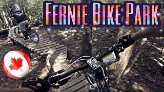
Even big kids like to play This popular trail has technical single track with various stunts and logs to ride. Connect it with Phat Larry's for a top to bottom fun time.

Bike Park

Traditionally Indigenous Territory

Recent Activity on Trail

Past Week
  • 0 rides
  •  
6 Months
  • 0 rides
  •  
All
  • 137 rides
  • Last: Jun 21, 2026
c1c2c3c4
January
February
March
April
May
June
July
August
September
October
November
December
update trails status or condition

Playground Trail Reports

statusdatedescription
Sep 8, 2025 @ 2:16pm
Sep 8, 2025
Closed for the season - will re-open for Fernie Alpine Resort's summer operation in late June 2026.
Aug 10, 2025 @ 3:37pm
Aug 10, 2025
May 29, 2025 @ 11:15am
May 29, 2025
Sep 3, 2024 @ 9:35am
Sep 3, 2024
Closed for the season - will re-open for Fernie Alpine Resort's summer season in late June 2025
Jun 21, 2024 @ 8:19pm
Jun 21, 2024
Open for Fernie Alpine Resort's summer season (June 22 - Sept 2, 2024). Lift ticket or season pass required.
more »
Status:
on Sep 8, 2025
Avg: 3.99 (9 votes)
Your vote: 0

view (1,216)
close
3D
Trail Conditions
  • Unknown
  • Snow Groomed
  • Snow Packed
  • Snow Covered
  • Snow Cover Partial
  • Freeze/thaw Cycle
  • Icy
  • Prevalent Mud
  • Wet
  • Variable
  • Ideal
  • Dry
  • Very Dry
Trail Flow (Ridden Direction)
Trailforks scans users ridelogs to determine the most popular direction each trail is ridden. A good flowing trail network will have most trails flowing in a single direction according to their intension.
The colour categories are based on what percentage of riders are riding a trail in its intended direction.
  • > 96%
  • > 90%
  • > 80%
  • > 70%
  • > 50%
  • < 50%
  • bi-directional trail
  • no data
Trail Last Ridden
Trailforks scans ridelogs to determine the last time a trail was ridden.
  • < 2 days
  • < 1 week
  • < 2 weeks
  • < 1 month
  • < 6 months
  • > 6 months
Trail Ridden Direction
The intended direction a trail should be ridden.
  • Downhill Only
  • Downhill Primary
  • Both Directions
  • Uphill Primary
  • Uphill Only
  • One Direction
Contribute Details
Colors indicate trail is missing specified detail.
  • Description
  • Photos
  • Description & Photos
  • Videos
Trail Popularity ?
Trailforks scans ridelogs to determine which trails are ridden the most in the last 9 months. Trails are compared with nearby trails in the same city region with a possible 25 colour shades. Think of this as a heatmap, more rides = more kinetic energy = warmer colors.
  • most popular
  • popular
  • less popular
  • not popular
ATV/ORV/OHV Filter
Max Vehicle Width
inches
US Cell Coverage
Legend
cell carrier legend

Radar Time
Activity Recordings
Trailforks uses anonymized public activity data. ?
Activity Recordings
Trailforks uses anonymized public activity data. ?
Personal Heatmap
Activity Types
all / none
Options
2
Date range month
Winter Trails
Warning A routing network for winter maps does not exist. Selecting trails using the winter trails layer has been disabled.
Missing Trails
Most Popular
Least Popular
Trails are colored based on popularity. The more popular a trail is, the more red. Less popular trails trend towards green.
Jump Magnitude Heatmap
Heatmap of where riders jump on trails. Zoom in to see individual jumps, click circles to view jump details.
BC Backroad Status

Service Road Atlas is a free to use, community-driven service for viewing and creating reports on the numerous back-country service roads around B.C. and Alberta.

map legend
Slope Aspect
Direction the slope faces
Flat N NE E SE S SW W NW
Trails Deemphasized
Trails are shown in grey.
disable
Only show trails with no bike usage.
Enable
Suggested Layers
Based on selected activity type

    Save the current map location and zoom level as your default home location whenever this page is loaded.

    Save
        Directions to playground-7434 trailhead (49.464450, -115.102480)

        Photos

        11 more »
        263 |
        Feb 3, 2021 @ 5:48pm
        Feb 3, 2021
        339 |
        Feb 3, 2021 @ 5:48pm
        Feb 3, 2021
        294 |
        Jan 13, 2017 @ 9:46am
        Jan 13, 2017
        244 |
        Jul 23, 2015 @ 8:08am
        Jul 23, 2015

        Videos

        2 more »
        This place has everything! | Fernie Bike Park...
        14:00 | 445 | Oct 31, 2019 , Fernie
        Fernie DH Park || Scott Genius || Evo SS
        4:57 | 449 | Aug 21, 2018 , Fernie

        Trail Lists

        Routes with this trail

        19 miles 4,605 ft 15 Race
        Stage 3 of Fernie Singletrack will start and finish at the Nordic Centre in town. We will take you up to...
        13 miles 2,925 ft 9 Race
        Fernie Singletrack short course for stage 3. Starting and finished at the nordic centre this will have...
        19 miles 4,335 ft 60 Loop
        Draft route for Singletrack 6 2020 Stage 2.

        2 Reviews & Comments


        We hope you've been enjoying Trailforks!

        Create a FREE account to view trail comments and much more.

        Frequently Asked Questions About Playground

        Where is Playground located?
        Playground is located in Fernie Alpine Resort, Fernie, British Columbia, Canada. It is part of the Fernie Alpine Resort trail network. The trailhead is located at coordinates 49.46445, -115.10248.
        How hard is Playground?
        Playground is rated as Black Diamond difficulty. The average grade is 18%.
        What is the elevation gain for Playground?
        The trail has 330 ft of elevation descent. The elevation ranges from 3,931 ft to 4,261 ft.
        Is Playground a point to point trail?
        Yes, Playground is a point to point trail. The direction is Downhill Only. The trail type is singletrack.

        Hit the Trail

        Open in App

        Get this trail on your phone instantly.
        open trail in app

        Download Trail

        Save to wishlist, Garmin & download.
        save the trail

        Find Related Routes

        Find routes and users activities that include this trail.
        find routes for this trail

        You must enter a description before submitting.