more stats
5,157 ft
Distance
42 ft
Climb
-998 ft
Descent
00:30:51
Avg time
-958 ft
Altitude change
143 ft
Altitude min
1,135 ft
Altitude max
1,101 ft
Altitude start
144 ft
Altitude end
-18.6%
Grade
-86.5%
Grade max
19.3%
Grade min
597 ft
Distance climb
4,482 ft
Distance down
79 ft
Distance flat
00:30:51
Avg time

Pleasure Trail Details

  • Activities
    • Mountain Bike
    • E-Bike
    • Observed Trials
  • Riding Area
    Alice Lake & Highlands
    Squamish, British Columbia
  • Difficulty Rating
  • Voted Difficulty
    Double Black Diamond (29 votes)
  • Local Popularity
    50 in Mountain Biking [+]
    • 60 in E-Biking
    • 65 in Observed Trials
  • Global Ranking
    #1464 in Mountain Biking [+]
    • #6572 in E-Biking
    • #147 in Observed Trials
  • Trail Type
    Singletrack
  • Bike Type
    AM
  • Direction
    Downhill Only
    Popular Direction Shown
  • Climb Difficulty
    Black Diamond
  • Physical Rating
    Hard
  • Dogs Allowed
    Yes
  • eBike Allowed
    Yes up to Class 1
  • TTFs on Trail
    Bridge, Drop, Jump, Ladder Bridge, Rock Face, Skinny
  • Year Opened
    2017

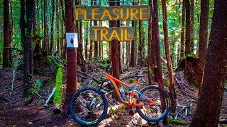
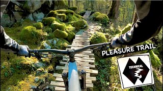
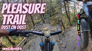
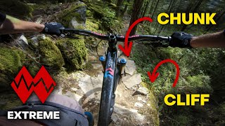
Pleasure trail is a very hard slower-speed highly technical trail with some expert level advanced features. Ride with caution. It has a number of well built wood features. Some rock rolls are quite exposed. A mistake could result in crashes over 10 foot drops.

Your mindset for the first run should be to go very slow into sections with slabs and uncertain run outs.

When very loose and dry, or when wet some sections will be absolutely treacherous.

Trail Supporters
Local Trail Association
Traditionally Indigenous Territory

Recent Activity on Trail

Past Week
  • 0 rides
  •  
6 Months
  • 18 rides
  • 12 miles avg distance
All
  • 312 rides
  • Last: Jun 3, 2026
c1c2c3c4
January
February
March
April
May
June
July
August
September
October
November
December
update trails status or condition

Pleasure Trail Trail Reports

statusdatedescription
May 10, 2026 @ 2:13pm (America/Vancouver)
May 10, 2026
Running great! Still spicy as ever!
Mar 9, 2026 @ 4:22pm (America/Vancouver)
Mar 9, 2026
Trees all cleared -
Jan 3, 2026 @ 8:04am (America/Vancouver)
Jan 3, 2026
Few trees down, some snow remains
Dec 6, 2025 @ 12:34pm (America/Vancouver)
Dec 6, 2025
Tree down mid way across one of the ramps
Oct 16, 2025 @ 3:13pm (America/Vancouver)
Oct 16, 2025
reporter Bridge still out
more »
Status:
on May 10, 2026
Ideal
Avg: 4.83 (85 votes)
Your vote: 0

view (3,218)
close
3D
Trail Conditions
  • Unknown
  • Snow Groomed
  • Snow Packed
  • Snow Covered
  • Snow Cover Partial
  • Freeze/thaw Cycle
  • Icy
  • Prevalent Mud
  • Wet
  • Variable
  • Ideal
  • Dry
  • Very Dry
Trail Flow (Ridden Direction)
Trailforks scans users ridelogs to determine the most popular direction each trail is ridden. A good flowing trail network will have most trails flowing in a single direction according to their intension.
The colour categories are based on what percentage of riders are riding a trail in its intended direction.
  • > 96%
  • > 90%
  • > 80%
  • > 70%
  • > 50%
  • < 50%
  • bi-directional trail
  • no data
Trail Last Ridden
Trailforks scans ridelogs to determine the last time a trail was ridden.
  • < 2 days
  • < 1 week
  • < 2 weeks
  • < 1 month
  • < 6 months
  • > 6 months
Trail Ridden Direction
The intended direction a trail should be ridden.
  • Downhill Only
  • Downhill Primary
  • Both Directions
  • Uphill Primary
  • Uphill Only
  • One Direction
Contribute Details
Colors indicate trail is missing specified detail.
  • Description
  • Photos
  • Description & Photos
  • Videos
Trail Popularity ?
Trailforks scans ridelogs to determine which trails are ridden the most in the last 9 months. Trails are compared with nearby trails in the same city region with a possible 25 colour shades. Think of this as a heatmap, more rides = more kinetic energy = warmer colors.
  • most popular
  • popular
  • less popular
  • not popular
ATV/ORV/OHV Filter
Max Vehicle Width
inches
US Cell Coverage
Legend
cell carrier legend

Radar Time
Activity Recordings
Trailforks uses anonymized public activity data. ?
Activity Recordings
Trailforks uses anonymized public activity data. ?
Personal Heatmap
Activity Types
all / none
Options
2
Date range month
Winter Trails
Warning A routing network for winter maps does not exist. Selecting trails using the winter trails layer has been disabled.
Missing Trails
Most Popular
Least Popular
Trails are colored based on popularity. The more popular a trail is, the more red. Less popular trails trend towards green.
Jump Magnitude Heatmap
Heatmap of where riders jump on trails. Zoom in to see individual jumps, click circles to view jump details.
BC Backroad Status

Service Road Atlas is a free to use, community-driven service for viewing and creating reports on the numerous back-country service roads around B.C. and Alberta.

map legend
Slope Aspect
Direction the slope faces
Flat N NE E SE S SW W NW
Trails Deemphasized
Trails are shown in grey.
disable
Only show trails with no bike usage.
Enable
Suggested Layers
Based on selected activity type

    Save the current map location and zoom level as your default home location whenever this page is loaded.

    Save
        Directions to pleasure-trail trailhead (49.768110, -123.130550)

        Photos

        65 more »
        1,411 |
        Nov 6, 2017 @ 8:41pm
        Nov 6, 2017
        1,311 |
        Nov 6, 2017 @ 8:41pm
        Nov 6, 2017
        1,398 |
        Nov 6, 2017 @ 8:41pm
        Nov 6, 2017
        45 |
        Oct 23, 2025 @ 4:57pm
        Oct 23, 2025

        Videos

        29 more »
        youtuber It is a Pleasure, Trail! New Trail in...
        15:46 | 2049 | Oct 12, 2018 , Squamish
        youtuber PLEASURE TRAIL | Double black trail | Squamish...
        8:39 | 98 | Dec 20, 2023 , Squamish
        youtuber E-Bike on the Pleasure Trail with a Crash or...
        14:08 | 291 | Aug 18, 2024 , Squamish
        youtuber Pleasure Trail | The ROUGHEST Trail I've ever...
        8:57 | 597 | Jul 13, 2023 , Squamish

        Trail Lists

        Routes with this trail

        5.0 39 miles 7,470 ft 24
        A Test Course for how not to ride all day
        10 miles 2,675 ft 18 Loop
        Climb up to Rigs and Zen enjoy the view. Go down Rigs and Zen then turn off at . Go back on trail back to...

        32 Reviews & Comments


        We hope you've been enjoying Trailforks!

        Create a FREE account to view trail comments and much more.

        • By canadakaTF Pro Trailforks & contributors
        • #109299 - 22,622 views

        Frequently Asked Questions About Pleasure Trail

        Where is Pleasure Trail located?
        Pleasure Trail is located in Alice Lake & Highlands, Squamish, British Columbia, Canada. It is part of the Alice Lake & Highlands trail network. The trailhead is located at coordinates 49.76811, -123.13055.
        How hard is Pleasure Trail?
        Pleasure Trail is rated as Double Black Diamond difficulty. The physical rating is Hard. The average grade is 18.6%. The climb difficulty is rated Black Diamond.
        What is the elevation gain for Pleasure Trail?
        Pleasure Trail has 42 ft of elevation gain. The trail has 998 ft of elevation descent. The elevation ranges from 143 ft to 1,135 ft.
        Is Pleasure Trail a point to point trail?
        Yes, Pleasure Trail is a point to point trail. The direction is Downhill Only. The trail type is singletrack.

        Hit the Trail

        Open in App

        Get this trail on your phone instantly.
        open trail in app

        Download Trail

        Save to wishlist, Garmin & download.
        save the trail

        Find Related Routes

        Find routes and users activities that include this trail.
        find routes for this trail

        You must enter a description before submitting.