more stats
1.4 miles
Distance
-705 ft
Descent
00:39:39
Avg time
-705 ft
Altitude change
1,056 ft
Altitude min
1,762 ft
Altitude max
1,761 ft
Altitude start
1,056 ft
Altitude end
-9.3%
Grade
-30.8%
Grade max
0.5%
Grade min
23 ft
Distance climb
1 mile
Distance down
702 ft
Distance flat
00:39:39
Avg time

Poiana Details

  • Activities
    • Mountain Bike
    • Hike
    • Trail Running
  • Riding Area
  • Difficulty Rating
  • Local Popularity
    50 in Mountain Biking [+]
    • 5 in Trail Running
    • 90 in Hiking
  • Global Ranking
    #104783 in Mountain Biking [+]
    • #130691 in Trail Running
    • #25712 in Hiking
  • Hiking SAC Scale
    T1 Hiking
  • Trail Type
    Singletrack
  • Bike Type
    AM
  • Direction
    Downhill Primary
    Popular Direction Shown
  • Dogs Allowed
    Yes
  • TTFs on Trail
    Rock Face, Rock Garden
  • Year Opened
    2018

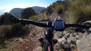
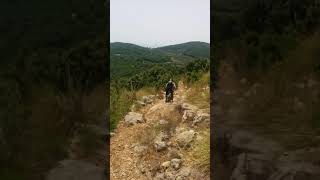
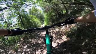
La partenza del sentiero si trova a circa 500 metri dalla Fonte di Santo Stefano direzione Monte Pilucco sulla destra della strada asfaltata subito dopo una radura. Inizia con un tratto pedalato con un segmento moderatamente tecnico seguito da una lunga sezione scorrevole intervallata da brevi rock garden all’interno di un bosco di lecci. Uscendo dal bosco, dopo circa 600 metri dall’inizio del sentiero, si apre una spettacolare vista sul Lago di Fondi e la costa a sud di Terracina fino a Sperlonga. Nemmeno il tempo di ammirare il panorama ed eccoci di nuovo nel bosco dal quale usciremo definitivamente dopo altri 500 metri circa che si concludono con un breve tratto pedalato ed un paio di passaggi che richiedono una certa destrezza. Siamo di nuovo fuori dal bosco, sulla nostra sinistra il panorama della Piana di Fondi e davanti noi altri 400 metri circa pedalati su fondo roccioso con tratti ghiaiosi e parzialmente occupati da massi franati sul sentiero dopo un incendio di qualche anno fa.

La parte pedalata termina su una sporgenza di Monte Giusto rivolta a sud a circa 400 metri sul livello del mare. Da qui possiamo godere di una vista notevole che va da Sperlonga alla costa di Sabaudia. Il punto ideale dove riprendere fiato prima di affrontare la parte più dura del trail.

Gli ultimi 600 metri sono quelli più impegnativi dal punto di vista tecnico e fisico in cui perderemo gli ultimi 125 metri di quota per una pendenza media del 20% circa. Il fondo è roccioso e compatto con diversi passaggi impegnativi su gradoni e rocce affioranti che richiedono una buona padronanza del mezzo per evitare “impuntamenti”.

Concludendo il sentiero è un tipico “all-mountain” dove non mancano tratti molti scorrevoli, sezioni tecniche anche pedalate, rock garden impegnativi e panorami appaganti

Recent Activity on Trail

Past Week
  • 0 rides
  •  
6 Months
  • 1 rides
  • 33 miles avg distance
All
  • 12 rides
  • Last: Apr 11, 2026
c1c2c3c4
January
February
March
April
May
June
July
August
September
October
November
December
update trails status or condition

Poiana Trail Reports

statusdatedescription
Nov 6, 2025 @ 12:28pm (Europe/Rome)
Nov 6, 2025
Mar 8, 2025 @ 9:11am
Mar 8, 2025
Aug 24, 2020 @ 10:37pm
Aug 24, 2020
Jun 17, 2020 @ 2:08pm
Jun 17, 2020
reporter
Rimossa un'altra frana nella parte tecnica. Il sentiero ora è in buono stato anche nella parte alta. Speriamo duri un po'. Qualche roccetta...
Jun 14, 2020 @ 11:01pm
Jun 14, 2020
Rode this trail on Saturday and it was great fun. Still some loose rocks and branches on the top part of the trail lying around but in the more...
more »
Status:
on Nov 6, 2025
Ideal
Avg: 4.24 (2 votes)
Your vote: 0

view (144)
close
3D
Trail Conditions
  • Unknown
  • Snow Groomed
  • Snow Packed
  • Snow Covered
  • Snow Cover Partial
  • Freeze/thaw Cycle
  • Icy
  • Prevalent Mud
  • Wet
  • Variable
  • Ideal
  • Dry
  • Very Dry
Trail Flow (Ridden Direction)
Trailforks scans users ridelogs to determine the most popular direction each trail is ridden. A good flowing trail network will have most trails flowing in a single direction according to their intension.
The colour categories are based on what percentage of riders are riding a trail in its intended direction.
  • > 96%
  • > 90%
  • > 80%
  • > 70%
  • > 50%
  • < 50%
  • bi-directional trail
  • no data
Trail Last Ridden
Trailforks scans ridelogs to determine the last time a trail was ridden.
  • < 2 days
  • < 1 week
  • < 2 weeks
  • < 1 month
  • < 6 months
  • > 6 months
Trail Ridden Direction
The intended direction a trail should be ridden.
  • Downhill Only
  • Downhill Primary
  • Both Directions
  • Uphill Primary
  • Uphill Only
  • One Direction
Contribute Details
Colors indicate trail is missing specified detail.
  • Description
  • Photos
  • Description & Photos
  • Videos
Trail Popularity ?
Trailforks scans ridelogs to determine which trails are ridden the most in the last 9 months. Trails are compared with nearby trails in the same city region with a possible 25 colour shades. Think of this as a heatmap, more rides = more kinetic energy = warmer colors.
  • most popular
  • popular
  • less popular
  • not popular
ATV/ORV/OHV Filter
Max Vehicle Width
inches
US Cell Coverage
Legend
cell carrier legend

Radar Time
Activity Recordings
Trailforks uses anonymized public activity data. ?
Activity Recordings
Trailforks uses anonymized public activity data. ?
Personal Heatmap
Activity Types
all / none
Options
2
Date range month
Winter Trails
Warning A routing network for winter maps does not exist. Selecting trails using the winter trails layer has been disabled.
Missing Trails
Most Popular
Least Popular
Trails are colored based on popularity. The more popular a trail is, the more red. Less popular trails trend towards green.
Jump Magnitude Heatmap
Heatmap of where riders jump on trails. Zoom in to see individual jumps, click circles to view jump details.
BC Backroad Status

Service Road Atlas is a free to use, community-driven service for viewing and creating reports on the numerous back-country service roads around B.C. and Alberta.

map legend
Slope Aspect
Direction the slope faces
Flat N NE E SE S SW W NW
Trails Deemphasized
Trails are shown in grey.
disable
Only show trails with no bike usage.
Enable
Suggested Layers
Based on selected activity type

    Save the current map location and zoom level as your default home location whenever this page is loaded.

    Save
        Directions to poiana trailhead (41.329380, 13.286280)

        Photos

        10 more »
        123 |
        Jun 18, 2020 @ 4:14am
        Jun 18, 2020
        160 |
        Apr 5, 2019 @ 1:44am
        Apr 5, 2019
        116 |
        Jun 17, 2020 @ 2:08pm
        Jun 17, 2020
        124 |
        Jun 17, 2020 @ 2:08pm
        Jun 17, 2020

        Videos

        3 more »
        Poiana Enduro - Terracina Network Trail
        5:57 | 144 | Jun 27, 2023 , Terracina
        Poiana rocks
        0:14 | 527 | Jul 24, 2018 , Terracina
        Poiana Full
        16:09 | 491 | Jul 23, 2018 , Terracina

        Routes with this trail

        5.0 20 miles 3,235 ft 3 Loop
        All mountain route in Terracina with the trails , e
        5 miles 995 ft 2 Loop
        Giro ad anello che percorre e partendo dalla Fonte di Santo Stefano. L'anello fa parte del percorso CAI...
        12 miles 2,069 ft 5 Loop Race
        Percorso definitivo del TeTC2019

        Reviews / Comments

        No reviews yet, be the first to write a review or ask a question.
        Use trail reports to comment on trail conditions.


        We hope you've been enjoying Trailforks!

        Create a FREE account to view trail comments and much more.

        • By taylerlazarin & contributors
        • #130650 - 1,708 views

        Frequently Asked Questions About Poiana

        Where is Poiana located?
        Poiana is located in Terracina Network Trails, Terracina, Italy. It is part of the Terracina Network Trails trail network. The trailhead is located at coordinates 41.32938, 13.28628.
        How hard is Poiana?
        Poiana is rated as Red difficulty. The average grade is 9.3%.
        What is the elevation gain for Poiana?
        The trail has 705 ft of elevation descent. The elevation ranges from 1,056 ft to 1,762 ft.
        Is Poiana a point to point trail?
        Poiana is not a point to point trail. The direction is Downhill Primary. The trail type is singletrack.

        Hit the Trail

        Open in App

        Get this trail on your phone instantly.
        open trail in app

        Download Trail

        Save to wishlist, Garmin & download.
        save the trail

        Find Related Routes

        Find routes and users activities that include this trail.
        find routes for this trail

        You must enter a description before submitting.