more stats
1,732 ft
Distance
13 ft
Climb
-6 ft
Descent
00:02:22
Avg time
9 ft
Altitude change
235 ft
Altitude min
247 ft
Altitude max
238 ft
Altitude start
246 ft
Altitude end
0.5%
Grade
-4.2%
Grade max
5.8%
Grade min
436 ft
Distance climb
249 ft
Distance down
955 ft
Distance flat
00:02:22
Avg time

Pond Backside Details

  • Activities
    • Hike
    • Winter Fat Bike
    • Horse
    • Trail Running
  • Riding Area
    Los Peñasquitos Canyon
    San Diego, California
  • Difficulty Rating
  • Voted Difficulty
    Blue (3 votes)
  • Local Popularity
    85 in Hiking [+]
    • 30 in Trail Running
    • 5 in Horseback
  • Global Ranking
    #55531 in Hiking [+]
    • #128110 in Trail Running
    • #8284 in Horseback
  • Hiking SAC Scale
    T1 Hiking
  • Trail Type
    Singletrack
  • Direction
    Both Directions
    Popular Direction Shown
  • Climb Difficulty
    Green
  • Physical Rating
    Easy
  • Trail Visibility
    Always easy to follow
  • Family Friendly
    Yes
  • Dogs Allowed
    Yes
  • eBike Allowed
  • Land Owner
    City of San Diego

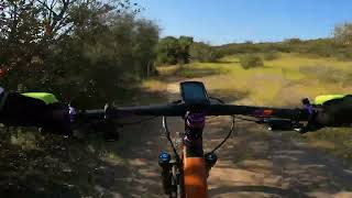
Alternate path around the back side of the pond. Good for heading north and avoiding traffic on the main trail.

ADAPTIVE MTB INFO
Rating: aMTB2 - Obstacles Exist - Narrow Camber - Support Rider Recommended

Adaptive Riders, you will most likely need a spot going through here. Probably not worth it. Staying on main trail recommended.

Traditionally Indigenous Territory

Recent Activity on Trail

Past Week
  • 0 rides
  •  
6 Months
  • 0 rides
  •  
All
  • 10 rides
  •  
c1c2c3c4
January
February
March
April
May
June
July
August
September
October
November
December
update trails status or condition

Pond Backside Trail Reports

Status:
on Aug 11, 2024
Variable
Avg: 3.75 (4 votes)
Your vote: 0

view (5,144)
close
3D
Trail Conditions
  • Unknown
  • Snow Groomed
  • Snow Packed
  • Snow Covered
  • Snow Cover Partial
  • Freeze/thaw Cycle
  • Icy
  • Prevalent Mud
  • Wet
  • Variable
  • Ideal
  • Dry
  • Very Dry
Trail Flow (Ridden Direction)
Trailforks scans users ridelogs to determine the most popular direction each trail is ridden. A good flowing trail network will have most trails flowing in a single direction according to their intension.
The colour categories are based on what percentage of riders are riding a trail in its intended direction.
  • > 96%
  • > 90%
  • > 80%
  • > 70%
  • > 50%
  • < 50%
  • bi-directional trail
  • no data
Trail Last Ridden
Trailforks scans ridelogs to determine the last time a trail was ridden.
  • < 2 days
  • < 1 week
  • < 2 weeks
  • < 1 month
  • < 6 months
  • > 6 months
Trail Ridden Direction
The intended direction a trail should be ridden.
  • Downhill Only
  • Downhill Primary
  • Both Directions
  • Uphill Primary
  • Uphill Only
  • One Direction
Contribute Details
Colors indicate trail is missing specified detail.
  • Description
  • Photos
  • Description & Photos
  • Videos
Trail Popularity ?
Trailforks scans ridelogs to determine which trails are ridden the most in the last 9 months. Trails are compared with nearby trails in the same city region with a possible 25 colour shades. Think of this as a heatmap, more rides = more kinetic energy = warmer colors.
  • most popular
  • popular
  • less popular
  • not popular
ATV/ORV/OHV Filter
Max Vehicle Width
inches
US Cell Coverage
Legend
cell carrier legend

Radar Time
Activity Recordings
Trailforks uses anonymized public activity data. ?
Activity Recordings
Trailforks uses anonymized public activity data. ?
Personal Heatmap
Activity Types
all / none
Options
2
Date range month
Winter Trails
Warning A routing network for winter maps does not exist. Selecting trails using the winter trails layer has been disabled.
Missing Trails
Most Popular
Least Popular
Trails are colored based on popularity. The more popular a trail is, the more red. Less popular trails trend towards green.
Jump Magnitude Heatmap
Heatmap of where riders jump on trails. Zoom in to see individual jumps, click circles to view jump details.
BC Backroad Status

Service Road Atlas is a free to use, community-driven service for viewing and creating reports on the numerous back-country service roads around B.C. and Alberta.

map legend
Slope Aspect
Direction the slope faces
Flat N NE E SE S SW W NW
Trails Deemphasized
Trails are shown in grey.
disable
Only show trails with no bike usage.
Enable
Suggested Layers
Based on selected activity type

    Save the current map location and zoom level as your default home location whenever this page is loaded.

    Save
        Directions to pond-backside trailhead (32.934030, -117.176830)

        Photos

        1 more »
        28 |
        Feb 20, 2023 @ 8:16am
        Feb 20, 2023

        Videos

        1 more »
        Pond Backside - Penasquitos Canyon, San Diego
        2:34 | 76 | Apr 30, 2022 , San Diego

        1 Review & Comments


        We hope you've been enjoying Trailforks!

        Create a FREE account to view trail comments and much more.

        • By brianpetryTF Pro TRAILFORKS & contributors
        • #139494 - 927 views

        Frequently Asked Questions About Pond Backside

        Where is Pond Backside located?
        Pond Backside is located in Los Peñasquitos Canyon, San Diego, California, United States. It is part of the Los Peñasquitos Canyon trail network. The trailhead is located at coordinates 32.93403, -117.17683.
        How hard is Pond Backside?
        Pond Backside is rated as Green difficulty. The physical rating is Easy. The average grade is 0.5%. The climb difficulty is rated Green.
        What is the elevation gain for Pond Backside?
        Pond Backside has 13 ft of elevation gain. The trail has 6 ft of elevation descent. The elevation ranges from 235 ft to 247 ft.
        Is Pond Backside a point to point trail?
        Pond Backside is not a point to point trail. The direction is Both Directions. The trail type is singletrack.

        Hit the Trail

        Open in App

        Get this trail on your phone instantly.
        open trail in app

        Download Trail

        Save to wishlist, Garmin & download.
        save the trail

        Find Related Routes

        Find routes and users activities that include this trail.
        find routes for this trail

        You must enter a description before submitting.