more stats
2,959 ft
Distance
-260 ft
Descent
00:10:49
Avg time
-260 ft
Altitude change
2,337 ft
Altitude min
2,597 ft
Altitude max
2,597 ft
Altitude start
2,336 ft
Altitude end
-8.8%
Grade
-28.6%
Grade max
1.1%
Grade min
2,782 ft
Distance down
144 ft
Distance flat
00:10:49
Avg time

Pop Rocks Details

  • Activities
    • Mountain Bike
    • E-Bike
    • Winter Fat Bike
  • Riding Area
    Beacon Hill
    Spokane, Washington
  • Difficulty Rating
  • Local Popularity
    90 in Mountain Biking [+]
    • 90 in E-Biking
  • Global Ranking
    #40287 in Mountain Biking [+]
    • #23632 in E-Biking
  • Trail Type
    Singletrack
  • Bike Type
    DH, AM, XC, Fat
  • Direction
    Downhill Only
    Popular Direction Shown
  • Physical Rating
    Moderate
  • Trail Visibility
    Always easy to follow
  • Dogs Allowed
    Yes
  • eBike Allowed
    Yes up to Class 1
  • TTFs on Trail
    Berm, Drop, Jump, Gap Jump, Rock Face, Rock Garden
  • Land Owner
    Evergreen East Mountain Bike Alliance

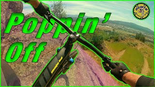
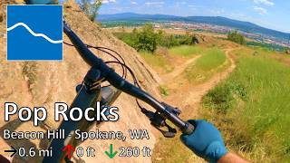
Pop Rocks is an intermediate tech trail with several rock gardens and rock rolls to navigate through. Look for an upper, more advanced line towards the top section of trail. Half way down the trail is a giant rock slab locals refer to as the gnar wall. This trail is a great place to get comfortable on classic Beacon rocks.

Access Info

At the top of the towers head south, look for a small off camber rock roll into rock garden under the power lines.

Trail Supporters

  • Tim Schlosser
    Maintainer
  • Alexey Florianavich
    Maintainer
  • Peter Jantz
    Builder
  • Eric Ashley
    Builder
Local Trail Association
Traditionally Indigenous Territory

Recent Activity on Trail

Past Week
  • 1 rides
  • 14.5 km average
6 Months
  • 61 rides
  • 17.6 km avg distance
All
  • 764 rides
  • Last: Jun 15, 2026
c1c2c3c4
January
February
March
April
May
June
July
August
September
October
November
December
Status:
on May 6, 2026
Dry
Avg: 4.34 (17 votes)
Your vote: 0

view (4,861)
close
3D
Trail Conditions
  • Unknown
  • Snow Groomed
  • Snow Packed
  • Snow Covered
  • Snow Cover Partial
  • Freeze/thaw Cycle
  • Icy
  • Prevalent Mud
  • Wet
  • Variable
  • Ideal
  • Dry
  • Very Dry
Trail Flow (Ridden Direction)
Trailforks scans users ridelogs to determine the most popular direction each trail is ridden. A good flowing trail network will have most trails flowing in a single direction according to their intension.
The colour categories are based on what percentage of riders are riding a trail in its intended direction.
  • > 96%
  • > 90%
  • > 80%
  • > 70%
  • > 50%
  • < 50%
  • bi-directional trail
  • no data
Trail Last Ridden
Trailforks scans ridelogs to determine the last time a trail was ridden.
  • < 2 days
  • < 1 week
  • < 2 weeks
  • < 1 month
  • < 6 months
  • > 6 months
Trail Ridden Direction
The intended direction a trail should be ridden.
  • Downhill Only
  • Downhill Primary
  • Both Directions
  • Uphill Primary
  • Uphill Only
  • One Direction
Contribute Details
Colors indicate trail is missing specified detail.
  • Description
  • Photos
  • Description & Photos
  • Videos
Trail Popularity ?
Trailforks scans ridelogs to determine which trails are ridden the most in the last 9 months. Trails are compared with nearby trails in the same city region with a possible 25 colour shades. Think of this as a heatmap, more rides = more kinetic energy = warmer colors.
  • most popular
  • popular
  • less popular
  • not popular
ATV/ORV/OHV Filter
Max Vehicle Width
inches
US Cell Coverage
Legend
cell carrier legend

Radar Time
Activity Recordings
Trailforks uses anonymized public activity data. ?
Activity Recordings
Trailforks uses anonymized public activity data. ?
Personal Heatmap
Activity Types
all / none
Options
2
Date range month
Winter Trails
Warning A routing network for winter maps does not exist. Selecting trails using the winter trails layer has been disabled.
Missing Trails
Most Popular
Least Popular
Trails are colored based on popularity. The more popular a trail is, the more red. Less popular trails trend towards green.
Jump Magnitude Heatmap
Heatmap of where riders jump on trails. Zoom in to see individual jumps, click circles to view jump details.
BC Backroad Status

Service Road Atlas is a free to use, community-driven service for viewing and creating reports on the numerous back-country service roads around B.C. and Alberta.

map legend
Slope Aspect
Direction the slope faces
Flat N NE E SE S SW W NW
Trails Deemphasized
Trails are shown in grey.
disable
Only show trails with no bike usage.
Enable
Suggested Layers
Based on selected activity type

    Save the current map location and zoom level as your default home location whenever this page is loaded.

    Save
        Directions to pop-rocks trailhead (47.694180, -117.334630)

        Photos

        72 more »
        39 |
        Oct 5, 2025 @ 8:05am
        Oct 5, 2025
        34 |
        Oct 5, 2025 @ 8:05am
        Oct 5, 2025
        41 |
        Oct 5, 2025 @ 8:05am
        Oct 5, 2025
        39 |
        Oct 5, 2025 @ 8:05am
        Oct 5, 2025

        Videos

        13 more »
        youtuber Alternate Lines on Pop Rocks and Master...
        6:25 | 374 | Jun 4, 2021 , Spokane
        youtuber Pop Rocks - Beacon Hill - Spokane, WA
        21 | Jun 1, 2026 , Spokane
        youtuber The People's Enduro 2017 | Stage 2 Pop Rocks
        3:47 | 623 | Apr 4, 2017 , Spokane
        Beacon Hill - Pop Rocks to parking lot
        104 | May 2, 2025 , Spokane

        Routes with this trail

        4.0 9 miles 1,715 ft 33
        How to hit all the best trails in one ride! All kinds of different trails, technical, flowy, and...
        1 mile 6
        This is stage 3 of Hubapalooza 2023, and has changed from the original rout, please pay attention to ALL...
        1 mile 4
        This is stage 1 for Hubapalooza 2024 enduro

        2 Reviews & Comments


        We hope you've been enjoying Trailforks!

        Create a FREE account to view trail comments and much more.

        • By TimRidesBikesTF Pro & contributors
        • #44714 - 4,764 views

        Frequently Asked Questions About Pop Rocks

        Where is Pop Rocks located?
        Pop Rocks is located in Beacon Hill, Spokane, Washington, United States. It is part of the Beacon Hill trail network. The trailhead is located at coordinates 47.69418, -117.33463.
        How hard is Pop Rocks?
        Pop Rocks is rated as Blue difficulty. The physical rating is Moderate. The average grade is 8.8%.
        What is the elevation gain for Pop Rocks?
        The trail has 260 ft of elevation descent. The elevation ranges from 2,337 ft to 2,597 ft.
        Is Pop Rocks a point to point trail?
        Yes, Pop Rocks is a point to point trail. The direction is Downhill Only. The trail type is singletrack.

        Hit the Trail

        Open in App

        Get this trail on your phone instantly.
        open trail in app

        Download Trail

        Save to wishlist, Garmin & download.
        save the trail

        Find Related Routes

        Find routes and users activities that include this trail.
        find routes for this trail

        You must enter a description before submitting.