more stats
1.8 miles
Distance
8 ft
Climb
-1,668 ft
Descent
00:15:01
Avg time
-1,660 ft
Altitude change
4,954 ft
Altitude min
6,614 ft
Altitude max
6,614 ft
Altitude start
4,954 ft
Altitude end
-17.92%
Grade
-52.056%
Grade max
6.258%
Grade min
204 ft
Distance climb
2 miles
Distance down
59 ft
Distance flat
00:15:01
Avg time

Porera Rock Details

  • Activities
    • Mountain Bike
    • E-Bike
    • Hike
    • Trail Running
  • Riding Area
  • Difficulty Rating
  • Voted Difficulty
    Black (1 vote)
  • Global Ranking
    #127519 in Mountain Biking [+]
    • #181904 in E-Biking
    • #348256 in Trail Running
    • #357517 in Hiking
  • Hiking SAC Scale
    T5 Demanding Alpine Hiking
  • Trail Type
    Singletrack
  • Bike Type
    DH, AM
  • Direction
    Downhill Only
    Popular Direction Shown
  • Physical Rating
    Moderate
  • Trail Visibility
    Sometimes hard to follow
  • Season
    spring, summer, fall
  • Alpine Trail
    Yes
  • eBike Allowed
    Yes up to Class 1
  • TTFs on Trail
    Rock Face, Rock Garden, Skinny

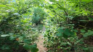
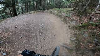
Trail tecnico con algun paso dificil de roca. Camino compartido con senderistas, al cruzarse frenad y ceded el paso.

Access Info

carretera banhs de tredos y pista forestal dirección Porera

Disclaimer

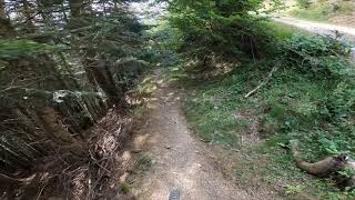
Camino compartido , cuidado

Local Trail Association

Recent Activity on Trail

Past Week
  • 0 rides
  •  
6 Months
  • 0 rides
  •  
All
  • 11 rides
  • Last: May 10, 2026
c1c2c3c4
January
February
March
April
May
June
July
August
September
October
November
December
update trails status or condition

Porera Rock Trail Reports

statusdatedescription
Jun 8, 2026 @ 1:02am (Europe/Madrid)
Jun 7, 2026
Bastante sucia de ramas palos y pedrolos. Hay que tener cuidado con los golpes en el cambio
May 20, 2025 @ 8:11am
May 20, 2025
reporter Sin arboles caidos. Tramo final, hierba que oculta las piedras.
Jun 13, 2024 @ 10:11am
Jun 13, 2024
Hay un par de tramos con arboles caídos, sobre todo uno en un tramo con pendiente y toca bajarse de la bici. Hay q pasarlo por debajo agachandose...
Oct 28, 2023 @ 2:03am
Oct 28, 2023
almost ideal, perfect grip, some roots or rocks a bit moist
Oct 5, 2023 @ 1:49am
Oct 5, 2023
more »
Status:
on Jun 8, 2026
Variable
Avg: 4.56 (8 votes)
Your vote: 0

view (76)
close
3D
Trail Conditions
  • Unknown
  • Snow Groomed
  • Snow Packed
  • Snow Covered
  • Snow Cover Partial
  • Freeze/thaw Cycle
  • Icy
  • Prevalent Mud
  • Wet
  • Variable
  • Ideal
  • Dry
  • Very Dry
Trail Flow (Ridden Direction)
Trailforks scans users ridelogs to determine the most popular direction each trail is ridden. A good flowing trail network will have most trails flowing in a single direction according to their intension.
The colour categories are based on what percentage of riders are riding a trail in its intended direction.
  • > 96%
  • > 90%
  • > 80%
  • > 70%
  • > 50%
  • < 50%
  • bi-directional trail
  • no data
Trail Last Ridden
Trailforks scans ridelogs to determine the last time a trail was ridden.
  • < 2 days
  • < 1 week
  • < 2 weeks
  • < 1 month
  • < 6 months
  • > 6 months
Trail Ridden Direction
The intended direction a trail should be ridden.
  • Downhill Only
  • Downhill Primary
  • Both Directions
  • Uphill Primary
  • Uphill Only
  • One Direction
Contribute Details
Colors indicate trail is missing specified detail.
  • Description
  • Photos
  • Description & Photos
  • Videos
Trail Popularity ?
Trailforks scans ridelogs to determine which trails are ridden the most in the last 9 months. Trails are compared with nearby trails in the same city region with a possible 25 colour shades. Think of this as a heatmap, more rides = more kinetic energy = warmer colors.
  • most popular
  • popular
  • less popular
  • not popular
ATV/ORV/OHV Filter
Max Vehicle Width
inches
US Cell Coverage
Legend
cell carrier legend

Radar Time
Activity Recordings
Trailforks uses anonymized public activity data. ?
Activity Recordings
Trailforks uses anonymized public activity data. ?
Personal Heatmap
Activity Types
all / none
Options
2
Date range month
Winter Trails
Warning A routing network for winter maps does not exist. Selecting trails using the winter trails layer has been disabled.
Missing Trails
Most Popular
Least Popular
Trails are colored based on popularity. The more popular a trail is, the more red. Less popular trails trend towards green.
Jump Magnitude Heatmap
Heatmap of where riders jump on trails. Zoom in to see individual jumps, click circles to view jump details.
BC Backroad Status

Service Road Atlas is a free to use, community-driven service for viewing and creating reports on the numerous back-country service roads around B.C. and Alberta.

map legend
Slope Aspect
Direction the slope faces
Flat N NE E SE S SW W NW
Trails Deemphasized
Trails are shown in grey.
disable
Only show trails with no bike usage.
Enable
Suggested Layers
Based on selected activity type

    Save the current map location and zoom level as your default home location whenever this page is loaded.

    Save
        Directions to porera-rock trailhead (42.682860, 0.931540)

        Photos

        14 more »
        58 |
        Aug 16, 2022 @ 4:09am
        Aug 16, 2022
        65 |
        Aug 16, 2022 @ 4:08am
        Aug 16, 2022
        64 |
        Aug 16, 2022 @ 4:07am
        Aug 16, 2022
        67 |
        Aug 16, 2022 @ 4:07am
        Aug 16, 2022

        Videos

        4 more »
        youtuber Porera Rock parte 1
        8:52 | 44 | Aug 22, 2020 , My City
        youtuber Porera Rock parte 2
        2:49 | 58 | Aug 22, 2020 , My City
        youtuber Bassa d'Oles Blue DH
        437 | Sep 27, 2020 , My City
        youtuber Antenas de Vielha
        235 | Sep 27, 2020 , My City

        Trail Lists

        5 Reviews & Comments


        We hope you've been enjoying Trailforks!

        Create a FREE account to view trail comments and much more.

        • By MarcscanTF Pro OCB & contributors
        • #105009 - 1,773 views

        Frequently Asked Questions About Porera Rock

        Where is Porera Rock located?
        Porera Rock is located in Val d'Aran, Spain. It is part of the Val d'Aran trail network. The trailhead is located at coordinates 42.68286, 0.93154.
        How hard is Porera Rock?
        Porera Rock is rated as Black difficulty. The physical rating is Moderate. The average grade is 17.92%.
        What is the elevation gain for Porera Rock?
        Porera Rock has 8 ft of elevation gain. The trail has 1,668 ft of elevation descent. The elevation ranges from 4,954 ft to 6,614 ft.
        Is Porera Rock a point to point trail?
        Yes, Porera Rock is a point to point trail. The direction is Downhill Only. The trail type is singletrack.

        Hit the Trail

        Open in App

        Get this trail on your phone instantly.
        open trail in app

        Download Trail

        Save to wishlist, Garmin & download.
        save the trail

        Find Related Routes

        Find routes and users activities that include this trail.
        find routes for this trail

        You must enter a description before submitting.