more stats
2.5 miles
Distance
121 ft
Climb
-1,037 ft
Descent
00:14:33
Avg time
-918 ft
Altitude change
744 ft
Altitude min
1,761 ft
Altitude max
1,663 ft
Altitude start
745 ft
Altitude end
-7%
Grade
-43.6%
Grade max
13.4%
Grade min
3,159 ft
Distance climb
2 miles
Distance down
479 ft
Distance flat
00:14:33
Avg time

Lower Priest Rock Details

  • Activities
    • Mountain Bike
    • Gravel Bike
    • Horse
    • Hike
    • Trail Running
  • Riding Area
    Sierra Azul Open Space Preserve
    Los Gatos, California
  • Difficulty Rating
  • Voted Difficulty
    Green (1 vote)
  • Local Popularity
    65 in Mountain Biking [+]
    • 70 in Trail Running
    • 50 in Hiking
    • 5 in Horseback
  • Hiking SAC Scale
    T2 Mountain Hiking
  • Trail Type
    Dirt/Gravel Road
  • Bike Type
    AM, XC, Gravel
  • Direction
    Both Directions[+]
    Popular Direction Shown
    • Both Directions for Horseback
    • Both Directions for Gravel Biking
  • Climb Difficulty
    Blue
  • Physical Rating
    Hard
  • Trail Visibility
    Always easy to follow
  • Season
    All Year
  • Dogs Allowed
    Yes
  • Ride in Rain
    Yes
  • Land Owner

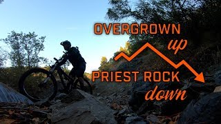
Lower Priest Rock traverses the ridge of some of the highest hills around Lexington Reservoir. It begins at Alma Bridge Road and climbs up to the top of Limekiln Trail where it intersects with Upper Priest Rock. Along the way, you will experience challenging rocky sections, some tree cover, and several sections that are so steep they are almost unrideable. This trail can get very hot in the summertime.

The descent from Kennedy is technical and fast. Riding down the upper section of this trail is for moderate and advanced riders due to the steepness and off-camber turns. Many have crashed - some badly - on this trail. The lower section is also steep, but far easier to navigate.

Local Trail Association
Traditionally Indigenous Territory

Recent Activity on Trail

Past Week
  • 1 rides
  • 11 miles average
6 Months
  • 20 rides
  • 20 miles avg distance
All
  • 142 rides
  • Last: Jun 19, 2026
c1c2c3c4
January
February
March
April
May
June
July
August
September
October
November
December
update trails status or condition

Lower Priest Rock Trail Reports

statusdatedescription
May 26, 2025 @ 12:36pm
May 26, 2025
Feb 2, 2025 @ 2:20pm
Feb 2, 2025
Jun 19, 2023 @ 7:38am
Jun 19, 2023
took it in the descending direction. Trail is loose, but as long as speed is under control not dangerous. There are ruts in some corners, be...
May 25, 2022 @ 5:30am
May 25, 2022
May 1, 2022 @ 8:46pm
May 1, 2022
Dry, rocky, and sketchy. Some deep ruts, but the lower section is leveled and should be smooth until Winter.
more »
Status:
on May 26, 2025
Very Dry
Avg: 3.65 (3 votes)
Your vote: 0

view (1,464)
close
3D
Trail Conditions
  • Unknown
  • Snow Groomed
  • Snow Packed
  • Snow Covered
  • Snow Cover Partial
  • Freeze/thaw Cycle
  • Icy
  • Prevalent Mud
  • Wet
  • Variable
  • Ideal
  • Dry
  • Very Dry
Trail Flow (Ridden Direction)
Trailforks scans users ridelogs to determine the most popular direction each trail is ridden. A good flowing trail network will have most trails flowing in a single direction according to their intension.
The colour categories are based on what percentage of riders are riding a trail in its intended direction.
  • > 96%
  • > 90%
  • > 80%
  • > 70%
  • > 50%
  • < 50%
  • bi-directional trail
  • no data
Trail Last Ridden
Trailforks scans ridelogs to determine the last time a trail was ridden.
  • < 2 days
  • < 1 week
  • < 2 weeks
  • < 1 month
  • < 6 months
  • > 6 months
Trail Ridden Direction
The intended direction a trail should be ridden.
  • Downhill Only
  • Downhill Primary
  • Both Directions
  • Uphill Primary
  • Uphill Only
  • One Direction
Contribute Details
Colors indicate trail is missing specified detail.
  • Description
  • Photos
  • Description & Photos
  • Videos
Trail Popularity ?
Trailforks scans ridelogs to determine which trails are ridden the most in the last 9 months. Trails are compared with nearby trails in the same city region with a possible 25 colour shades. Think of this as a heatmap, more rides = more kinetic energy = warmer colors.
  • most popular
  • popular
  • less popular
  • not popular
ATV/ORV/OHV Filter
Max Vehicle Width
inches
US Cell Coverage
Legend
cell carrier legend

Radar Time
Activity Recordings
Trailforks uses anonymized public activity data. ?
Activity Recordings
Trailforks uses anonymized public activity data. ?
Personal Heatmap
Activity Types
all / none
Options
2
Date range month
Winter Trails
Warning A routing network for winter maps does not exist. Selecting trails using the winter trails layer has been disabled.
Missing Trails
Most Popular
Least Popular
Trails are colored based on popularity. The more popular a trail is, the more red. Less popular trails trend towards green.
Jump Magnitude Heatmap
Heatmap of where riders jump on trails. Zoom in to see individual jumps, click circles to view jump details.
BC Backroad Status

Service Road Atlas is a free to use, community-driven service for viewing and creating reports on the numerous back-country service roads around B.C. and Alberta.

map legend
Slope Aspect
Direction the slope faces
Flat N NE E SE S SW W NW
Trails Deemphasized
Trails are shown in grey.
disable
Only show trails with no bike usage.
Enable
Suggested Layers
Based on selected activity type

    Save the current map location and zoom level as your default home location whenever this page is loaded.

    Save
        Directions to lower-priest-rock trailhead (37.192740, -121.956980)

        Photos

        No photos have been added for Lower Priest Rock yet, add a photo.

        Videos

        2 more »
        youtuber Turkey Day 2021
        5:23 | 250 | Nov 27, 2021 , Los Gatos
        Overgrown Up and Priest Down
        10:34 | 453 | Aug 11, 2020 , Los Gatos

        Routes with this trail

        12 miles 2,750 ft 6 Point to Point
        This trail starts at kennedy trail and begins to climb for about 4 miles then from there it is down hill...
        10 miles 2,714 ft 5 Loop
        Easy loop in South Bay with a good climb.
        2.0 28 miles 6,283 ft 8 Out & Back
        Ride to Mount Umunhum from the Lexington Reservoir. Can start from downtown Los Gatos and end at a nice...

        1 Review & Comments


        We hope you've been enjoying Trailforks!

        Create a FREE account to view trail comments and much more.

        Frequently Asked Questions About Lower Priest Rock

        Where is Lower Priest Rock located?
        Lower Priest Rock is located in Sierra Azul Open Space Preserve, Los Gatos, California, United States. It is part of the Sierra Azul Open Space Preserve trail network. The trailhead is located at coordinates 37.19274, -121.95698.
        What is the elevation gain for Lower Priest Rock?
        Lower Priest Rock has 121 ft of elevation gain. The trail has 1,037 ft of elevation descent. The elevation ranges from 744 ft to 1,761 ft.
        Is Lower Priest Rock a point to point trail?
        Lower Priest Rock is not a point to point trail. The direction is Both Directions. The trail type is dirt/gravel road.
        How long is Lower Priest Rock?
        Lower Priest Rock is 2.5 miles long. The trail type is dirt/gravel road.

        Hit the Trail

        Open in App

        Get this trail on your phone instantly.
        open trail in app

        Download Trail

        Save to wishlist, Garmin & download.
        save the trail

        Find Related Routes

        Find routes and users activities that include this trail.
        find routes for this trail

        You must enter a description before submitting.