more stats
1.2 miles
Distance
-852 ft
Descent
00:06:32
Avg time
-853 ft
Altitude change
5,368 ft
Altitude min
6,221 ft
Altitude max
6,221 ft
Altitude start
5,367 ft
Altitude end
-13.9%
Grade
-46%
Grade max
1 mile
Distance down
92 ft
Distance flat
00:06:32
Avg time

PRIMEline Details

  • Activities
    • Mountain Bike
    • E-Bike
  • Riding Area
    Bike Kingdom Park
    Arosa Lenzerheide
  • Difficulty Rating
  • Voted Difficulty
    Red (2 votes)
  • Local Popularity
    60 in Mountain Biking [+]
    • 50 in E-Biking
  • Global Ranking
    #29388 in Mountain Biking [+]
    • #86600 in E-Biking
  • Trail Type
    Machine Groomed
  • Bike Type
    DH, AM
  • Direction
    Downhill Only
    Popular Direction Shown
  • eBike Allowed
    Yes up to Class 1
  • Land Owner

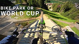
Speed, flow and airtime characterize the PRIMEline. The red route is the most popular among our guests and requires medium to good riding skills. Due to its design, it offers you the possibility to use transfers to drive new and creative lines. So get off the brakes, let it run and enjoy proper adrenaline.

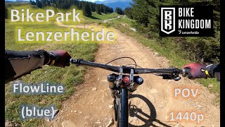
Klassische Freeridestrecke mit Anlegern, Steilwandkurven, Sprüngen und North Shore Elementen, mit teilweise neuer Linienführung.

Bike Park

Recent Activity on Trail

Past Week
  • 2 rides
  • 38.3 km average
6 Months
  • 18 rides
  • 35.0 km avg distance
All
  • 520 rides
  • Last: Jun 20, 2026
c1c2c3c4
January
February
March
April
May
June
July
August
September
October
November
December
Status:
on May 30, 2026
Ideal
Avg: 4.12 (28 votes)
Your vote: 0

view (9,807)
close
3D
Trail Conditions
  • Unknown
  • Snow Groomed
  • Snow Packed
  • Snow Covered
  • Snow Cover Partial
  • Freeze/thaw Cycle
  • Icy
  • Prevalent Mud
  • Wet
  • Variable
  • Ideal
  • Dry
  • Very Dry
Trail Flow (Ridden Direction)
Trailforks scans users ridelogs to determine the most popular direction each trail is ridden. A good flowing trail network will have most trails flowing in a single direction according to their intension.
The colour categories are based on what percentage of riders are riding a trail in its intended direction.
  • > 96%
  • > 90%
  • > 80%
  • > 70%
  • > 50%
  • < 50%
  • bi-directional trail
  • no data
Trail Last Ridden
Trailforks scans ridelogs to determine the last time a trail was ridden.
  • < 2 days
  • < 1 week
  • < 2 weeks
  • < 1 month
  • < 6 months
  • > 6 months
Trail Ridden Direction
The intended direction a trail should be ridden.
  • Downhill Only
  • Downhill Primary
  • Both Directions
  • Uphill Primary
  • Uphill Only
  • One Direction
Contribute Details
Colors indicate trail is missing specified detail.
  • Description
  • Photos
  • Description & Photos
  • Videos
Trail Popularity ?
Trailforks scans ridelogs to determine which trails are ridden the most in the last 9 months. Trails are compared with nearby trails in the same city region with a possible 25 colour shades. Think of this as a heatmap, more rides = more kinetic energy = warmer colors.
  • most popular
  • popular
  • less popular
  • not popular
ATV/ORV/OHV Filter
Max Vehicle Width
inches
US Cell Coverage
Legend
cell carrier legend

Radar Time
Activity Recordings
Trailforks uses anonymized public activity data. ?
Activity Recordings
Trailforks uses anonymized public activity data. ?
Personal Heatmap
Activity Types
all / none
Options
2
Date range month
Winter Trails
Warning A routing network for winter maps does not exist. Selecting trails using the winter trails layer has been disabled.
Missing Trails
Most Popular
Least Popular
Trails are colored based on popularity. The more popular a trail is, the more red. Less popular trails trend towards green.
Jump Magnitude Heatmap
Heatmap of where riders jump on trails. Zoom in to see individual jumps, click circles to view jump details.
BC Backroad Status

Service Road Atlas is a free to use, community-driven service for viewing and creating reports on the numerous back-country service roads around B.C. and Alberta.

map legend
Slope Aspect
Direction the slope faces
Flat N NE E SE S SW W NW
Trails Deemphasized
Trails are shown in grey.
disable
Only show trails with no bike usage.
Enable
Suggested Layers
Based on selected activity type

    Save the current map location and zoom level as your default home location whenever this page is loaded.

    Save
        Directions to primeline trailhead (46.742540, 9.572920)

        Photos

        11 more »
        634 |
        Jan 15, 2015 @ 4:25am
        Jan 15, 2015
        286 |
        Sep 2, 2014 @ 11:26am
        Sep 2, 2014
        111 |
        Jul 4, 2023 @ 9:00am
        Jul 4, 2023
        85 |
        Oct 29, 2023 @ 3:10pm
        Oct 29, 2023

        Videos

        15 more »
        youtuber This Bike Park in Switzerland hosts a World Cup!
        8:42 | 323 | Sep 15, 2022 , Arosa Lenzerheide
        youtuber MC Ironhat - Weekend Warrior (Official Music...
        50 | Jun 30, 2025 , Arosa Lenzerheide
        Huge Jumps at Bike Kingdom Lenzerheide – All...
        19:31 | 41 | Dec 8, 2025 , Arosa Lenzerheide
        Bike Kingdom - Bike Park Lenzerheide FlowLine...
        9:22 | 291 | Jul 29, 2023 , Arosa Lenzerheide

        Trail Lists

        Trail Products

        2 Reviews & Comments


        We hope you've been enjoying Trailforks!

        Create a FREE account to view trail comments and much more.

        Frequently Asked Questions About PRIMEline

        Where is PRIMEline located?
        PRIMEline is located in Bike Kingdom Park, Arosa Lenzerheide, Switzerland. It is part of the Bike Kingdom Park trail network. The trailhead is located at coordinates 46.74254, 9.57292.
        How hard is PRIMEline?
        PRIMEline is rated as Red difficulty. The average grade is 13.9%.
        What is the elevation gain for PRIMEline?
        The trail has 260 m of elevation descent. The elevation ranges from 1,636 m to 1,896 m.
        Is PRIMEline a point to point trail?
        Yes, PRIMEline is a point to point trail. The direction is Downhill Only. The trail type is machine groomed.

        Hit the Trail

        Open in App

        Get this trail on your phone instantly.
        open trail in app

        Download Trail

        Save to wishlist, Garmin & download.
        save the trail

        Find Related Routes

        Find routes and users activities that include this trail.
        find routes for this trail

        You must enter a description before submitting.