more stats
2.3 miles
Distance
161 ft
Climb
-3,210 ft
Descent
00:28:11
Avg time
-3,049 ft
Altitude change
1,745 ft
Altitude min
4,794 ft
Altitude max
4,794 ft
Altitude start
1,745 ft
Altitude end
-24.8%
Grade
-104.1%
Grade max
71.5%
Grade min
1,096 ft
Distance climb
2 miles
Distance down
876 ft
Distance flat
00:28:11
Avg time

PROlitzen Trail Details

  • Activities
    • Mountain Bike
    • E-Bike
    • Hike
    • Trail Running
  • Riding Area
  • Ref Number
    T34
  • Difficulty Rating
  • Local Popularity
    40 in Mountain Biking [+]
    • 35 in E-Biking
    • 5 in Trail Running
    • 5 in Hiking
  • Global Ranking
    #16101 in Mountain Biking [+]
    • #88498 in E-Biking
    • #128933 in Trail Running
    • #121922 in Hiking
  • Trail Type
    Singletrack
  • Bike Type
    DH, AM
  • Direction
    Downhill Only
    Popular Direction Shown
  • Physical Rating
    Hard
  • Trail Visibility
    Always easy to follow
  • Season
    The trail has the same opening times as the cable car
  • Dogs Allowed
    Yes
  • eBike Allowed
    Yes up to Class 1
  • TTFs on Trail
    Berm, Drop, Jump, Gap Jump, Rock Face, Rock Garden, Roller Coaster, Skinny
  • Year Opened
    2022

This very difficult trail is characterized by big jumps, stone and root fields, drops, gaps and extremely steep curves and technical passages This trail is an absolute challenge even for professional bikers!

ATTENTION: This trail is only suitable for real professional bikers and experts. Falls from a great height into dangerous fall terrain may be possible along the entire route. As a result, there is a risk of falling and for your life along the entire trail!

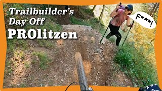
The PROlitzen Trail T34 is probably the most difficult lake.bike mountain bike trail!

SAFETY:

Similar to ski slopes and hiking trails, approved mountain bike trails and mountain bike single trails are also divided into different levels of difficulty. The gradient degree, possible dangers, but also the condition of the trails are decisive for the classification as very easy, easy, moderately difficult and difficult routes.

It is strongly recommended to start with the easiest level of difficulty and to inform yourself about each mountain bike trail in advance.

Riding the trail is only permitted with the necessary protective equipment (full-face helmet, goggles, gloves, protective vest, elbow pads, knee pads and suitable shoes) and a mountain bike (Enduro MTB or Dowhill MTB) appropriate for this kind of trail, including suitable attachments (downhill suspension fork and damper, suitable brakes, suitable geometry, downhill tires) !

The PROlitzen Trail is a black trail!

Black = difficult

For whom is this trail suitable and what riding technique is required? For trail experts only! Excellent mountain bike ability required: excellent balance, weight needs to be transferred to get past obstacles, steps and big drops on trail, safe cornering and braking ability, perfect switchback riding skills needed, trail ability, jumping and dropping skills and loads of trail experience!

Hazards: Drops from big heights into dangerous terrain possible with danger of falling and loss of life along the whole trail!

Trail properties: Partially very loose, very variable ground with constant roots and stones

Obstacles: very high drops and steps in quick succession. Drops cannot be rolled over and have a particularly high risk of falling!

Gradient: Extremely steep, average ≥ 20%; maximum ≥ 70%

Curves: extremely steep and tight curves and exits of curves

Trail width: extremely narrow: minimum 0.2 m.

Jumps: Cannot be ridden over or ridden around


SAFETY GEAR

Riding the trail is only permitted with the necessary protective equipment (full-face helmet, goggles, gloves, protective vest, elbow pads, knee pads and suitable shoes) and a mountain bike (Enduro MTB or Dowhill MTB) appropriate for this kind of trail, including suitable attachments (downhill suspension fork and damper, suitable brakes, suitable geometry, downhill tires)!

Also take a smarpthone with you so that you can make emergency phone calls, a first aid kit and enough drinking water. It is recommendable to ride this trail with a partner.

Access Info

1. Via gondola
2. via bike along the Transfer street

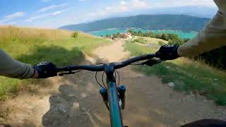
The "PROlitzen Trail T34" starts at the Kanzelhöhe / Gerlitzen Alp. From here you follow the course of the trail and the signs down to Annenheim. Our safety instructions must be observed at all time

Recent Activity on Trail

Past Week
  • 2 rides
  • 7 miles average
6 Months
  • 3 rides
  • 6 miles avg distance
All
  • 43 rides
  • Last: Jun 15, 2026
c1c2c3c4
January
February
March
April
May
June
July
August
September
October
November
December
update trails status or condition

PROlitzen Trail Trail Reports

statusdatedescription
May 29, 2026 @ 8:42pm (Europe/Vienna)
May 29, 2026
reporter Season start - 30.05.2026
Nov 2, 2025 @ 8:44pm (Europe/Vienna)
Nov 2, 2025
reporter Season ist over. See you in 2026.
Oct 4, 2025 @ 1:09pm (Europe/Ljubljana)
Oct 4, 2025
Aug 20, 2025 @ 9:51am
Aug 20, 2025
In good shape. A few of the berms are blown out, but otherwise, mint
Jun 23, 2025 @ 1:10pm
Jun 23, 2025
reporter open
more »
Status:
on May 29, 2026
Avg: 4.55 (16 votes)
Your vote: 0

view (203)
close
3D
Trail Conditions
  • Unknown
  • Snow Groomed
  • Snow Packed
  • Snow Covered
  • Snow Cover Partial
  • Freeze/thaw Cycle
  • Icy
  • Prevalent Mud
  • Wet
  • Variable
  • Ideal
  • Dry
  • Very Dry
Trail Flow (Ridden Direction)
Trailforks scans users ridelogs to determine the most popular direction each trail is ridden. A good flowing trail network will have most trails flowing in a single direction according to their intension.
The colour categories are based on what percentage of riders are riding a trail in its intended direction.
  • > 96%
  • > 90%
  • > 80%
  • > 70%
  • > 50%
  • < 50%
  • bi-directional trail
  • no data
Trail Last Ridden
Trailforks scans ridelogs to determine the last time a trail was ridden.
  • < 2 days
  • < 1 week
  • < 2 weeks
  • < 1 month
  • < 6 months
  • > 6 months
Trail Ridden Direction
The intended direction a trail should be ridden.
  • Downhill Only
  • Downhill Primary
  • Both Directions
  • Uphill Primary
  • Uphill Only
  • One Direction
Contribute Details
Colors indicate trail is missing specified detail.
  • Description
  • Photos
  • Description & Photos
  • Videos
Trail Popularity ?
Trailforks scans ridelogs to determine which trails are ridden the most in the last 9 months. Trails are compared with nearby trails in the same city region with a possible 25 colour shades. Think of this as a heatmap, more rides = more kinetic energy = warmer colors.
  • most popular
  • popular
  • less popular
  • not popular
ATV/ORV/OHV Filter
Max Vehicle Width
inches
US Cell Coverage
Legend
cell carrier legend

Radar Time
Activity Recordings
Trailforks uses anonymized public activity data. ?
Activity Recordings
Trailforks uses anonymized public activity data. ?
Personal Heatmap
Activity Types
all / none
Options
2
Date range month
Winter Trails
Warning A routing network for winter maps does not exist. Selecting trails using the winter trails layer has been disabled.
Missing Trails
Most Popular
Least Popular
Trails are colored based on popularity. The more popular a trail is, the more red. Less popular trails trend towards green.
Jump Magnitude Heatmap
Heatmap of where riders jump on trails. Zoom in to see individual jumps, click circles to view jump details.
BC Backroad Status

Service Road Atlas is a free to use, community-driven service for viewing and creating reports on the numerous back-country service roads around B.C. and Alberta.

map legend
Slope Aspect
Direction the slope faces
Flat N NE E SE S SW W NW
Trails Deemphasized
Trails are shown in grey.
disable
Only show trails with no bike usage.
Enable
Suggested Layers
Based on selected activity type

    Save the current map location and zoom level as your default home location whenever this page is loaded.

    Save
        Directions to prolitzen-trail trailhead (46.674820, 13.896970)

        Photos

        25 more »
        86 |
        Aug 7, 2024 @ 1:19am
        Aug 7, 2024
        86 |
        Aug 7, 2024 @ 1:19am
        Aug 7, 2024
        92 |
        Aug 7, 2024 @ 1:19am
        Aug 7, 2024
        95 |
        Aug 7, 2024 @ 1:19am
        Aug 7, 2024

        Videos

        4 more »
        PROlitzen Trail
        6:28 | 633 | Nov 17, 2022 , Villach
        Prolitzen Party Lap Preview: A Trailbuilders...
        15:44 | 296 | Oct 13, 2022 , Villach
        Der neue PROlitzen Trail mit Stevie Schneider ...
        10:26 | 710 | May 25, 2022 , Villach
        PROlitzen Trail Highlights
        0:29 | 164 | May 13, 2024 , Villach

        7 Reviews & Comments


        We hope you've been enjoying Trailforks!

        Create a FREE account to view trail comments and much more.

        • By lakebiketrailsTF Pro lakebike & contributors
        • #516464 - 3,513 views

        Frequently Asked Questions About PROlitzen Trail

        Where is PROlitzen Trail located?
        PROlitzen Trail is located in Trailcenter Ossiacher See, Villach, Austria. It is part of the Trailcenter Ossiacher See trail network. The trailhead is located at coordinates 46.67482, 13.89697.
        How hard is PROlitzen Trail?
        PROlitzen Trail is rated as Proline difficulty. The physical rating is Hard. The average grade is 24.8%.
        What is the elevation gain for PROlitzen Trail?
        PROlitzen Trail has 161 ft of elevation gain. The trail has 3,210 ft of elevation descent. The elevation ranges from 1,745 ft to 4,794 ft.
        Is PROlitzen Trail a point to point trail?
        Yes, PROlitzen Trail is a point to point trail. The direction is Downhill Only. The trail type is singletrack.

        Hit the Trail

        Open in App

        Get this trail on your phone instantly.
        open trail in app

        Download Trail

        Save to wishlist, Garmin & download.
        save the trail

        Find Related Routes

        Find routes and users activities that include this trail.
        find routes for this trail

        You must enter a description before submitting.