more stats
719 ft
Distance
-122 ft
Descent
00:00:58
Avg time
-122 ft
Altitude change
435 ft
Altitude min
557 ft
Altitude max
557 ft
Altitude start
436 ft
Altitude end
-17%
Grade
-27.1%
Grade max
-6.7%
Grade min
705 ft
Distance down
13 ft
Distance flat
00:00:58
Avg time

Prosperity Details

  • Activities
    • Mountain Bike
    • E-Bike
    • Hike
    • Trail Running
  • Riding Area
    Partridge Hills
    Victoria, British Columbia
  • Difficulty Rating
  • Local Popularity
    60 in Mountain Biking [+]
    • 70 in E-Biking
    • 60 in Trail Running
    • 65 in Hiking
  • Global Ranking
    #24535 in Mountain Biking [+]
    • #50136 in E-Biking
    • #94015 in Trail Running
    • #91861 in Hiking
  • Hiking SAC Scale
    T2 Mountain Hiking
  • Trail Type
    Singletrack
  • Bike Type
    AM
  • Direction
    Downhill Primary
    Popular Direction Shown
  • Trail Visibility
    Always easy to follow
  • Dogs Allowed
    Yes
  • eBike Allowed
    Yes up to Class 1
  • TTFs on Trail
    Berm, Drop, Rock Face, Rock Garden
  • Land Owner

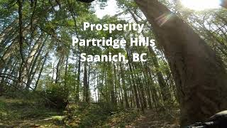
Prosperity/Last Car on the Ferry are typically ridden together, these are 2 of the most sustained downhills in the park with berms, rocks and small optional doubles. SIMBS in BC Parks are working to make a sanctioned entrance to this trail.

The original builder named this Last Car on the Ferry, but the order of the trails was flipped in the BC Parks map. To maintain consistency this trail should be named Prosperity.

Local Trail Association

Recent Activity on Trail

Past Week
  • 1 rides
  • 5 miles average
6 Months
  • 41 rides
  • 7 miles avg distance
All
  • 361 rides
  • Last: Jun 25, 2026
c1c2c3c4
January
February
March
April
May
June
July
August
September
October
November
December
Status:
on Oct 6, 2025
Ideal
Avg: 3.98 (1 votes)
Your vote: 0

view (1,988)
close
3D
Trail Conditions
  • Unknown
  • Snow Groomed
  • Snow Packed
  • Snow Covered
  • Snow Cover Partial
  • Freeze/thaw Cycle
  • Icy
  • Prevalent Mud
  • Wet
  • Variable
  • Ideal
  • Dry
  • Very Dry
Trail Flow (Ridden Direction)
Trailforks scans users ridelogs to determine the most popular direction each trail is ridden. A good flowing trail network will have most trails flowing in a single direction according to their intension.
The colour categories are based on what percentage of riders are riding a trail in its intended direction.
  • > 96%
  • > 90%
  • > 80%
  • > 70%
  • > 50%
  • < 50%
  • bi-directional trail
  • no data
Trail Last Ridden
Trailforks scans ridelogs to determine the last time a trail was ridden.
  • < 2 days
  • < 1 week
  • < 2 weeks
  • < 1 month
  • < 6 months
  • > 6 months
Trail Ridden Direction
The intended direction a trail should be ridden.
  • Downhill Only
  • Downhill Primary
  • Both Directions
  • Uphill Primary
  • Uphill Only
  • One Direction
Contribute Details
Colors indicate trail is missing specified detail.
  • Description
  • Photos
  • Description & Photos
  • Videos
Trail Popularity ?
Trailforks scans ridelogs to determine which trails are ridden the most in the last 9 months. Trails are compared with nearby trails in the same city region with a possible 25 colour shades. Think of this as a heatmap, more rides = more kinetic energy = warmer colors.
  • most popular
  • popular
  • less popular
  • not popular
ATV/ORV/OHV Filter
Max Vehicle Width
inches
US Cell Coverage
Legend
cell carrier legend

Radar Time
Activity Recordings
Trailforks uses anonymized public activity data. ?
Activity Recordings
Trailforks uses anonymized public activity data. ?
Personal Heatmap
Activity Types
all / none
Options
2
Date range month
Winter Trails
Warning A routing network for winter maps does not exist. Selecting trails using the winter trails layer has been disabled.
Missing Trails
Most Popular
Least Popular
Trails are colored based on popularity. The more popular a trail is, the more red. Less popular trails trend towards green.
Jump Magnitude Heatmap
Heatmap of where riders jump on trails. Zoom in to see individual jumps, click circles to view jump details.
BC Backroad Status

Service Road Atlas is a free to use, community-driven service for viewing and creating reports on the numerous back-country service roads around B.C. and Alberta.

map legend
Slope Aspect
Direction the slope faces
Flat N NE E SE S SW W NW
Trails Deemphasized
Trails are shown in grey.
disable
Only show trails with no bike usage.
Enable
Suggested Layers
Based on selected activity type

    Save the current map location and zoom level as your default home location whenever this page is loaded.

    Save
        Directions to prosperity-435849 trailhead (48.555630, -123.472630)

        Photos

        1 more »
        132 |
        Dec 17, 2023 @ 12:18pm
        Dec 17, 2023

        Videos

        1 more »
        Prosperity at Partridge Hills in Saanich, BC
        3:11 | 80 | May 2, 2024 , Victoria

        Routes with this trail

        15 miles 3,323 ft 33
        Course idea for an enduro

        2 Reviews & Comments


        We hope you've been enjoying Trailforks!

        Create a FREE account to view trail comments and much more.

        • By DubnykTF Pro TRAILFORKS & contributors
        • #435849 - 714 views

        Frequently Asked Questions About Prosperity

        Where is Prosperity located?
        Prosperity is located in Partridge Hills, Victoria, British Columbia, Canada. It is part of the Partridge Hills trail network. The trailhead is located at coordinates 48.55563, -123.47263.
        How hard is Prosperity?
        Prosperity is rated as Black Diamond difficulty. The average grade is 17%.
        What is the elevation gain for Prosperity?
        The trail has 122 ft of elevation descent. The elevation ranges from 435 ft to 557 ft.
        Is Prosperity a point to point trail?
        Prosperity is not a point to point trail. The direction is Downhill Primary. The trail type is singletrack.

        Hit the Trail

        Open in App

        Get this trail on your phone instantly.
        open trail in app

        Download Trail

        Save to wishlist, Garmin & download.
        save the trail

        Find Related Routes

        Find routes and users activities that include this trail.
        find routes for this trail

        You must enter a description before submitting.