more stats
2,894 ft
Distance
37 ft
Climb
-364 ft
Descent
00:05:29
Avg time
-328 ft
Altitude change
992 ft
Altitude min
1,338 ft
Altitude max
1,338 ft
Altitude start
1,010 ft
Altitude end
-11.3%
Grade
-49.6%
Grade max
16.8%
Grade min
446 ft
Distance climb
2,283 ft
Distance down
164 ft
Distance flat
00:05:29
Avg time

Psychopath Details

  • Activities
    • Mountain Bike
    • E-Bike
    • Hike
    • Trail Running
  • Riding Area
    Mackenzie
    Pemberton, British Columbia
  • Difficulty Rating
  • Local Popularity
    80 in Mountain Biking [+]
    • 85 in E-Biking
    • 5 in Trail Running
    • 5 in Hiking
  • Global Ranking
    #73438 in Mountain Biking [+]
    • #26020 in E-Biking
    • #101068 in Trail Running
    • #215913 in Hiking
  • Trail Type
    Singletrack
  • Dogs Allowed
    Yes
  • eBike Allowed
    Yes up to Class 1

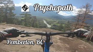
An old school trail that starts out with some cool rock rolls with a million dollar view then becomes a fast and fun track that ends at the McKenzie FSR on corner above the start of Wild Potato. If you haven't ridden it in a while, go check it out as it rides far better than it used to. Great way to start the day to get to the Wild Potato Climb or finish the day to get back to the parking lot

Access Info

Turn right about 100m into Blood, Sweat and Fear at the sign post

Local Trail Association
Traditionally Indigenous Territory

Recent Activity on Trail

Past Week
  • 0 rides
  •  
6 Months
  • 66 rides
  • 9 miles avg distance
All
  • 449 rides
  • Last: Apr 19, 2026
c1c2c3c4
January
February
March
April
May
June
July
August
September
October
November
December
Status:
on Jun 14, 2026
Very Dry
Avg: 3.77 (16 votes)
Your vote: 0

view (2,228)
close
3D
Trail Conditions
  • Unknown
  • Snow Groomed
  • Snow Packed
  • Snow Covered
  • Snow Cover Partial
  • Freeze/thaw Cycle
  • Icy
  • Prevalent Mud
  • Wet
  • Variable
  • Ideal
  • Dry
  • Very Dry
Trail Flow (Ridden Direction)
Trailforks scans users ridelogs to determine the most popular direction each trail is ridden. A good flowing trail network will have most trails flowing in a single direction according to their intension.
The colour categories are based on what percentage of riders are riding a trail in its intended direction.
  • > 96%
  • > 90%
  • > 80%
  • > 70%
  • > 50%
  • < 50%
  • bi-directional trail
  • no data
Trail Last Ridden
Trailforks scans ridelogs to determine the last time a trail was ridden.
  • < 2 days
  • < 1 week
  • < 2 weeks
  • < 1 month
  • < 6 months
  • > 6 months
Trail Ridden Direction
The intended direction a trail should be ridden.
  • Downhill Only
  • Downhill Primary
  • Both Directions
  • Uphill Primary
  • Uphill Only
  • One Direction
Contribute Details
Colors indicate trail is missing specified detail.
  • Description
  • Photos
  • Description & Photos
  • Videos
Trail Popularity ?
Trailforks scans ridelogs to determine which trails are ridden the most in the last 9 months. Trails are compared with nearby trails in the same city region with a possible 25 colour shades. Think of this as a heatmap, more rides = more kinetic energy = warmer colors.
  • most popular
  • popular
  • less popular
  • not popular
ATV/ORV/OHV Filter
Max Vehicle Width
inches
US Cell Coverage
Legend
cell carrier legend

Radar Time
Activity Recordings
Trailforks uses anonymized public activity data. ?
Activity Recordings
Trailforks uses anonymized public activity data. ?
Personal Heatmap
Activity Types
all / none
Options
2
Date range month
Winter Trails
Warning A routing network for winter maps does not exist. Selecting trails using the winter trails layer has been disabled.
Missing Trails
Most Popular
Least Popular
Trails are colored based on popularity. The more popular a trail is, the more red. Less popular trails trend towards green.
Jump Magnitude Heatmap
Heatmap of where riders jump on trails. Zoom in to see individual jumps, click circles to view jump details.
BC Backroad Status

Service Road Atlas is a free to use, community-driven service for viewing and creating reports on the numerous back-country service roads around B.C. and Alberta.

map legend
Slope Aspect
Direction the slope faces
Flat N NE E SE S SW W NW
Trails Deemphasized
Trails are shown in grey.
disable
Only show trails with no bike usage.
Enable
Suggested Layers
Based on selected activity type

    Save the current map location and zoom level as your default home location whenever this page is loaded.

    Save
        Directions to psychopath trailhead (50.331320, -122.770260)

        Photos

        9 more »
        70 |
        Mar 30, 2024 @ 6:28pm
        Mar 30, 2024
        167 |
        Jan 21, 2021 @ 11:55pm
        Jan 21, 2021
        406 |
        May 9, 2018 @ 7:20am
        May 9, 2018
        413 |
        May 9, 2018 @ 7:18am
        May 9, 2018

        Videos

        3 more »
        youtuber PSYCHOPATH | Black trail | Pemberton
        3:02 | 177 | Nov 28, 2023 , Pemberton
        Psychopath in Pemberton, BC
        4:50 | 107 | Feb 22, 2025 , Pemberton
        youtuber There's courage in numbers !? Dirt Surf A New One
        4:21 | 176 | Apr 19, 2023 , Pemberton

        Trail Lists

        Routes with this trail

        4.5 12 miles 3,157 ft 18 Loop
        This is a fun loop and a longer ride for Advanced riders, featuring some larger features and climbs. Begin...
        5.0 6 miles 1,316 ft 8 Race
        Starting Mckenzie Carpark Ride along the FSR to Happy trail, climbing up to Waco Connector via Shama....
        10 miles 3,376 ft 5
        Just trying to have fun please

        Trail Products

        3 Reviews & Comments


        We hope you've been enjoying Trailforks!

        Create a FREE account to view trail comments and much more.

        Frequently Asked Questions About Psychopath

        Where is Psychopath located?
        Psychopath is located in Mackenzie, Pemberton, British Columbia, Canada. It is part of the Mackenzie trail network. The trailhead is located at coordinates 50.33132, -122.77026.
        How hard is Psychopath?
        Psychopath is rated as Black Diamond difficulty. The average grade is 11.3%.
        What is the elevation gain for Psychopath?
        Psychopath has 37 ft of elevation gain. The trail has 364 ft of elevation descent. The elevation ranges from 992 ft to 1,338 ft.
        How long is Psychopath?
        Psychopath is 2,894 ft long. The trail type is singletrack.

        Hit the Trail

        Open in App

        Get this trail on your phone instantly.
        open trail in app

        Download Trail

        Save to wishlist, Garmin & download.
        save the trail

        Find Related Routes

        Find routes and users activities that include this trail.
        find routes for this trail

        You must enter a description before submitting.