more stats
1.4 miles
Distance
200 ft
Climb
-197 ft
Descent
00:07:24
Avg time
4 ft
Altitude change
612 ft
Altitude min
813 ft
Altitude max
809 ft
Altitude start
814 ft
Altitude end
0.1%
Grade
-13%
Grade max
15.7%
Grade min
3,169 ft
Distance climb
3,566 ft
Distance down
535 ft
Distance flat
00:07:24
Avg time

Queen Bee Details

  • Activities
    • Mountain Bike
    • Hike
    • Trail Running
  • Riding Area
    Hillside Park
    Anchorage, Alaska
  • Difficulty Rating
  • Local Popularity
    75 in Mountain Biking [+]
    • 90 in Trail Running
    • 85 in Hiking
  • Global Ranking
    #40869 in Mountain Biking [+]
    • #28413 in Trail Running
    • #83306 in Hiking
  • Trail Type
    Singletrack
  • Climb Difficulty
    Blue
  • Physical Rating
    Moderate
  • Season
    MAY - OCT
  • Dogs Allowed
    Yes
  • TTFs on Trail
    Berm, Jump
  • Year Opened
    2008

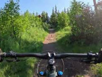
Queen Bee is a great trail on hillside with a good combination of flow and flat turns to keep you on your toes as well as a couple of rock rides to spice up the flatter sections. It is best thought of as Queen Bee north and Queen Bee south when describing to friends where you are or enjoying connecting it to Drone Lane and Janices Jive and the Hive. The trail is multi directional so watch your speed on those blind corners.
Trail can be used in the winter when the snow is good and makes a great connector up to ride middlefork loop. Please stay off the trail during breakup so we don't trash it before the endless summer riding.

Local Trail Association
Traditionally Indigenous Territory

Recent Activity on Trail

Past Week
  • 3 rides
  • 8 miles average
6 Months
  • 25 rides
  • 12 miles avg distance
All
  • 497 rides
  • Last: Jun 11, 2026
c1c2c3c4
January
February
March
April
May
June
July
August
September
October
November
December
update trails status or condition

Queen Bee Trail Reports

statusdatedescription
Jun 14, 2026 @ 10:50am (America/Anchorage)
Jun 14, 2026
May 21, 2026 @ 12:59pm (America/Anchorage)
May 21, 2026
May 25, 2024 @ 3:42am
May 25, 2024
Some avoidable mud
May 20, 2024 @ 6:26pm
May 20, 2024
Hillside trails are open except lower Whoop Whoop.
May 9, 2024 @ 2:35pm
May 9, 2024
Please stay off trail until it dries. STA will post when trail is open. Thank You. STA Trail Manager.
more »
Status:
on Jun 14, 2026
Dry
Avg: 3.99 (6 votes)
Your vote: 0

view (2,539)
close
3D
Trail Conditions
  • Unknown
  • Snow Groomed
  • Snow Packed
  • Snow Covered
  • Snow Cover Partial
  • Freeze/thaw Cycle
  • Icy
  • Prevalent Mud
  • Wet
  • Variable
  • Ideal
  • Dry
  • Very Dry
Trail Flow (Ridden Direction)
Trailforks scans users ridelogs to determine the most popular direction each trail is ridden. A good flowing trail network will have most trails flowing in a single direction according to their intension.
The colour categories are based on what percentage of riders are riding a trail in its intended direction.
  • > 96%
  • > 90%
  • > 80%
  • > 70%
  • > 50%
  • < 50%
  • bi-directional trail
  • no data
Trail Last Ridden
Trailforks scans ridelogs to determine the last time a trail was ridden.
  • < 2 days
  • < 1 week
  • < 2 weeks
  • < 1 month
  • < 6 months
  • > 6 months
Trail Ridden Direction
The intended direction a trail should be ridden.
  • Downhill Only
  • Downhill Primary
  • Both Directions
  • Uphill Primary
  • Uphill Only
  • One Direction
Contribute Details
Colors indicate trail is missing specified detail.
  • Description
  • Photos
  • Description & Photos
  • Videos
Trail Popularity ?
Trailforks scans ridelogs to determine which trails are ridden the most in the last 9 months. Trails are compared with nearby trails in the same city region with a possible 25 colour shades. Think of this as a heatmap, more rides = more kinetic energy = warmer colors.
  • most popular
  • popular
  • less popular
  • not popular
ATV/ORV/OHV Filter
Max Vehicle Width
inches
US Cell Coverage
Legend
cell carrier legend

Radar Time
Activity Recordings
Trailforks uses anonymized public activity data. ?
Activity Recordings
Trailforks uses anonymized public activity data. ?
Personal Heatmap
Activity Types
all / none
Options
2
Date range month
Winter Trails
Warning A routing network for winter maps does not exist. Selecting trails using the winter trails layer has been disabled.
Missing Trails
Most Popular
Least Popular
Trails are colored based on popularity. The more popular a trail is, the more red. Less popular trails trend towards green.
Jump Magnitude Heatmap
Heatmap of where riders jump on trails. Zoom in to see individual jumps, click circles to view jump details.
BC Backroad Status

Service Road Atlas is a free to use, community-driven service for viewing and creating reports on the numerous back-country service roads around B.C. and Alberta.

map legend
Slope Aspect
Direction the slope faces
Flat N NE E SE S SW W NW
Trails Deemphasized
Trails are shown in grey.
disable
Only show trails with no bike usage.
Enable
Suggested Layers
Based on selected activity type

    Save the current map location and zoom level as your default home location whenever this page is loaded.

    Save
        Directions to queen-bee trailhead (61.138770, -149.728180)

        Photos

        11 more »
        71 |
        Jul 28, 2023 @ 10:46pm
        Jul 28, 2023
        72 |
        Jul 27, 2023 @ 7:18pm
        Jul 27, 2023
        74 |
        Jul 27, 2023 @ 7:17pm
        Jul 27, 2023
        64 |
        Jul 27, 2023 @ 7:17pm
        Jul 27, 2023

        Videos

        1 more »
        From Drone Ln to Queen Bee
        82 | Jun 13, 2025 , Anchorage

        Trail Lists

        Routes with this trail

        5.0 1 mile 487 ft 3 Out & Back
        Short way to the top of the STA trails at hillside
        7 miles 1,067 ft 13 Loop
        A fun 7 mile loop that integrates the fun downhill of and with some fun winding climbs.
        6 miles 796 ft 18 Loop
        Nice quick Hillside route that maximizes descent for your climb. There's still the long climb up Queen Bee...

        1 Review & Comments


        We hope you've been enjoying Trailforks!

        Create a FREE account to view trail comments and much more.

        Frequently Asked Questions About Queen Bee

        Where is Queen Bee located?
        Queen Bee is located in Hillside Park, Anchorage, Alaska, United States. It is part of the Hillside Park trail network. The trailhead is located at coordinates 61.13877, -149.72818.
        How hard is Queen Bee?
        Queen Bee is rated as Green difficulty. The physical rating is Moderate. The average grade is 0.1%. The climb difficulty is rated Blue.
        What is the elevation gain for Queen Bee?
        Queen Bee has 200 ft of elevation gain. The trail has 197 ft of elevation descent. The elevation ranges from 612 ft to 813 ft.
        How long is Queen Bee?
        Queen Bee is 1.4 miles long. The trail type is singletrack.

        Hit the Trail

        Open in App

        Get this trail on your phone instantly.
        open trail in app

        Download Trail

        Save to wishlist, Garmin & download.
        save the trail

        Find Related Routes

        Find routes and users activities that include this trail.
        find routes for this trail

        You must enter a description before submitting.