more stats
2.8 miles
Distance
-1,420 ft
Descent
00:20:05
Avg time
-1,420 ft
Altitude change
7,397 ft
Altitude min
8,816 ft
Altitude max
8,816 ft
Altitude start
7,398 ft
Altitude end
-9.5%
Grade
-44.6%
Grade max
6.8%
Grade min
49 ft
Distance climb
3 miles
Distance down
00:20:05
Avg time

Quemazon Trail Details

  • Activities
    • Mountain Bike
    • Hike
    • Trail Running
  • Riding Area
    Los Alamos
    , New Mexico
  • Difficulty Rating
  • Local Popularity
    85 in Mountain Biking [+]
    • 85 in Trail Running
    • 85 in Hiking
  • Global Ranking
    #54844 in Mountain Biking [+]
    • #57594 in Trail Running
    • #59219 in Hiking
  • Hiking SAC Scale
    T2 Mountain Hiking
  • Trail Type
    Singletrack
  • Bike Type
    AM
  • Direction
    Both Directions
  • Climb Difficulty
    Black Diamond
  • Physical Rating
    Hard
  • Trail Visibility
    Always easy to follow
  • Season
    April-November
  • Dogs Allowed
    Yes
  • TTFs on Trail
    Drop, Roller Coaster
  • Ride in Rain
    Yes

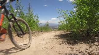
Usually done as an out and back but can be looped with Pipeline road to town, Pajarito ski area, or Guaje Ridge Trail. Very steep climb on volcanic tuff rock, a lot like riding slick rock. Descent is fast and fun, like a roller coaster ride.

Access Info

West on Trinity Drive for 0.6 miles past Diamond Drive. Turn left twice and follow Quemazon Trail road to a small parking area at the trailhead.

Trail Supporters

  • USFS
    Land Manager
Local Trail Association
Traditionally Indigenous Territory

Recent Activity on Trail

Past Week
  • 0 rides
  •  
6 Months
  • 13 rides
  • 9 miles avg distance
All
  • 104 rides
  • Last: Jun 13, 2026
c1c2c3c4
January
February
March
April
May
June
July
August
September
October
November
December
update trails status or condition

Quemazon Trail Trail Reports

statusdatedescription
Jun 4, 2026 @ 12:20pm (America/Denver)
Jun 4, 2026
Dec 31, 2025 @ 9:14pm (America/Denver)
Dec 31, 2025
In great shape as of 12/31/25. Dang, we really need snow!
Nov 2, 2025 @ 7:45pm (America/Denver)
Nov 2, 2025
Rain has just wrecked the upper 1/3 of the trail this summer, it's nigh-unrideable. If you mostly enjoy the slabs, just turn around at the second...
Jan 25, 2025 @ 8:42pm
Jan 25, 2025
Partial snow cover but mostly powder. No ice or mud. Certainly rideable without damaging trail.
Jan 25, 2025 @ 8:40pm
Jan 25, 2025
Partial snow cover but mostly powder. No ice or mud. Certainly rideable.
more »
Status:
on Jun 4, 2026
Ideal
Avg: 4.24 (6 votes)
Your vote: 0

view (527)
close
3D
Trail Conditions
  • Unknown
  • Snow Groomed
  • Snow Packed
  • Snow Covered
  • Snow Cover Partial
  • Freeze/thaw Cycle
  • Icy
  • Prevalent Mud
  • Wet
  • Variable
  • Ideal
  • Dry
  • Very Dry
Trail Flow (Ridden Direction)
Trailforks scans users ridelogs to determine the most popular direction each trail is ridden. A good flowing trail network will have most trails flowing in a single direction according to their intension.
The colour categories are based on what percentage of riders are riding a trail in its intended direction.
  • > 96%
  • > 90%
  • > 80%
  • > 70%
  • > 50%
  • < 50%
  • bi-directional trail
  • no data
Trail Last Ridden
Trailforks scans ridelogs to determine the last time a trail was ridden.
  • < 2 days
  • < 1 week
  • < 2 weeks
  • < 1 month
  • < 6 months
  • > 6 months
Trail Ridden Direction
The intended direction a trail should be ridden.
  • Downhill Only
  • Downhill Primary
  • Both Directions
  • Uphill Primary
  • Uphill Only
  • One Direction
Contribute Details
Colors indicate trail is missing specified detail.
  • Description
  • Photos
  • Description & Photos
  • Videos
Trail Popularity ?
Trailforks scans ridelogs to determine which trails are ridden the most in the last 9 months. Trails are compared with nearby trails in the same city region with a possible 25 colour shades. Think of this as a heatmap, more rides = more kinetic energy = warmer colors.
  • most popular
  • popular
  • less popular
  • not popular
ATV/ORV/OHV Filter
Max Vehicle Width
inches
US Cell Coverage
Legend
cell carrier legend

Radar Time
Activity Recordings
Trailforks uses anonymized public activity data. ?
Activity Recordings
Trailforks uses anonymized public activity data. ?
Personal Heatmap
Activity Types
all / none
Options
2
Date range month
Winter Trails
Warning A routing network for winter maps does not exist. Selecting trails using the winter trails layer has been disabled.
Missing Trails
Most Popular
Least Popular
Trails are colored based on popularity. The more popular a trail is, the more red. Less popular trails trend towards green.
Jump Magnitude Heatmap
Heatmap of where riders jump on trails. Zoom in to see individual jumps, click circles to view jump details.
BC Backroad Status

Service Road Atlas is a free to use, community-driven service for viewing and creating reports on the numerous back-country service roads around B.C. and Alberta.

map legend
Slope Aspect
Direction the slope faces
Flat N NE E SE S SW W NW
Trails Deemphasized
Trails are shown in grey.
disable
Only show trails with no bike usage.
Enable
Suggested Layers
Based on selected activity type

    Save the current map location and zoom level as your default home location whenever this page is loaded.

    Save
        Directions to quemazon-trail trailhead (35.899620, -106.363270)

        Photos

        1 more »
        343 |
        May 16, 2017 @ 12:28am
        May 16, 2017

        Videos

        3 more »
        Quemazon Trail, NM
        3:08 | 408 | Jun 17, 2021 , Los Alamos
        GravityWorx product test down Quemazon
        0:00 | 157 | Mar 26, 2018 , Los Alamos
        Chasing my Shadow on a Giant Reign
        7:14 | 99 | Apr 12, 2016 , Los Alamos

        2 Reviews & Comments


        We hope you've been enjoying Trailforks!

        Create a FREE account to view trail comments and much more.

        • By nealpedersonTF Pro LATR & contributors
        • #16988 - 4,268 views

        Frequently Asked Questions About Quemazon Trail

        Where is Quemazon Trail located?
        Quemazon Trail is located in Los Alamos, New Mexico, United States. It is part of the Los Alamos trail network. The trailhead is located at coordinates 35.89962, -106.36327.
        How hard is Quemazon Trail?
        Quemazon Trail is rated as Black Diamond difficulty. The physical rating is Hard. The average grade is 9.5%. The climb difficulty is rated Black Diamond.
        What is the elevation gain for Quemazon Trail?
        The trail has 1,420 ft of elevation descent. The elevation ranges from 7,397 ft to 8,816 ft.
        Is Quemazon Trail a point to point trail?
        Quemazon Trail is not a point to point trail. The direction is Both Directions. The trail type is singletrack.

        Hit the Trail

        Open in App

        Get this trail on your phone instantly.
        open trail in app

        Download Trail

        Save to wishlist, Garmin & download.
        save the trail

        Find Related Routes

        Find routes and users activities that include this trail.
        find routes for this trail

        You must enter a description before submitting.