more stats
3,238 ft
Distance
-607 ft
Descent
00:06:21
Avg time
-607 ft
Altitude change
498 ft
Altitude min
1,105 ft
Altitude max
1,105 ft
Altitude start
499 ft
Altitude end
-18.7%
Grade
-39.5%
Grade max
-6.4%
Grade min
3,238 ft
Distance down
00:06:21
Avg time

Quick-E Details

  • Activities
    • Mountain Bike
    • E-Bike
  • Riding Area
    Mt. Mahony
    Powell River, British Columbia
  • Difficulty Rating
  • Voted Difficulty
    Black Diamond (2 votes)
  • Local Popularity
    95 in Mountain Biking [+]
    • 100 in E-Biking
  • Global Ranking
    #42844 in Mountain Biking [+]
    • #4661 in E-Biking
  • Trail Type
    Singletrack
  • Bike Type
    DH
  • Direction
    Downhill Primary
    Popular Direction Shown
  • Physical Rating
    Moderate
  • Dogs Allowed
    Yes
  • eBike Allowed
    Yes up to Class 1
  • TTFs on Trail
    Berm, Drop, Jump, Gap Jump

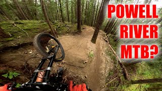
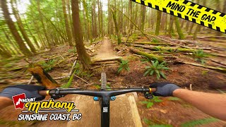
One of the original Mahony trails. This trail started as an old-school DH singletrack and has evolved into a fast multidimensional mountain bike trail thanks to some dedicated builders. The trail starts with some small doubles that lead you into a section of fast and technical flow. Nearing the middle of the trail three large optional features should be inspected before riding, two large gap jumps, and an intimidating wooden drop. The lower section of this trail is a work of art with the best dirt on Mahony. Flowing fast corners and more doubles. If you can link up all the features this is one of the best mountain bike trails in the province.

Nothing will catch you off guard, and if you are into keeping your wheel on the ground you will still have a great time with the sweet corners and epic green room feel.

Trail Supporters
  • Sponsor
Local Trail Association
Traditionally Indigenous Territory

Recent Activity on Trail

Past Week
  • 0 rides
  •  
6 Months
  • 24 rides
  • 20.6 km avg distance
All
  • 306 rides
  • Last: Jun 18, 2026
c1c2c3c4
January
February
March
April
May
June
July
August
September
October
November
December
update trails status or condition

Quick-E Trail Reports

statusdatedescription
May 6, 2026 @ 8:38pm (America/Vancouver)
May 6, 2026
trail is open, dry but still loads of fun
Apr 10, 2026 @ 6:48pm (America/Vancouver)
Apr 10, 2026
Closed for the past couple days, assume because too dry.
Jun 7, 2025 @ 4:16pm
Jun 7, 2025
May 2, 2025 @ 1:27pm
May 2, 2025
Dec 8, 2024 @ 3:05pm
Dec 8, 2024
Pretty great shape but some wet middle spots and one muck chunk in top 1/2. But overall in good shape.
more »
Status:
on May 6, 2026
Dry
Avg: 4.35 (15 votes)
Your vote: 0

view (2,283)
close
3D
Trail Conditions
  • Unknown
  • Snow Groomed
  • Snow Packed
  • Snow Covered
  • Snow Cover Partial
  • Freeze/thaw Cycle
  • Icy
  • Prevalent Mud
  • Wet
  • Variable
  • Ideal
  • Dry
  • Very Dry
Trail Flow (Ridden Direction)
Trailforks scans users ridelogs to determine the most popular direction each trail is ridden. A good flowing trail network will have most trails flowing in a single direction according to their intension.
The colour categories are based on what percentage of riders are riding a trail in its intended direction.
  • > 96%
  • > 90%
  • > 80%
  • > 70%
  • > 50%
  • < 50%
  • bi-directional trail
  • no data
Trail Last Ridden
Trailforks scans ridelogs to determine the last time a trail was ridden.
  • < 2 days
  • < 1 week
  • < 2 weeks
  • < 1 month
  • < 6 months
  • > 6 months
Trail Ridden Direction
The intended direction a trail should be ridden.
  • Downhill Only
  • Downhill Primary
  • Both Directions
  • Uphill Primary
  • Uphill Only
  • One Direction
Contribute Details
Colors indicate trail is missing specified detail.
  • Description
  • Photos
  • Description & Photos
  • Videos
Trail Popularity ?
Trailforks scans ridelogs to determine which trails are ridden the most in the last 9 months. Trails are compared with nearby trails in the same city region with a possible 25 colour shades. Think of this as a heatmap, more rides = more kinetic energy = warmer colors.
  • most popular
  • popular
  • less popular
  • not popular
ATV/ORV/OHV Filter
Max Vehicle Width
inches
US Cell Coverage
Legend
cell carrier legend

Radar Time
Activity Recordings
Trailforks uses anonymized public activity data. ?
Activity Recordings
Trailforks uses anonymized public activity data. ?
Personal Heatmap
Activity Types
all / none
Options
2
Date range month
Winter Trails
Warning A routing network for winter maps does not exist. Selecting trails using the winter trails layer has been disabled.
Missing Trails
Most Popular
Least Popular
Trails are colored based on popularity. The more popular a trail is, the more red. Less popular trails trend towards green.
Jump Magnitude Heatmap
Heatmap of where riders jump on trails. Zoom in to see individual jumps, click circles to view jump details.
BC Backroad Status

Service Road Atlas is a free to use, community-driven service for viewing and creating reports on the numerous back-country service roads around B.C. and Alberta.

map legend
Slope Aspect
Direction the slope faces
Flat N NE E SE S SW W NW
Trails Deemphasized
Trails are shown in grey.
disable
Only show trails with no bike usage.
Enable
Suggested Layers
Based on selected activity type

    Save the current map location and zoom level as your default home location whenever this page is loaded.

    Save
        Directions to quicke trailhead (49.912480, -124.469400)

        Photos

        21 more »
        115 |
        Oct 1, 2024 @ 9:10pm
        Oct 1, 2024
        108 |
        Oct 1, 2024 @ 9:10pm
        Oct 1, 2024
        100 |
        Oct 1, 2024 @ 9:10pm
        Oct 1, 2024
        117 |
        Oct 1, 2024 @ 9:09pm
        Oct 1, 2024

        Videos

        5 more »
        Yeah this place is the best. Mountain bike...
        23:09 | 93 | Nov 29, 2025 , Powell River
        POWELL RIVER MTB?
        8:27 | 234 | May 27, 2025 , Powell River
        Sunshine, in the Bag: Sampling some of the...
        14:20 | 166 | Jan 1, 2025 , Powell River
        youtuber QUICK-E | Powell River
        2:22 | 190 | Oct 1, 2024 , Powell River

        Routes with this trail

        3.0 7 miles 1,788 ft 2
        Push up. Enjoy the Down. Burley AND makes you go up the climb twice but it is sooo worth it.
        4.0 17 miles 4,189 ft 14 Loop Race
        5 Categories: Expert, JR Expert (Under 19) and Masters (40+) will all do the Long Course (5 Stages) Sport...
        17 miles 4,189 ft 14 Loop Race
        5 Categories: Expert, JR Expert (Under 19) and Masters (40+) will all do the Long Course (5 Stages) Sport...

        7 Reviews & Comments


        We hope you've been enjoying Trailforks!

        Create a FREE account to view trail comments and much more.

        • By tybouTF Pro QRCA & contributors
        • #267775 - 3,021 views

        Frequently Asked Questions About Quick-E

        Where is Quick-E located?
        Quick-E is located in Mt. Mahony, Powell River, British Columbia, Canada. It is part of the Mt. Mahony trail network. The trailhead is located at coordinates 49.91248, -124.4694.
        How hard is Quick-E?
        Quick-E is rated as Black Diamond difficulty. The physical rating is Moderate. The average grade is 18.7%.
        What is the elevation gain for Quick-E?
        The trail has 607 ft of elevation descent. The elevation ranges from 498 ft to 1,105 ft.
        Is Quick-E a point to point trail?
        Quick-E is not a point to point trail. The direction is Downhill Primary. The trail type is singletrack.

        Hit the Trail

        Open in App

        Get this trail on your phone instantly.
        open trail in app

        Download Trail

        Save to wishlist, Garmin & download.
        save the trail

        Find Related Routes

        Find routes and users activities that include this trail.
        find routes for this trail

        You must enter a description before submitting.