more stats
4.4 miles
Distance
1,327 ft
Climb
-64 ft
Descent
01:49:32
Avg time
1,261 ft
Altitude change
1,902 ft
Altitude min
3,191 ft
Altitude max
1,902 ft
Altitude start
3,163 ft
Altitude end
5.5%
Grade
-14.8%
Grade max
45.6%
Grade min
4 miles
Distance climb
1,716 ft
Distance down
121 ft
Distance flat
01:49:32
Avg time

Rabbit Lake Details

  • Activities
    • Mountain Bike
    • Gravel Bike
    • Hike
    • Trail Running
    • Snowshoe
    • Backcountry Ski
  • Riding Area
    Chugach State Park
    Anchorage, Alaska
  • Difficulty Rating
  • Local Popularity
    55 in Mountain Biking [+]
    • 5 in Trail Running
    • 85 in Hiking
    • 5 in Snowshoeing
    • 5 in Backcountry Skiing
  • Global Ranking
    #55200 in Mountain Biking [+]
    • #89241 in Trail Running
    • #3854 in Hiking
  • Trail Type
    Singletrack
  • Bike Type
    AM, XC, Gravel
  • Direction
    Both Directions
  • Climb Difficulty
    Blue
  • Physical Rating
    Moderate
  • Season
    MAY - OCT
  • Dogs Allowed
    Yes

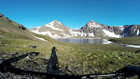
The route to Rabbit Lake is a long, moderate climb up an old road bed that eventually turns to singletrack. Your reward for the long climb is that the trail ends at a gorgeous alpine lake. The area is popular in the summer with hikers and skiers in the winter, so you'll likely not be the only one on the trail.

Disclaimer

Biking is prohibited on the McHugh Creek Trail after mile 4.4 at Rabbit Lake.

Local Trail Association
Traditionally Indigenous Territory

Recent Activity on Trail

Past Week
  • 0 rides
  •  
6 Months
  • 0 rides
  •  
All
  • 32 rides
  • Last: Nov 2, 2025
c1c2c3c4
January
February
March
April
May
June
July
August
September
October
November
December
update trails status or condition

Rabbit Lake Trail Reports

statusdatedescription
Aug 3, 2025 @ 1:56pm
Aug 3, 2025
Jul 4, 2025 @ 2:32pm
Jul 4, 2025
Jun 11, 2024 @ 1:15am
Jun 11, 2024
Still snow covered in places. Able to walk the snow fields and bike the other 90%
Nov 12, 2023 @ 12:19am
Nov 12, 2023
New snow, requires update
Sep 9, 2023 @ 10:19pm
Sep 9, 2023
more »
Status:
on Aug 3, 2025
Ideal
Avg: 3.98 (1 votes)
Your vote: 0

view (290)
close
3D
Trail Conditions
  • Unknown
  • Snow Groomed
  • Snow Packed
  • Snow Covered
  • Snow Cover Partial
  • Freeze/thaw Cycle
  • Icy
  • Prevalent Mud
  • Wet
  • Variable
  • Ideal
  • Dry
  • Very Dry
Trail Flow (Ridden Direction)
Trailforks scans users ridelogs to determine the most popular direction each trail is ridden. A good flowing trail network will have most trails flowing in a single direction according to their intension.
The colour categories are based on what percentage of riders are riding a trail in its intended direction.
  • > 96%
  • > 90%
  • > 80%
  • > 70%
  • > 50%
  • < 50%
  • bi-directional trail
  • no data
Trail Last Ridden
Trailforks scans ridelogs to determine the last time a trail was ridden.
  • < 2 days
  • < 1 week
  • < 2 weeks
  • < 1 month
  • < 6 months
  • > 6 months
Trail Ridden Direction
The intended direction a trail should be ridden.
  • Downhill Only
  • Downhill Primary
  • Both Directions
  • Uphill Primary
  • Uphill Only
  • One Direction
Contribute Details
Colors indicate trail is missing specified detail.
  • Description
  • Photos
  • Description & Photos
  • Videos
Trail Popularity ?
Trailforks scans ridelogs to determine which trails are ridden the most in the last 9 months. Trails are compared with nearby trails in the same city region with a possible 25 colour shades. Think of this as a heatmap, more rides = more kinetic energy = warmer colors.
  • most popular
  • popular
  • less popular
  • not popular
ATV/ORV/OHV Filter
Max Vehicle Width
inches
US Cell Coverage
Legend
cell carrier legend

Radar Time
Activity Recordings
Trailforks uses anonymized public activity data. ?
Activity Recordings
Trailforks uses anonymized public activity data. ?
Personal Heatmap
Activity Types
all / none
Options
2
Date range month
Winter Trails
Warning A routing network for winter maps does not exist. Selecting trails using the winter trails layer has been disabled.
Missing Trails
Most Popular
Least Popular
Trails are colored based on popularity. The more popular a trail is, the more red. Less popular trails trend towards green.
Jump Magnitude Heatmap
Heatmap of where riders jump on trails. Zoom in to see individual jumps, click circles to view jump details.
BC Backroad Status

Service Road Atlas is a free to use, community-driven service for viewing and creating reports on the numerous back-country service roads around B.C. and Alberta.

map legend
Slope Aspect
Direction the slope faces
Flat N NE E SE S SW W NW
Trails Deemphasized
Trails are shown in grey.
disable
Only show trails with no bike usage.
Enable
Suggested Layers
Based on selected activity type

    Save the current map location and zoom level as your default home location whenever this page is loaded.

    Save
        Directions to rabbit-lake trailhead (61.082390, -149.682320)

        Photos

        33 more »
        107 |
        Aug 9, 2021 @ 1:00am
        Aug 9, 2021
        108 |
        Jul 23, 2020 @ 10:37pm
        Jul 23, 2020
        113 |
        Jul 23, 2020 @ 10:36pm
        Jul 23, 2020
        108 |
        Jul 23, 2020 @ 10:36pm
        Jul 23, 2020

        Videos

        1 more »
        Rabbit Lakes
        0:57 | 1019 | Jun 23, 2016 , Anchorage

        Routes with this trail

        33 miles 14,178 ft 5 Point to Point
        traverse Penguin, Birdcreek, Indian, Falls Creek, Glen Alps

        1 Review & Comments


        We hope you've been enjoying Trailforks!

        Create a FREE account to view trail comments and much more.

        Frequently Asked Questions About Rabbit Lake

        Where is Rabbit Lake located?
        Rabbit Lake is located in Chugach State Park, Anchorage, Alaska, United States. It is part of the Chugach State Park trail network. The trailhead is located at coordinates 61.08239, -149.68232.
        What is the elevation gain for Rabbit Lake?
        Rabbit Lake has 1,327 ft of elevation gain. The trail has 64 ft of elevation descent. The elevation ranges from 1,902 ft to 3,191 ft.
        Is Rabbit Lake a point to point trail?
        Rabbit Lake is not a point to point trail. The direction is Both Directions. The trail type is singletrack.
        How long is Rabbit Lake?
        Rabbit Lake is 4.4 miles long. The trail type is singletrack.

        Hit the Trail

        Open in App

        Get this trail on your phone instantly.
        open trail in app

        Download Trail

        Save to wishlist, Garmin & download.
        save the trail

        Find Related Routes

        Find routes and users activities that include this trail.
        find routes for this trail

        You must enter a description before submitting.