more stats
1.1 miles
Distance
-1,389 ft
Descent
3,474 ft
High Point
-1,390 ft
Altitude change
2,084 ft
Altitude min
3,474 ft
Altitude start
2,083 ft
Altitude end
-23.4%
Grade
-58.5%
Grade max
-1%
Grade min
1 mile
Distance down
69 ft
Distance flat

Raciczka Details

  • Activities
    • Mountain Bike
    • E-Bike
  • Riding Area
  • Difficulty Rating
  • Voted Difficulty
    Black (2 votes)
  • Local Popularity
    85 in Mountain Biking [+]
    • 65 in E-Biking
  • Global Ranking
    #3997 in Mountain Biking [+]
    • #55557 in E-Biking
  • Trail Type
    Singletrack
  • Bike Type
    DH, AM
  • Trail Visibility
    Sometimes hard to follow
  • eBike Allowed
    Yes up to Class 1
  • TTFs on Trail
    Rock Garden

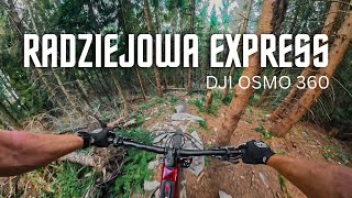
Raciczka to ścieżka, która odebrała Perci Sosnowskiego miano najtrudniejszego singla w Beskidzie Sądeckim. Jest stromo, jest ekspozycja, są duże i długie rockgardeny. W wielu miejscach trzeba uważać żeby nie spaść w dół po bardzo ostro nachylonym zboczu - właśnie z tego powodu trasa wyceniona jest na podwójny czarny diament.

This trail is unsanctioned.

Recent Activity on Trail

Past Week
  • 0 rides
  •  
6 Months
  • 4 rides
  • 16 miles avg distance
All
  • 19 rides
  • Last: Jun 9, 2026
c1c2c3c4
January
February
March
April
May
June
July
August
September
October
November
December
update trails status or condition

Raciczka Trail Reports

statusdatedescription
Mar 15, 2026 @ 10:09pm (Europe/Warsaw)
Mar 15, 2026
Ścieżka uprzątnięta i przejezdna.
Aug 2, 2025 @ 6:17pm
Aug 2, 2025
Jun 15, 2025 @ 6:32am
Jun 15, 2025
Jun 15, 2025 @ 6:31am
Jun 15, 2025
Obecnie przejezdna trasa, w jednym miejscu na grani dziki trochę ryły, albo ktoś zarył
Apr 19, 2025 @ 1:38pm
Apr 19, 2025
Ścieżka uprzątnięta i przejezdna w 100%. Warunki wręcz idealne.
more »
Status:
on Mar 22, 2026
Avg: 4.32 (3 votes)
Your vote: 0

view (140)
close
3D
Trail Conditions
  • Unknown
  • Snow Groomed
  • Snow Packed
  • Snow Covered
  • Snow Cover Partial
  • Freeze/thaw Cycle
  • Icy
  • Prevalent Mud
  • Wet
  • Variable
  • Ideal
  • Dry
  • Very Dry
Trail Flow (Ridden Direction)
Trailforks scans users ridelogs to determine the most popular direction each trail is ridden. A good flowing trail network will have most trails flowing in a single direction according to their intension.
The colour categories are based on what percentage of riders are riding a trail in its intended direction.
  • > 96%
  • > 90%
  • > 80%
  • > 70%
  • > 50%
  • < 50%
  • bi-directional trail
  • no data
Trail Last Ridden
Trailforks scans ridelogs to determine the last time a trail was ridden.
  • < 2 days
  • < 1 week
  • < 2 weeks
  • < 1 month
  • < 6 months
  • > 6 months
Trail Ridden Direction
The intended direction a trail should be ridden.
  • Downhill Only
  • Downhill Primary
  • Both Directions
  • Uphill Primary
  • Uphill Only
  • One Direction
Contribute Details
Colors indicate trail is missing specified detail.
  • Description
  • Photos
  • Description & Photos
  • Videos
Trail Popularity ?
Trailforks scans ridelogs to determine which trails are ridden the most in the last 9 months. Trails are compared with nearby trails in the same city region with a possible 25 colour shades. Think of this as a heatmap, more rides = more kinetic energy = warmer colors.
  • most popular
  • popular
  • less popular
  • not popular
ATV/ORV/OHV Filter
Max Vehicle Width
inches
US Cell Coverage
Legend
cell carrier legend

Radar Time
Activity Recordings
Trailforks uses anonymized public activity data. ?
Activity Recordings
Trailforks uses anonymized public activity data. ?
Personal Heatmap
Activity Types
all / none
Options
2
Date range month
Winter Trails
Warning A routing network for winter maps does not exist. Selecting trails using the winter trails layer has been disabled.
Missing Trails
Most Popular
Least Popular
Trails are colored based on popularity. The more popular a trail is, the more red. Less popular trails trend towards green.
Jump Magnitude Heatmap
Heatmap of where riders jump on trails. Zoom in to see individual jumps, click circles to view jump details.
BC Backroad Status

Service Road Atlas is a free to use, community-driven service for viewing and creating reports on the numerous back-country service roads around B.C. and Alberta.

map legend
Slope Aspect
Direction the slope faces
Flat N NE E SE S SW W NW
Trails Deemphasized
Trails are shown in grey.
disable
Only show trails with no bike usage.
Enable
Suggested Layers
Based on selected activity type

    Save the current map location and zoom level as your default home location whenever this page is loaded.

    Save
        Directions to raciczka trailhead (49.456920, 20.617880)

        Photos

        8 more »
        171 |
        Nov 18, 2023 @ 2:50pm
        Nov 18, 2023
        163 |
        Nov 18, 2023 @ 2:50pm
        Nov 18, 2023
        169 |
        Nov 18, 2023 @ 2:50pm
        Nov 18, 2023
        185 |
        Nov 18, 2023 @ 2:50pm
        Nov 18, 2023

        Videos

        4 more »
        youtuber Najszybsza pętla MTB na Radziejową i...
        13:52 | 92 | Sep 1, 2025 , Rytro
        Zjazd ze szczytu Beskidu Sądeckiego i jego...
        17:11 | 104 | Jun 16, 2024 , Rytro
        youtuber Najtrudniejsze single Beskidu Sądeckiego |...
        20:56 | 220 | May 26, 2024 , Rytro
        youtuber Beskid Sądecki | Kraina rasowych singli...
        16:22 | 263 | Nov 18, 2023 , Rytro

        2 Reviews & Comments


        We hope you've been enjoying Trailforks!

        Create a FREE account to view trail comments and much more.

        Nearby Trails

        • #703411 - 2,482 views

        Frequently Asked Questions About Raciczka

        Where is Raciczka located?
        Raciczka is located in Rytro, Poland. It is part of the Rytro trail network. The trailhead is located at coordinates 49.45692, 20.61788.
        How hard is Raciczka?
        Raciczka is rated as Proline difficulty. The average grade is 23.4%.
        What is the elevation gain for Raciczka?
        The trail has 423 m of elevation descent. The elevation ranges from 635 m to 1,059 m.
        How long is Raciczka?
        Raciczka is 1.8 km long. The trail type is singletrack.

        Hit the Trail

        Open in App

        Get this trail on your phone instantly.
        open trail in app

        Download Trail

        Save to wishlist, Garmin & download.
        save the trail

        Find Related Routes

        Find routes and users activities that include this trail.
        find routes for this trail

        You must enter a description before submitting.