more stats
892 ft
Distance
-111 ft
Descent
00:04:01
Avg time
-111 ft
Altitude change
4,075 ft
Altitude min
4,186 ft
Altitude max
4,186 ft
Altitude start
4,075 ft
Altitude end
-12.5%
Grade
-19.4%
Grade max
-5.9%
Grade min
876 ft
Distance down
00:04:01
Avg time

Raging Bull Details

  • Activities
    • Mountain Bike
    • Gravel Bike
  • Riding Area
    Snowshoe Bike Park
    Snowshoe Village, West Virginia
  • Difficulty Rating
  • Local Popularity
    100 in Mountain Biking
  • Global Ranking
    #29481 in Mountain Biking
  • Trail Type
    Doubletrack
  • Bike Type
    DH, Gravel
  • Direction
    Downhill Only
  • Physical Rating
    Moderate
  • Trail Visibility
    Always easy to follow
  • Season
    May - October
  • TTFs on Trail
    A-Frame, Berm, Jump, Wallride
  • Land Owner

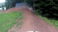
Little short trail coming off of Flume. Starts off with a wall ride into a tiny rock drop. Then there are a few mini jumps coming into the main feature. A gap jump to wall-ride. Then you go into a berm and there’s a wooden A-frame bridge that you can roll over or jump off the top.

Access Info

Bottom of Rooty Pebbles near the bottom of Flume (Access)

Bike Park

Traditionally Indigenous Territory

Recent Activity on Trail

Past Week
  • 13 rides
  • 30 miles average
6 Months
  • 55 rides
  • 24 miles avg distance
All
  • 923 rides
  • Last: Jun 20, 2026
c1c2c3c4
January
February
March
April
May
June
July
August
September
October
November
December
Status:
on May 28, 2026
Wet
Avg: 4.47 (13 votes)
Your vote: 0

view (18,465)
close
3D
Trail Conditions
  • Unknown
  • Snow Groomed
  • Snow Packed
  • Snow Covered
  • Snow Cover Partial
  • Freeze/thaw Cycle
  • Icy
  • Prevalent Mud
  • Wet
  • Variable
  • Ideal
  • Dry
  • Very Dry
Trail Flow (Ridden Direction)
Trailforks scans users ridelogs to determine the most popular direction each trail is ridden. A good flowing trail network will have most trails flowing in a single direction according to their intension.
The colour categories are based on what percentage of riders are riding a trail in its intended direction.
  • > 96%
  • > 90%
  • > 80%
  • > 70%
  • > 50%
  • < 50%
  • bi-directional trail
  • no data
Trail Last Ridden
Trailforks scans ridelogs to determine the last time a trail was ridden.
  • < 2 days
  • < 1 week
  • < 2 weeks
  • < 1 month
  • < 6 months
  • > 6 months
Trail Ridden Direction
The intended direction a trail should be ridden.
  • Downhill Only
  • Downhill Primary
  • Both Directions
  • Uphill Primary
  • Uphill Only
  • One Direction
Contribute Details
Colors indicate trail is missing specified detail.
  • Description
  • Photos
  • Description & Photos
  • Videos
Trail Popularity ?
Trailforks scans ridelogs to determine which trails are ridden the most in the last 9 months. Trails are compared with nearby trails in the same city region with a possible 25 colour shades. Think of this as a heatmap, more rides = more kinetic energy = warmer colors.
  • most popular
  • popular
  • less popular
  • not popular
ATV/ORV/OHV Filter
Max Vehicle Width
inches
US Cell Coverage
Legend
cell carrier legend

Radar Time
Activity Recordings
Trailforks uses anonymized public activity data. ?
Activity Recordings
Trailforks uses anonymized public activity data. ?
Personal Heatmap
Activity Types
all / none
Options
2
Date range month
Winter Trails
Warning A routing network for winter maps does not exist. Selecting trails using the winter trails layer has been disabled.
Missing Trails
Most Popular
Least Popular
Trails are colored based on popularity. The more popular a trail is, the more red. Less popular trails trend towards green.
Jump Magnitude Heatmap
Heatmap of where riders jump on trails. Zoom in to see individual jumps, click circles to view jump details.
BC Backroad Status

Service Road Atlas is a free to use, community-driven service for viewing and creating reports on the numerous back-country service roads around B.C. and Alberta.

map legend
Slope Aspect
Direction the slope faces
Flat N NE E SE S SW W NW
Trails Deemphasized
Trails are shown in grey.
disable
Only show trails with no bike usage.
Enable
Suggested Layers
Based on selected activity type

    Save the current map location and zoom level as your default home location whenever this page is loaded.

    Save
        Directions to raging-bull trailhead (38.414020, -79.986840)

        Photos

        28 more »
        61 |
        Nov 1, 2023 @ 7:11am
        Nov 1, 2023
        107 |
        Aug 27, 2020 @ 6:19pm
        Aug 27, 2020
        82 |
        Aug 27, 2020 @ 6:19pm
        Aug 27, 2020
        552 |
        Sep 17, 2016 @ 7:13pm
        Sep 17, 2016

        Videos

        11 more »
        The OG Trail - 4K POV #dhse  #mtb #downhillmtb...
        14:00 | 27 | Aug 14, 2025 , Snowshoe Village
        Snowshoe Mountain Bike Park raw full run down...
        8:57 | 82 | Sep 15, 2023 , Snowshoe Village
        Snowshoe WV Bike Park Tour | Mountain Biking
        18:25 | 157 | Jul 27, 2022 , Snowshoe Village
        Day 1 @ Snowshoe
        4:30 | 451 | Oct 17, 2014 , Snowshoe Village

        Routes with this trail

        23 miles 3,571 ft 16 Loop Race
        Stage 1- Access to next Stage- Ballhooter Lift, to top of M Stage 2- M & O Access to next Stage- Pedal to...

        Reviews / Comments

        No reviews yet, be the first to write a review or ask a question.
        Use trail reports to comment on trail conditions.


        We hope you've been enjoying Trailforks!

        Create a FREE account to view trail comments and much more.

        • By rsdobbins & contributors
        • #6009 - 3,100 views

        Frequently Asked Questions About Raging Bull

        Where is Raging Bull located?
        Raging Bull is located in Snowshoe Bike Park, Snowshoe Village, West Virginia, United States. It is part of the Snowshoe Bike Park trail network. The trailhead is located at coordinates 38.41402, -79.98684.
        How hard is Raging Bull?
        Raging Bull is rated as Blue difficulty. The physical rating is Moderate. The average grade is 12.5%.
        What is the elevation gain for Raging Bull?
        The trail has 111 ft of elevation descent. The elevation ranges from 4,075 ft to 4,186 ft.
        Is Raging Bull a point to point trail?
        Yes, Raging Bull is a point to point trail. The direction is Downhill Only. The trail type is doubletrack.

        Hit the Trail

        Open in App

        Get this trail on your phone instantly.
        open trail in app

        Download Trail

        Save to wishlist, Garmin & download.
        save the trail

        Find Related Routes

        Find routes and users activities that include this trail.
        find routes for this trail

        You must enter a description before submitting.