more stats
21.7 miles
Distance
1,792 ft
Climb
-1,446 ft
Descent
03:37:17
Avg time
348 ft
Altitude change
7,491 ft
Altitude min
7,945 ft
Altitude max
7,596 ft
Altitude start
7,946 ft
Altitude end
0.3%
Grade
-34.3%
Grade max
26.6%
Grade min
11 miles
Distance climb
9 miles
Distance down
2 miles
Distance flat
03:37:17
Avg time

Rainbow Rim Details

  • Activities
    • Mountain Bike
    • Hike
    • Trail Running
  • Riding Area
    Kaibab Plateau
    Jacob Lake, Arizona
  • Difficulty Rating
  • Local Popularity
    95 in Mountain Biking [+]
    • 5 in Trail Running
    • 5 in Hiking
  • Global Ranking
    #46546 in Mountain Biking [+]
    • #105474 in Trail Running
    • #102250 in Hiking
  • Hiking SAC Scale
    T1 Hiking
  • Trail Type
    Singletrack
  • Bike Type
    XC
  • Direction
    Both Directions
    Popular Direction Shown
  • Climb Difficulty
    Blue
  • Physical Rating
    Moderate
  • Trail Visibility
    Always easy to follow
  • Season
    spring, summer, autumn
  • Dogs Allowed
    Yes
  • Land Owner
    USFS

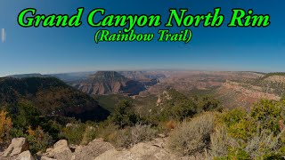
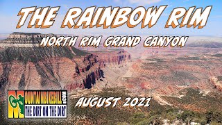
Singletrack along the north rim of the Grand Canyon. Trail contours a series of drainages through the forest poking out to a few canyon overlooks along the way. Recently the south end has been extended approximately four miles with the ultimate goal of adding more trail in the future to hopefully make the trail a loop.The new section is more twisty than the original alignment with no major climbs.

Trail Supporters

  • USFS
    Land Manager
Local Trail Association
Traditionally Indigenous Territory

Recent Activity on Trail

Past Week
  • 0 rides
  •  
6 Months
  • 0 rides
  •  
All
  • 16 rides
  • Last: Jun 4, 2026
c1c2c3c4
January
February
March
April
May
June
July
August
September
October
November
December
update trails status or condition

Rainbow Rim Trail Reports

statusdatedescription
May 30, 2026 @ 7:06am (America/Phoenix)
May 30, 2026
Major erosion (major ruts or slumping, large boulders and roots exposed due to erosion)o gfthe river t
Sep 1, 2025 @ 11:21am
Sep 1, 2025
Trail is CLOSED south of Timp Pt. All areas south of FS271 are closed due to the Dragon Bravo...
Jun 11, 2024 @ 10:22am
Jun 11, 2024
Rode it 6/7-8/24. Great shape, all clear and dry. Total of 2 deadfall between Timp and Parissawampitts Points.
May 13, 2024 @ 3:30am
May 13, 2024
Trail became impassable. Downfall, some snow patches, and 1 million pinecones to get stuck between tire and frame.
Sep 17, 2023 @ 6:36pm
Sep 17, 2023
Blue/intermediate level biking because of the elevation, some limited steep sections and the rock bed on the trails. Get good maps to get in to...
more »
Status:
on May 30, 2026
Avg: 4.21 (8 votes)
Your vote: 0

view (101)
close
3D
Trail Conditions
  • Unknown
  • Snow Groomed
  • Snow Packed
  • Snow Covered
  • Snow Cover Partial
  • Freeze/thaw Cycle
  • Icy
  • Prevalent Mud
  • Wet
  • Variable
  • Ideal
  • Dry
  • Very Dry
Trail Flow (Ridden Direction)
Trailforks scans users ridelogs to determine the most popular direction each trail is ridden. A good flowing trail network will have most trails flowing in a single direction according to their intension.
The colour categories are based on what percentage of riders are riding a trail in its intended direction.
  • > 96%
  • > 90%
  • > 80%
  • > 70%
  • > 50%
  • < 50%
  • bi-directional trail
  • no data
Trail Last Ridden
Trailforks scans ridelogs to determine the last time a trail was ridden.
  • < 2 days
  • < 1 week
  • < 2 weeks
  • < 1 month
  • < 6 months
  • > 6 months
Trail Ridden Direction
The intended direction a trail should be ridden.
  • Downhill Only
  • Downhill Primary
  • Both Directions
  • Uphill Primary
  • Uphill Only
  • One Direction
Contribute Details
Colors indicate trail is missing specified detail.
  • Description
  • Photos
  • Description & Photos
  • Videos
Trail Popularity ?
Trailforks scans ridelogs to determine which trails are ridden the most in the last 9 months. Trails are compared with nearby trails in the same city region with a possible 25 colour shades. Think of this as a heatmap, more rides = more kinetic energy = warmer colors.
  • most popular
  • popular
  • less popular
  • not popular
ATV/ORV/OHV Filter
Max Vehicle Width
inches
US Cell Coverage
Legend
cell carrier legend

Radar Time
Activity Recordings
Trailforks uses anonymized public activity data. ?
Activity Recordings
Trailforks uses anonymized public activity data. ?
Personal Heatmap
Activity Types
all / none
Options
2
Date range month
Winter Trails
Warning A routing network for winter maps does not exist. Selecting trails using the winter trails layer has been disabled.
Missing Trails
Most Popular
Least Popular
Trails are colored based on popularity. The more popular a trail is, the more red. Less popular trails trend towards green.
Jump Magnitude Heatmap
Heatmap of where riders jump on trails. Zoom in to see individual jumps, click circles to view jump details.
BC Backroad Status

Service Road Atlas is a free to use, community-driven service for viewing and creating reports on the numerous back-country service roads around B.C. and Alberta.

map legend
Slope Aspect
Direction the slope faces
Flat N NE E SE S SW W NW
Trails Deemphasized
Trails are shown in grey.
disable
Only show trails with no bike usage.
Enable
Suggested Layers
Based on selected activity type

    Save the current map location and zoom level as your default home location whenever this page is loaded.

    Save
        Directions to rainbow-rim trailhead (36.418730, -112.367020)

        Photos

        78 more »
        762 |
        Oct 23, 2014 @ 11:56am
        Oct 23, 2014
        732 |
        Aug 29, 2010 @ 9:12am
        Aug 29, 2010
        265 |
        Jun 1, 2022 @ 8:50am
        Jun 1, 2022
        348 |
        Oct 12, 2021 @ 10:13pm
        Oct 12, 2021

        Videos

        3 more »
        youtuber Mountain Biking the Grand Canyon on...
        10:06 | 927 | Aug 24, 2020 , Jacob Lake
        youtuber Grand Canyon MTB at North Rim - Rainbow Rim Trail
        16:37 | 328 | Feb 26, 2024 , Jacob Lake
        The Rainbow Rim Trail - North Rim of the Grand...
        9:13 | 716 | Nov 13, 2021 , Jacob Lake

        Routes with this trail

        5.0 160 miles 14,913 ft 3 Loop
        Best done as a CCW loop from Jacob Lake over 3 days. The first half of the ride is mostly forest roads,...
        21 miles 1,199 ft 1 Point to Point
        Can also be completed as an out-and-back.
        144 miles 12,275 ft 8 Loop
        The main loop starts at and follows mostly dirt roads to the north rim of the Grand Canyon. From there the...

        18 Reviews & Comments


        We hope you've been enjoying Trailforks!

        Create a FREE account to view trail comments and much more.

        • By schillingsworthTF Pro TRAILFORKS HTA & contributors
        • #16126 - 15,691 views

        Frequently Asked Questions About Rainbow Rim

        Where is Rainbow Rim located?
        Rainbow Rim is located in Kaibab Plateau, Jacob Lake, Arizona, United States. It is part of the Kaibab Plateau trail network. The trailhead is located at coordinates 36.41873, -112.36702.
        How hard is Rainbow Rim?
        Rainbow Rim is rated as Blue difficulty. The physical rating is Moderate. The average grade is 0.3%. The climb difficulty is rated Blue.
        What is the elevation gain for Rainbow Rim?
        Rainbow Rim has 1,792 ft of elevation gain. The trail has 1,446 ft of elevation descent. The elevation ranges from 7,491 ft to 7,945 ft.
        Is Rainbow Rim a point to point trail?
        Rainbow Rim is not a point to point trail. The direction is Both Directions. The trail type is singletrack.

        Hit the Trail

        Open in App

        Get this trail on your phone instantly.
        open trail in app

        Download Trail

        Save to wishlist, Garmin & download.
        save the trail

        Find Related Routes

        Find routes and users activities that include this trail.
        find routes for this trail

        You must enter a description before submitting.