more stats
8.6 miles
Distance
753 ft
Climb
-2,090 ft
Descent
01:37:01
Avg time
-1,337 ft
Altitude change
2,688 ft
Altitude min
4,059 ft
Altitude max
4,059 ft
Altitude start
2,723 ft
Altitude end
-2.9%
Grade
-44.4%
Grade max
26.7%
Grade min
3 miles
Distance climb
5 miles
Distance down
3,691 ft
Distance flat
01:37:01
Avg time

Razorback Details

  • Activities
    • Mountain Bike
    • Hike
    • Trail Running
  • Riding Area
    Boer Mountain and Kager Lake
    Burns Lake, British Columbia
  • Difficulty Rating
  • Voted Difficulty
    Blue (1 vote)
  • Local Popularity
    35 in Mountain Biking [+]
    • 85 in Trail Running
    • 5 in Hiking
  • Global Ranking
    #103264 in Mountain Biking [+]
    • #20746 in Trail Running
    • #122265 in Hiking
  • Trail Type
    Singletrack
  • Bike Type
    XC
  • Direction
    Both Directions
  • Climb Difficulty
    Black Diamond
  • Physical Rating
    Hard
  • Dogs Allowed
    Yes

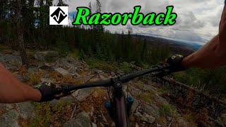
A wicked trail that can be ridden both ways. Ride up the road to the top of the mountain to ride down the trail or make your way along the lake on an old school trail to the bottom. Lots of variety on this trail: rocky sections, flowy switchbacks, little jumps, and great berms. This trail provides climbing in both directions but is easier if started from the top of the mountain.

Local Trail Association
Traditionally Indigenous Territory

Recent Activity on Trail

Past Week
  • 1 rides
  • 16 miles average
6 Months
  • 1 rides
  • 16 miles avg distance
All
  • 23 rides
  • Last: Jun 10, 2026
c1c2c3c4
January
February
March
April
May
June
July
August
September
October
November
December
Status:
on May 13, 2026
Ideal
Avg: 4.33 (13 votes)
Your vote: 0

view (189)
close
3D
Trail Conditions
  • Unknown
  • Snow Groomed
  • Snow Packed
  • Snow Covered
  • Snow Cover Partial
  • Freeze/thaw Cycle
  • Icy
  • Prevalent Mud
  • Wet
  • Variable
  • Ideal
  • Dry
  • Very Dry
Trail Flow (Ridden Direction)
Trailforks scans users ridelogs to determine the most popular direction each trail is ridden. A good flowing trail network will have most trails flowing in a single direction according to their intension.
The colour categories are based on what percentage of riders are riding a trail in its intended direction.
  • > 96%
  • > 90%
  • > 80%
  • > 70%
  • > 50%
  • < 50%
  • bi-directional trail
  • no data
Trail Last Ridden
Trailforks scans ridelogs to determine the last time a trail was ridden.
  • < 2 days
  • < 1 week
  • < 2 weeks
  • < 1 month
  • < 6 months
  • > 6 months
Trail Ridden Direction
The intended direction a trail should be ridden.
  • Downhill Only
  • Downhill Primary
  • Both Directions
  • Uphill Primary
  • Uphill Only
  • One Direction
Contribute Details
Colors indicate trail is missing specified detail.
  • Description
  • Photos
  • Description & Photos
  • Videos
Trail Popularity ?
Trailforks scans ridelogs to determine which trails are ridden the most in the last 9 months. Trails are compared with nearby trails in the same city region with a possible 25 colour shades. Think of this as a heatmap, more rides = more kinetic energy = warmer colors.
  • most popular
  • popular
  • less popular
  • not popular
ATV/ORV/OHV Filter
Max Vehicle Width
inches
US Cell Coverage
Legend
cell carrier legend

Radar Time
Activity Recordings
Trailforks uses anonymized public activity data. ?
Activity Recordings
Trailforks uses anonymized public activity data. ?
Personal Heatmap
Activity Types
all / none
Options
2
Date range month
Winter Trails
Warning A routing network for winter maps does not exist. Selecting trails using the winter trails layer has been disabled.
Missing Trails
Most Popular
Least Popular
Trails are colored based on popularity. The more popular a trail is, the more red. Less popular trails trend towards green.
Jump Magnitude Heatmap
Heatmap of where riders jump on trails. Zoom in to see individual jumps, click circles to view jump details.
BC Backroad Status

Service Road Atlas is a free to use, community-driven service for viewing and creating reports on the numerous back-country service roads around B.C. and Alberta.

map legend
Slope Aspect
Direction the slope faces
Flat N NE E SE S SW W NW
Trails Deemphasized
Trails are shown in grey.
disable
Only show trails with no bike usage.
Enable
Suggested Layers
Based on selected activity type

    Save the current map location and zoom level as your default home location whenever this page is loaded.

    Save
        Directions to razorback trailhead (54.256600, -125.677750)

        Photos

        24 more »
        136 |
        Aug 13, 2021 @ 12:26pm
        Aug 13, 2021
        343 |
        Feb 3, 2021 @ 10:33pm
        Feb 3, 2021
        151 |
        Jul 23, 2020 @ 12:39pm
        Jul 23, 2020
        125 |
        Jul 23, 2020 @ 12:27pm
        Jul 23, 2020

        Videos

        2 more »
        youtuber Best mountain biking in Burns Lake, BC - Razorback
        21:11 | 252 | Mar 25, 2025 , Burns Lake
        youtuber Burns Lake | Northern BC MTB
        10:17 | 885 | Apr 7, 2020 , Burns Lake

        Routes with this trail

        3.0 5 miles 179 ft 7 Shuttled
        One heck of a great all mountain ride. Upper has incredible viewpoints, technical rock sections, some fast...
        3.0 10 miles 1,601 ft 13 Loop
        20km climbing ride up to for those that don't want to climb the entire mountain.
        9 miles 752 ft 7 Shuttled
        When you only have 1 shuttle, and you want to make the most of it, take The Long Way Down. Mostly...

        7 Reviews & Comments


        We hope you've been enjoying Trailforks!

        Create a FREE account to view trail comments and much more.

        Frequently Asked Questions About Razorback

        Where is Razorback located?
        Razorback is located in Boer Mountain and Kager Lake, Burns Lake, British Columbia, Canada. It is part of the Boer Mountain and Kager Lake trail network. The trailhead is located at coordinates 54.2566, -125.67775.
        How hard is Razorback?
        Razorback is rated as Black Diamond difficulty. The physical rating is Hard. The average grade is 2.9%. The climb difficulty is rated Black Diamond.
        What is the elevation gain for Razorback?
        Razorback has 230 m of elevation gain. The trail has 637 m of elevation descent. The elevation ranges from 819 m to 1,237 m.
        Is Razorback a point to point trail?
        Razorback is not a point to point trail. The direction is Both Directions. The trail type is singletrack.

        Hit the Trail

        Open in App

        Get this trail on your phone instantly.
        open trail in app

        Download Trail

        Save to wishlist, Garmin & download.
        save the trail

        Find Related Routes

        Find routes and users activities that include this trail.
        find routes for this trail

        You must enter a description before submitting.